What to see on the island of Saaremaa. Saaremaa island, Estonia Saaremaa island, Estonia
I will not delve into the history of the island in detail. Let me just say that in the summer of 1941, Soviet air raids on Berlin were carried out from here, and after the war and before the collapse of the Union, the territory was a border zone. Getting to the island was difficult. There are now ferries to Saaremaa from mainland Estonia and from the neighboring island of Hiiumaa. I already wrote about the ferry and about the island in the winter, after my last visit here.
1. The capital of the island is the city of Kuressaare (in Soviet times, Kingisepp). Quiet town, in the center of an interesting.
and more about him
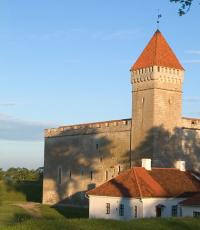
2. Bishop's castle in Kuressaare. In previous posts about the city, I talked about it
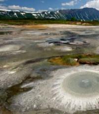
3. It turns out that Estonia is a country of meteorite craters. There are more of them here than anywhere else in the world. The most famous crater - Kaali - reaches 110 meters in width. 3000 years ago, a fragment of a meteorite the size of a 20-story building fell here. Whatever they thought about this crater before. It was considered both an entrance to hell, and the grave of the son of Apollo, and an anomalous zone.
By the way, by the standards of craters, Kaali has a child's age: he is the youngest in Europe
4. It's not a crater, but you don't want to leave the forests of Saaremaa
6. Ancient churches are one of the hallmarks of Saaremaa. Lutheran Church of Saint Martin
7. Built in the 13th-14th centuries. One of the oldest in the country!
8. Church of St. Catherine in Kärla, about the same age
9. About the local churches that I liked the most, I will write separately
12. The owner of the island met in one of the churchyards)
13. There are also Orthodox churches. Approximately all of the same age - the middle and the end of the 19th century
14. Handle on the door of one of the Orthodox churches
15. And this is how they live in Saaremaa. No fences, lawn, Swedish Faloon color house
16. On the way we notice an abandoned
17. But it turned out that this is the territory of an Orthodox monastery
18. As soon as we entered the territory, a nun came out to us. She greeted me very politely, gave me a tour of the monastery and treated me to plum juice and cookies. Of course, she didn't ask for money.
Then we talked a little. The nun asked about Russia and was very surprised to learn that in our monasteries, especially in women's, there was nothing to count on such a reception. Unfortunately.
Having bought monastery jam from local flattering berries, herbal tea and donating for hospitality, we go further
23. There are hillforts in Saaremaa. It is located in the town of Kaarma. It is interesting to archaeologists as a place of ancient finds (somehow they found decorations of the 12th-13th centuries and charred logs of fortifications), to local residents - as a place for sledding in winter
24. In summer they ride on an interesting swing that I have already come across in Setomaa
25. From more serious military fortifications, you can see the ruins of the order castle Maasi (Zoneburg). The castle stood at the crossroads of important routes, controlled the strait between the islands of Saaremaa and Muhu. Built by the master of the Livonian Order in the 14th century and named Soneburg (Soneburg), which means "castle in retribution" in German.
Later it was rebuilt and expanded, participated in wars, was captured by the Swedes. In 1576, the Danes, on the orders of the king, blew up the castle, after which it ceased to exist forever as a military facility.
Now partially restored and turned into a recreation area
27. The coast near the castle is decorated with just such a boat. I just don’t know if they brought her on purpose, or if she lives out her life here from the very beginning. For greater aesthetics, there is not enough tree sprouted through the bottom
28. One of the manors (manors) of the island
29. Shop in an old building
30. On the northern coast of Saaremaa there is the Panga cliff, which rises to 21 meters
31. Saaremaa - island of windmills. The most famous are in the town of Angla. At first I thought it was some kind of village where many mills were preserved, but Angla turned out to be a museum
32. Moreover, the museum is small and uninteresting, unless of course you are an expert in windmills. The territory is fenced, but the whole area is perfectly visible due to the small area.
34. And another mill, literally a kilometer from the museum
35. Some windmills are converted into such characters) Ninaze town in the north of the island
36. Be sure to visit Saaremaa!
You can stay in hotels and hostels in Kuressaare and in guest houses throughout the island;
- it is better to come by car, since the island is large (about 88 by 90 km), interesting places are scattered throughout the territory;
- public transport: buses run from major Estonian cities to Kuressaare. Some of them enter settlements with sights, but mostly they go along the route from the ferry to Kuressaare, along which there is almost nothing interesting;
- there are also lighthouses (we didn’t get to the most interesting, and after Hiiumaa we already wanted to see something else), natural monuments, a farm museum. In 2008, in the town of Salme, 200 meters from the sea, a Viking ship was discovered, which contained 7 skeletons. The analysis showed that the ship was built between 650-700 years. Two years later, another ship was discovered, in which 33 skeletons were neatly stacked. According to historians, this may be the burial place of the Swedish king Ingvar the High who attacked these lands;
- for a not very detailed inspection of the entire island, you need at least 3 days.
Including the fact that one should not overestimate the unpronounceability of its name - Estonian Russians simply say "Sarema", and by trying to pronounce 4 "a" they instantly figure out a tourist. Or that the former Ezel among all the islands in the countries of the former USSR is the second largest in terms of population (35 thousand inhabitants) after Sakhalin and, along with Bolshoi Solovetsky, is a clear leader in historical heritage.
The island, like the city, is a closed system, and therefore I will talk about it in three parts, where the different ends of the island are mixed up, and the general ones are themes and aspects. In the first part, more about the nature of the interior of the island (and there is even a real meteorite crater here!) And pre-revolutionary antiquity like churches, manors or mills; in the second - about the most interesting sights of Saaremaa, gigantic medieval fortified churches; in the third - again about nature, first of all, the harsh shores of Syrve and Harilaid, and the heritage of the twentieth century, be it lighthouses or Soviet military bases. In addition, there was also a "zero" part about a dam fused with Saaremaa.
The former Ezel is a really BIG island: a hundred kilometers from west to east, fifty from north to south, not counting the long offshoot of the Syrve peninsula. This, it should be noted, makes it extremely difficult to inspect its antiquities without a car: “everything is nearby” on one’s own wheels, but it’s far away on foot, there are few buses, I didn’t check the hitchhiking, but the roads here are very deserted. And unlike Muhu or, where you can’t forget for a minute that you are on an island in the middle of the sea, Saaremaa in places is not very different from the mainland: the same forests and fields. But in the fields, as in the title frame, blooming poppies are not uncommon, and in the forest it happens like this:
The proximity of the sea usually gives out a "drunken forest", quite worthy of the Dancing Forest on:
And the Ezel shores, firstly, are extremely cunningly indented, and secondly, they are very diverse. Somewhere - meadows and swamps, more often I came across these closer to the mainland and the island of Muhu, which is here in the background:
Somewhere - windy rocky wastelands (in Estonia they are called alvars), I remember this way the western coast facing the open Baltic, especially the Harilaid peninsula:
And somewhere - classic cliffs (or, as they are called in Estonia, "punks"), reaching an impressive height - for example:
This is the Great Ledge, or the Baltic-Ladoga Glint, which we have already met in Estonia (although I showed it like 4 months ago) - for example, in the industrial Ida-Virumaa, in the port or even in Tallinn, built on top of a rocky remnant. Glint begins under the water of the Baltic near the Swedish island of Eland and stretches for more than a thousand kilometers, beyond Narovaya they go far from the sea, to the southern shore of Lake Ladoga, strung together with Estonian castles (,) and Ingrian fortresses (,), and it is not quite obvious that Saaremaa and Hiiumaa lie on opposite sides of it. But there is still no consensus on the origin of the clint - either the ancient coast (of a river or sea), or the bed of a glacier, as if pressed into the earth's thickness by it ... The highest cliffs are in Ida-Virumaa (up to 56 meters ), but the Panga cliff on Saaremaa, which is only 22 meters, feels even higher:
Here the coast is turned to the northeast, to the open Baltic. In the background, the Ninase peninsula with the remnants of Soviet batteries and its own cliffs, barely visible from here, and behind it Tagalakht Bay, where German troops landed in 1917.
But the shores, although the most photogenic place in Saaremaa, make up only a small part of it - nevertheless, basically here, as already mentioned, the landscape is not very different from the mainland, except that the air is cleaner, the grass is greener, life is more measured and the villages are extraordinary an abundance of mossy stone fences, which have become one of the symbols of the island:
The most famous natural landmark is also located in the center of the island, in the village Kaali 20 kilometers from Kuressaare, and the pepelats standing in the middle of the forests, as it were, hints that there will be something cosmic ahead:
Although the first thing you meet is a hotel with a restaurant, souvenir shops and several buses with pensioners in the parking lot:
About 4 thousand years ago, that is, already in the memory of people, including those who lived directly on Saaremaa, a meteorite weighing several hundred tons fell here - and not icy, like a couple of years ago in Chelyabinsk, but quite metal, that is, flying to the ground and punched in it a full-fledged crater. And since 4000 years is "almost just" by geological standards, the crater is well preserved and, of course, has become one of the main sights of the island. Souvenirs nearby, however, not of a space theme, but folk art common to Saaremaa - there are a lot of private workshops on local farms:
Here is the crater itself, surrounded by a noticeable "shaft" - its depth is 16 meters, its diameter is 110 meters, and at the bottom is Kaaliyarv Lake. The fall of the fiery star is reflected in Scandinavian legends and songs, while the ancestors of the Estonians came here later and their legend is not so global - supposedly, at this place the church, in which the brother and sister got married, fell through the ground. It is also amazingly similar to - only there at the bottom there is not a lake, but a swamp, and the origin has not been clarified.
Blocks of stone, scattered from the impact and cleared in our time from the stratified earth. The meteorite flew at a speed of several tens of kilometers per second, and the explosion burned out the forest for 6 kilometers around, and the content of nickel, one of the most characteristic "meteorite" metals, was increased in the ground and the remains of burnt trees.
But in general, especially in combination with crowds of tourists, in practice all this is not as impressive as in theory:
Kaali, like any "package" attraction, has a "second bottom" - after all, the meteorite broke into pieces while still in the air, and the Main Crater was knocked out by the largest fragment weighing up to 80 tons. Small fragments burned up in the atmosphere, according to the laws of physics at such a speed, they were erased into ashes on the air, but nevertheless, 9 fragments, including the main one, flew to the ground, leaving 9 craters, respectively, within a radius of a couple of kilometers from the extreme to the extreme. We did not look for all of them, limiting ourselves to those closest to the road. The main crater is unnumbered, but the barely visible crater No. 6 at the curb:
Behind the trees near the road in the field, a round grove is visible, hiding the second largest crater No. 1:
Everything is carefully provided with diagrams and information stands, and this crater, although smaller and without a lake, still impresses almost more than the main one in the absence of tourists:
In total, five meteorite craters (or rather, similar placers) are known in Estonia, of which only two are on the mainland (Ilumetsa and Tsyyrikmäe, and also "young"). There is a Kärdla crater on Hiiumaa, huge (4 kilometers wide) and very old (400 million years ago), and therefore almost invisible to the layman, and the Naugrund crater is completely 25 meters under water near the island of Osmussaar (Odensholm) in the northwestern corner of Estonia. To be honest, I don’t understand very well that meteorites are so attracted to Estonia (of course, much more of them fell to Siberia, but the sizes are not comparable!), but the concentration of their craters here is really unique.
As already mentioned, people caught the fall of the Kaali meteorite. Who they were then is not exactly clear, but the name Ezel itself goes back to the Varangian Eysula, and in 2008, near the village of Salme, two decayed boats of the 7th century were found with the skeletons of several dozen Vikings, most likely who died on a campaign against the Estonian natives. The local proto-Estonians, who are called Osilians in some places, were themselves, of course, not Vikings, but pirates who kept the entire Baltic in fear and ruined Danish possessions in present-day Sweden - as follows from the chronicles, they had a full-fledged fleet of 16 ships and about half a thousand warriors . The Danish king Woldmar II, who later conquered Estonia, was unable to capture Ezel in 1206, but in 1227 the Crusaders did it. The Osilians kept themselves apart, they did not particularly help their mainland brethren in battles with the Germans, and given this, as well as their warlike disposition, the Germans left some semblance of autonomy to the Esel natives, which lasted until the 14th century, when castles and churches were already built here. In 1322, the Bishop of Ezel-Vik moved to the island, and I suspect that it was then that the screws were tightened on the islanders, which turned into the last and bloodiest round of the St. after him, Ezel was completely subordinated to Livonia. However, many Ossilian settlements are scattered around the island, such as this one in Kaarma, from a distance similar to another meteorite crater:
Now, in the ancient fortress, the descendants of the Osilians sing and celebrate. In the middle stands a monument, apparently to the victims of the St. George's Night uprising. In the background is the spire of the medieval church of Kaarma (Carmel) - I will talk about it in more detail in the next part:
The Germans divided Ezel between the Order and the Ezel-Vik Bishopric, with the former getting the east (including neighboring Moon/Muhu) and the northwest. Bishop Arensburg is not the only castle in Saaremaa, there are still the ruins of the order Zoneburg on the east coast, almost opposite the museum village of Koguva on Muhu. But still, the main monument of the Livonian Middle Ages here are not castles, but churches - unusually huge (on the scale of Tallinn and Riga), utterly medieval in spirit and clearly designed for defense. The easternmost one is the church of St. Catherine on the island of Muhu, I have already shown in the corresponding post, and now let's go to the village Kihelkonna(literally - "Parish"), the former center of the western Ezel possessions of the Order, where the Church of Michael the Archangel is located - the westernmost and at the same time the most "continental" in its appearance:
In principle, I have already shown similar churches - be it Harju-Risti and Harju-Madis in a, or even Jõhvi in the same post where the Vallaste waterfall was - but only Kihelkonna is larger than any rural church on the mainland. It began to be built in the 1250s, and its altar part is almost the oldest building in Estonia, while the current tower was built only in 1899:
At the gate we were met by a bent old woman with a wand and a sad look, more familiar in the Central Russian outback. The parish (kihelkond) of Kihelkonna is not crowded, is not spoiled by the attention of tourists, and therefore is very poor. The church is damp, uncomfortable, smells of mold, the ceiling is reinforced with wooden rafters - all this looks a bit hopeless:
The decoration here is not as fantastic as in the churches that I will show in the next part - but there is something to see here. What is worth one chandelier, and behind the back is the oldest organ in Saaremaa (1805):
Under the lancet vaults - the pulpit and the altar (1591) with the "Last Supper":
You can climb the tower by dark stairs, from which you can see the courtyards of farms at the foot, forest-meadows and the distant sea with indented shores. In good weather, you can see the 37-meter lighthouse (1809) on the island of Vilsandi (Felsland), most of which is occupied by an ornithological reserve founded by one of the lighthouse keepers, but no matter how I rummaged around with an ultrasonic, I couldn’t see anything in the gray haze. The children of the late ESSR are more familiar with "One-eyed Silver, a terrible robber from the island of Felsland", who in fact was, in fact, a downshifter who moved from the city to a remote island and became the hero of the book ... This is the western edge of Saaremaa, further the cold sea all the way to Gotland :
Having descended, we heard the bell and went to the belfry - it is medieval here, and does not look like a slender bell tower, but a rough, purely functional, U-shaped arch. And in the general picture of the harsh stone buildings, the leaden sky and the cold wind from the gray sea, the damp hall with the smell of mold, the sad caretaker with doom in her eyes, the rare strikes of the bell sounded somehow especially gloomy: "for whom does it ring?".
Imagine our surprise when the belfry was empty! No, in fact, of course, the bell is simply automatic (which somehow does not fit, by the way, with the general poverty of the parish - maybe someone gave it as a gift?), but in combination with the general atmosphere of the place it seemed to me that it was 1710 year, and in the land devastated by the plague, either the wind beats the bell, or the ghost of the deceased pastor ...
There were once three similar belfries on Saarem, but the other two were demolished in the late USSR, and not even under Khrushchev, but in the late 1970s, and it’s not even clear why they closed the plan to combat religion (churches then they just didn’t break it very much!), or some party bump urgently needed a stone for a summer residence. Let's say the belfry in Kärla, demolished in 1980:
But basically Churches on Saaremaa times not so distant, the same Kihelkonna is separated from them by the collapse of Livonia, Danish (1559-1645) and Swedish (until 1710) domination and the Ezelsky district of the Livonian province. Let's say that same Kyarla - the church of Mary Magdalene (1847), which got into the frame along the way. From the stones of its medieval predecessor, dismantled for dilapidation, the Mihkli farm was built - I showed one of the stones of the vault in its summer kitchen:
Or the Jaanovskaya Church (1703) near Orisaare and the same Zoneburg Castle - in general, they are simple and unprepossessing here:
But almost more often, churches on Saaremaa come across Orthodox churches, mostly typical and very characteristic architecture. About the mass transition of Estonians to Orthodoxy in the hope of getting rid of the baronial oppression and the provision of Russian lands (they were presented - but far from Estonia) and the equally massive exodus back to Lutheranism after 1905 (when it was allowed to rebaptize Orthodox in other religions, and resentment the Estonians got a lot of money for the royal power that supported the barons) I wrote more than once, and it seems that it was especially widespread on the islands - here, in the most mono-ethnic part of Estonia, Orthodox churches come across almost more often than on the mainland. On the same Muhu, at one time, 70% of the population walked under the eight-pointed cross. The characteristic appearance of the churches of the Ezelsky district with a large dome and cupolas on the towers "adhered" to it goes back to the temples, either, or, and this is a typical project - I can’t even identify which church out of several is depicted in the following frame:
Slightly different version. They were all built almost simultaneously, consecrated in 1873 - even the Lithuanian "ants" would envy such consistency and seriality, despite the fact that the Ezel churches have much more interesting and original architecture - not a dull pseudo-Russian style, but an attempt to create something local , Orthodox "in the Ostsee way". However, we never got to the most interesting samples - the "first among equals" (in my opinion) of the Church of the Intercession in Tornimäe and the skete of John the Baptist in Ryaomäe (the only monastery of the Patriarchate of Constantinople in Estonia), but in the aggregate Temples-1873 are a unique part of the Ezel landscape.
The slightly older (1867) Church of the Transfiguration in Lumanda looks more like a church. By the way, I don’t think it’s worth explaining that today most of these churches are part of the Patriarchate of Constantinople, which ministers (through the Estonian Apostolic Church) to Orthodox Estonians.
But the wooden Church of the Epiphany in Metskylä (1915) could well have been built for the Russian garrison who arrived on the Moonsunds from the First World War, or even brought from the mainland:
But in the forest at the crossroads there is a wooden Baptist prayer house - their time here came in the 1930s, and in general in the coastal wilderness, including in neighboring Courland, they preached a lot - in the museum of wooden architecture there is almost the same, there is a church inside hall and living room of the pastor.
As for we Z, then there are a good one and a half hundred of them on Saaremaa and Muhu - again, perhaps the highest density in the country, not counting maybe the environs of Tallinn. Only basically they are small and nondescript, but of course there will be some interesting ones: for example, Pilgus (Hohenechen) and Lahetagus (Lakhetagge) are the birthplace of Thaddeus Bellingshausen, the first (together with Lazarev and of course the team) man who saw Antarctica. Oti Manor (Puydehof) is considered the most beautiful, but who was with us on the first day
The Estonian island of Saaremaa is rich in sights. Many of them are connected with the sea, but there are also those whose origin puzzles even scientists, not to mention ordinary tourists. Going on a tour of Saaremaa, in just a few hours you can travel through time and space: from a fishing village to be transported to the distant XIV century, and then suddenly find yourself in a much later Middle Ages.
Windmill Museum.
There are several museums on Saaremaa, but if you choose to visit one, it is certainly the windmill museum. Firstly, the only one of its kind in the entire territory of Estonia. Secondly, here you can get an idea about the life of the islanders and along the way learn interesting facts from history.
The exposition is located in the open air, on the Angla Hill blown by all the winds. This place looks exactly like it did many years ago - when the mill was the source of life for the whole village, and sometimes for several surrounding settlements. Today, museum visitors can see five exhibits - four one-legged windmills typical of Saaremaa, and one Dutch one, the largest and having several floors. All of them were built at the beginning of the 20th century and remain in working condition to this day. This can be seen by looking inside. Paid entrance. The price is only 3.5 euros per adult and 1.5 per child.
In addition to the mills, the museum has a tavern where you can taste local cuisine (not Estonian, but local!) And a very unusual souvenir shop. In addition to the usual magnets and knick-knacks, they sell freshly baked bread and unfiltered homemade beer with juniper. The Windmill Museum does not have an address - but just tell any taxi driver about Angla Hill and you will be taken exactly where you need to be.
Bishop's Castle.

The Bishop's Castle is a symbol and visiting card of Saaremaa, and it is impossible to bypass it when you arrive on the island. After all, this is not just a fortress, but a “living” witness of successive eras. In addition, in the Baltics, this is the only medieval building that has been preserved in its original form.
It is not known when the construction of the citadel began. The first official mention of it dates back to 1381, but historians agree that the castle was founded much earlier, in the 13th century. Initially, it was planned as an administrative center, where, if necessary, local residents could hide and withstand the attack of enemies. In peacetime, general meetings were held on the central square.
In addition, until the beginning of the Livonian War, the castle was the residence of the Ezel-Vik bishops, hence the current name. In 1559, the fortress was sold to the Danes, who modernized the system of fortifications and “reinforced” it with an impressive moat 30 meters wide. In 1710, the citadel became the property of the Russian Empire and forever lost its defensive significance.
Today, the Bishop's Castle houses a museum where you can get acquainted with the history, traditions and culture of Saaremaa. It is located in the city of Kuressaare, at Lossihoov tn 1.
Castle-Church of Pöyde.

The uniqueness of Pöide Castle is primarily that the complex was originally built as a fortified church - until now, in some guidebooks it is designated as the Temple of St. Maarja. Unfortunately, little has survived from the original building to this day - built in 1343, it has been repeatedly changed and reconstructed. So, for example, the tower that made it recognizable appeared only in the 15th century. In the future, the church survived many fires.
Today, tourists can admire both the external and internal decoration of the complex - it is being actively restored and every year there are more and more interesting services in the temple, although it is adapted for this, they have not been held since Soviet times. Pöide castle-church is located at the address: Pöide küla, Pöide vald, Saare maakond.
Kaali meteorite crater.

The field of meteorite craters, the largest of which is Kaali, is one of the most mysterious sights not only on the island of Saaremaa, but throughout Estonia. For a long time it was believed that landscape formations are of volcanic origin, but in 1937 geologists found irrefutable evidence of another version - the craters were formed as a result of a meteorite fall.
When this happened, it is not known exactly: some scientists claim that eight thousand years ago, others - four thousand. They agree on only one thing - the destruction caused by a celestial body was comparable to the effect of an atomic bomb explosion. And this despite the fact that at an altitude of 5-10 kilometers from the ground, the meteorite exploded, and only fragments fell to the ground.
The largest of the craters formed in the valley is Kaali. Its diameter is 110 meters, the depth in some places exceeds 20 meters. He looks really mesmerizing. Tourists can admire the "cosmic creation" from a special observation deck, and then go down to the lake along the stone stairs.
The Kaali crater is located near the village of the same name. Not far from it is the Museum of Meteorites, the exposition of which presents "alien" finds made in the area of the alleged fall of a celestial body. Entrance to the museum will cost 1.5 euros for an adult and 0.7 euros for a child.
Syrve Lighthouse.

The lighthouse is an integral part of the life of Saaremaa, like any island surrounded by the sea. The oldest signal tower in Estonia is located on the Syrve Spit and is named after it. The lighthouse has been ensuring the safety of navigation in the Irben Strait since the distant 1646.
Naturally, the structure has been repeatedly changed and modernized - it is unlikely that in the 21st century it would occur to anyone to give signals from the shore, lighting fires, as they did in the 17th century. The current monolithic reinforced concrete structure, 48 meters high, was built in 1960.
Today, the Sõrve lighthouse, located at Sääre küla, Torgu vald, Saare maakond, can rightfully be considered not only an excellent signal tower, but also one of the main attractions of the island.
Other sights of Saaremaa.

Of course, a list of five points is not enough to mention even the most important sights of Saaremaa, not to mention all of them. So, for example, two more castles remained outside the "top": Koluvere and Maassilinna. They are not as well preserved as the Episcopal one, but, nevertheless, the spirit of the distant Middle Ages hovers even in these ruins. And having a certain amount of imagination and without any problems, you can draw a picture of the former greatness in your imagination.
If you are attracted not by architectural, but by natural sights, then in addition to the Kaali volcanic crater, you should definitely see the limestone cliff of Panga. (On the photo). It is a cliff with a length of 2 kilometers and a height of 20 meters, from which stunning views of the Baltic open up. At the top of the cliff there is an interesting building, an altar. It is believed that it was here many centuries ago that the locals made sacrifices to the sea.
The island of Saarema also has its own national park - Vilsandi. There are no rare plants and animals on its territory. But the atmosphere itself is remarkable, which is conducive to leisurely walks and thoughtful reflections.
Tourists who do not want to be limited to the "standard set" of attractions on the island of Saaremaa can look into the GoodKaarma soap factory. It belongs to a family in which more than one generation has been engaged in soap making. Guests are offered to undergo on-the-job training and make unique soap souvenirs with their own hands.

Saaremaa is an amazing land that tells about itself to every guest. Therefore, when going on a journey through this beautiful and mysterious land, it is not at all necessary to look for a guide - it is quite possible to manage on your own, slowly and measuredly examining architectural sights and enjoying nature.
When planning a trip, do not forget that Saaremaa is still an island, which you will have to get to from the “mainland” by ferry, it departs from Virtsu or by plane (the only airport is located in Roomassaare). On weekends there may be no places, so it is better to take care of buying tickets in advance. Holders of electronic tickets for ferry loading and unloading pass without a queue.
Another point concerns movement around the island. Public transport is bad here. Therefore, in order to travel, you will have to rent a car or use a taxi all the time. At the same time, it should be taken into account that not all roads are asphalted - most of them are simply covered with gravel.
And finally, the most important thing. Some people think that it is enough to spend one or two days visiting Saaremaa. In fact, if possible, then you can and should stay there longer - there will be enough local attractions for more than one week, and you can feel the special atmosphere of the island only by discovering it for yourself, step by step.
We wish you a pleasant stay!
You can find out about where it is interesting to stay.
And don't forget to take out insurance. Choose among the best insurance companies.
Saaremaa is the largest island in Estonia (its area is 2922 km 2 , the population is about 40,000 people) and enjoys a well-deserved reputation as an excellent holiday destination with unique nature and numerous attractions. Saaremaa has retained its originality largely due to its insular position. In ancient villages, to this day, you can see buildings covered with a thatched roof, stone fences. The islanders managed to preserve not only national costumes, but also a peculiar language. The first settlements on Saaremaa appeared 8000 years ago. The islanders, who fought for their freedom with the Danes and Germans - participants in the crusades, were forced to submit to them in 1227. In 1559, the Germans who ruled Saaremaa sold the island to the Danish king. In 1645, Saaremaa passed into the possession of the Swedes for more than half a century. In 1710, during the Northern War, Saaremaa was captured by the troops of Peter I, and the island became part of Tsarist Russia. During the years of World Wars I and II, the island, which had strategic importance, became the scene of military operations.
Thanks to the mild maritime climate and limestone soil, Saaremaa and its neighboring islands are rich in flora and fauna. Over two hundred species of plants and animals, from the Ezel rattle to the ringed seal, are protected by the state. Rarely found in other places, vine snails, rare butterflies, marvelous orchids - all this can be seen on the island of Saaremaa. Sweet and sour bread, windmills, homemade beer - a kind of hallmark of Saaremaa.
What is interesting:
1. Medieval Kuressaare Castle, preserved, perhaps better than other similar structures in the entire Baltic, was built in the 2nd half of the XIII century. In the center of the castle, built of hewn dolomite blocks, there is a square courtyard, which is surrounded by a covered gallery at the level of the second and third floors. The castle houses an exposition of the Saaremaa Museum, which tells about the history of the island and the city of Kuressaare, as well as about the nature of these places.
2. House-museum of the Aavik family. Since 1960, the musicologist Joosep Aavik (1899-1989), the nephew of the famous Estonian linguist Johannes Aavik, lived in the house on Vallimaa Street. The house has a museum dedicated to the life and work of these people.
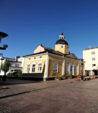
3. Kuressaare Town Hall. The baroque building, distinguished by its simple and austere forms, was built in 1670 on the initiative of a major Swedish nobleman, Count Magnus Gabriel de la Gardie. The original form of the town hall was restored in the 1970s. There is a gallery, a tourist information center and a restaurant in the basement.
4. Excellently restored Old Town, built in the 17th-19th centuries. The center of Kuressaare, which has many sights, is one of the most beautiful in Estonia.
5. The city park, founded in 1861 on the site of a wasteland around the Kuressaare castle and the old church garden, spread over more than 17 hectares.
6. Vilsandi National Park is of international importance and the highest category of bird nesting reserve. Its predecessor, founded in 1910, was the first nature reserve in Eastern Europe on the Vaika Islands. Tens of thousands of seabirds stop, feed and nest on Vilsandi and other islands.
7. The Harilaid peninsula, which is part of the Vilsandi National Park (the area is 3.62 km 2 , has been protected since 1924), is characterized by a diversity of flora (over 300 species). There are many gray seals in sea waters in summer, and rare sea birds in winter. The Tagamõisa peninsula has an interesting geological structure and rich vegetation. About 600 species of plants grow in the local alvars, lakes, lowland marshes, meadows and coastal dunes, including rare orchids, yew, ferns (spear-shaped multi-row), etc.


8. Viidumäe Nature Reserve (1873 ha) was founded in 1957 to preserve relic plant species and communities. Here grows such an endemic plant as the Esel rattle, which is found only in Saaremaa, ashy rowan, rare alpine clover and others. The two-kilometer study trail, which starts in the center of the reserve, can be walked under the guidance of a guide.
9. Lihulind settlement, covering an area of 2 hectares, is surrounded by 6-8-meter earthen ramparts. This strongest and best-preserved hillfort in Saaremaa is located away from the villages, in the forest, on sand dunes and surrounded by swamps.
10. Windmills in Angla the most famous in Saaremaa. The village mills were built on the hill. In 1925, when there were 13 farms in Angla, there were nine windmills. Four of the five remaining mills are typical of Saaremaa and were built at the beginning of the 20th century. The fifth (highest) is a Dutch windmill built in 1927.
11. Karja Church of Katariyna- the smallest medieval temple in Saaremaa. Built in the XIV century, the church has been preserved almost in its original form. Worthy of attention are the partially lost decorative wall paintings, magical signs on the ceiling vaults, unique fireplaces in the sacristy and in the choir stalls. Pilgrims who traveled from Scandinavia and Gotland to Estonia stopped in the church.


12. Yugu cliff is the most beautiful on the island of Muhu. It is located on the northwest coast, a little further from the modern coastline. The length of the coastal ledge is about 300m, the height is 12m above sea level.
13. The church on Muhu Island was built in the 13th century. Three volumes of the church - the longitudinal building, the choirs and the completion of the choirs - have an extremely steep roof. The church has no spire.
14. The windmill in Eemu, built on the site of an old windmill, has been open as a museum since May 17, 1980. Small windmills, typical of Western Estonia and the islands, are a unique phenomenon in farm architecture. Similar mills were built in Scandinavia and Western Finland.
15. The village of Koguva, the best-preserved village ensemble in Estonia, has about 100 buildings and about two dozen permanent residents. Village streets with stone fences, thatched log huts, wells and centuries-old trees create a unique atmosphere. The buildings in the village of Koguva belong mainly to the years 1880-1930. The oldest building, the barn of Andrusovsky Farm, is located in the center of the village. It was built with a single tool - an axe. The center of the village is Tooma Farm, the home of the famous Estonian writer Juhan Smuul.

16. Pangas Cliff the highest of the coastal ledges of Saaremaa and Muhu. The maximum height of the scarp is 21.3 m, its length is 2.5 km. At the highest point of the cliff there is an ancient altar, where in ancient times sacrifices were made to the sea.


17. The church in Valjala is the oldest building in Saaremaa, dating back to the 1st half of the 13th century. The church was built in Romanesque and Gothic style. Numerous fragments of archaic burial grounds are found in the stonework of the spire. Such ancient burial grounds were found only in Western Estonia.

18. The Koigi bog covers an area of 3980 ha and is the only one of its kind in the northwestern Estonian archipelago. A hiking trail has been laid through the swamp, which is distinguished by its diverse flora and fauna, and you can admire the beauties of nature from three observation towers. The thickness of the peat bog here is 3-4.5 m. Popular rumor says that Lake Koigi, the largest of the surviving relict lakes, was formed in the place where the owners of the Kareda and Koigi estates quarreled.
19. Meteor craters in Kaali in the central part of Saaremaa - a landmark not only in Estonia, but throughout Eurasia. Around the largest crater, 110m in diameter and 16m deep, there are 8 more craters. Kaali meteorite, which fell to Earth about 7500 years ago, the last giant meteorite to fall in a densely populated area.
20. The picturesque Wyatt Peninsula with shallow bays, reed beds, a diverse flora, is inhabited by many species of birds. Many species of orchids are found in the coastal meadows and in the reed beds; flocks of gray geese, geese, and cranes stop here in spring and autumn.
21. The oldest lake in Saaremaa, Karujärv (Bear Lake), was formed about 8,000 years ago. It occupies an area of 330 hectares, its greatest depth is 6 m. There are five islands on the lake. According to an old legend, the lake was called the Bear Lake due to the fact that seven bears clashed here. To separate them, God sent such heavy rain that a lake formed. The bears fled in their own direction, and seven bays formed on the lake.
22. Ruhnu Island (area 11.2 km 2 , population about 60 people) is the most remote Estonian island. It is only 37 km from Cape Kolka on the coast of Latvia, and 70 km from Kuressaare. The first mention of Rukhnu dates back to 1341. The bishop of Courland gave freedom to the local Swedes and allowed them to engage in agriculture. Ruhnu Stave Church, built in 1644, is one of the oldest wooden buildings in Estonia. Ruhnu has one of the deepest boreholes in Estonia. The water rising from a depth of 787.4m has healing properties and is very salty. Many rare and protected species of plants and animals can be seen on the island.

23. Sõrve peninsula deeply protrudes into the Irbensky Strait. At the southern tip of the peninsula, you can see a lighthouse from 1960, and next to it, the remains of a Russian coastal battery from 1914. A little to the side, in the forest, are the remains of another coastal battery, already Soviet, 1941.
24. Ruins of the order castle in Maasilinna. The ruins are covered with a capital roof and are being restored.
25. Peide church XIII century. One of the oldest churches in Estonia. A very impressive building.
Saaremaa (Est. Saaremaa, Swedish. Ösel, the former name in the Russian Empire - Ezel) is the largest island of Estonia and the Moonsund archipelago. Area - 2673 km². Its Sõrvesäär peninsula is the northern border of the Gulf of Riga. The fourth largest island in the Baltic Sea after the islands of Zeeland, Funen and Gotland. Administratively, it is part of Saaremaa County.
In the Old Norse sagas, Saaremaa is known as Isl. Eysýsla (Eysyusla), from the isl. eu "island" and isl. sýsla "county". Hence the German and Swedish name of the island - Ösel (German and Swedish Ösel). Estonian names. Saaremaa and Fin. Saarenmaa means the same, literally - "island land". The existence of the old Russian name-tracing paper "Ostrov" is indicated by the mention in the letters of the title "biskup Ostrovsky" - "bishop of the island of Ezel". Another name for the island - the island of Rusel is found in the middle of the 17th century in the notes of the Dutchman Nikolaas Witsen "Journey to Muscovy".
I have come across this wonderful island several times already, the first time in mentions of meteorite craters .... yes, yes, there are also craters here, and as many as eight pieces (!), The second time I was looking for material about star-shaped fortresses of the time of Peter. So I decided to take a closer look at this island and it turned out that this is a godsend !!! On the outskirts of the empire in little Estonia, it turns out they couldn’t wipe everything correctly and the contradictions are striking !!!
The word is the official point of view ....
....Archaeological finds indicate that the island was inhabited at least 5000 years ago. The sagas mention numerous skirmishes between the inhabitants of Saaremaa and the Vikings. The island was the richest land of ancient Estonia and the base of Estonian pirates, sometimes called Eastern Vikings. The Chronicle of Livonia by Henry of Latvia tells about their fleet of 16 ships and 500 people, devastating the lands in the south of modern Sweden, at that time (XII century) Danish. In 1206, King Valdemar II of Denmark landed on the island with an army and made an unsuccessful attempt to establish a fortress there.
Independence ended for the islanders in 1227 with the conquest by the crusaders and the formation of the Ezel-Vik bishopric on its territory. German sovereignty ended in 1559 when the island was sold to the Danish king. In 1645, Saaremaa passed into the possession of Sweden for more than half a century. In 1710, during the Northern War, the troops of Peter I conquered Saaremaa and the island was annexed to Tsarist Russia....
I will continue to give official information and back it up with photographs. Let's start with the capital, decorated with the bishop's castle and, as they say in the guidebooks, "fortifications with a moat" - a classic star-shaped fort. On the satellite map, the fortress is clearly visible, but also the canal that comes from the sea and, as it were, even has walls .... why it is not clear! The depths there are the same around ... but it obviously ends on a cliff in great depth. There are similar canals in the bays in St. Petersburg and Venice, and in many other places, for example, at the mouth of the Volga and the Urals
Again I give the floor to the officials ...
...The main attraction of the city of Kuressaare, and, perhaps, of the entire island of Saaremaa, is the medieval episcopal castle. Its history began in the 13th century and continues to this day. It is worth noting that Kuressaare Castle is the only building in the Baltics that has not undergone significant changes over the years. The ancient fortress stands in the center of the city, surrounded by a deep moat filled with water. Its walls still look impregnable. Dolomite, which is considered one of the symbols of the island of Saaremaa, was used as a building material for the castle. The distinctive features of the Kuressaare fortress are stylishness, austerity of architecture and majestic beauty. Unfortunately, the exact start date for the construction of the main castle of the island of Saaremaa has not been established. It is assumed that the laying of the fortress took place in 1322-38, during the reign of Bishop Jacob. The first written mention of the castle dates back to 1381. It is believed that the laying of the complex began with the construction of the Long German tower back in the 13th century, around which other buildings appeared over time. Kuressaare Castle was originally planned as an administrative center where meetings could be held and at the same time withstand a siege in the event of an enemy attack. Before the start of the Livonian War, the fortress was also used as the residence of the Ezel-Vik bishops. In 1559 the castle was sold by Bishop Johannes V Munchausen to the Danes. In addition, other episcopal possessions in Saaremaa were attached to it. The Danish period of ownership of the fortress was marked by the modernization of the fortification system. Using the old fortress wall, the new owners built a system with thick earthen ramparts and bastions, which was surrounded by a moat 30 meters wide, which was filled with sea water. Actually, in this form, the fortification appears to the eyes of travelers today. In 1710 Kuressaare Castle became the property of the Russian Empire. However, it was not used as a defensive fortress during the period of Russian rule. Moreover, in 1783 the convent house Kuressare (this is another name of the fortress) was generally excluded from the list of defensive structures, and after the capture of Finland by the Russian Empire, it completely lost its reference value.
Source: http://triptoestonia.com/dostoprimechatelnosti-kuressaare/episkopskij-zamok-kuressaare/
Well, it would seem that everything is simple and natural, but .... let's take a closer look at these certain ditches and bastions ... 

For some reason, these gates reminded me of all sorts of punka and pikchi, but what about similar buildings! And they are all different, they didn’t have a ruler or something ???


The classic world fortress is a star, the construction of which is attributed to the 18th century. That is, we are offered to believe, fools, that first they built the bishop's castle in the 14th century and then some Danes erected bastions around it .... well, of course, anything can happen ....
Now we need to consider the castle itself.


Take a closer look at the masonry of the castle walls - I would call this masonry transitional from polygonal to mortar masonry. The stones are all different, hewn and fitted to each other even with elements of polygonalism ... but they lie on the mortar, so they are not perfectly hewn, it is not necessary when there is cement! By the way, it is on this island that dolomite is mined - a kind of limestone, the castle is laid out of it ... and right here, on the island, it was burned and sold in the district.
But the builders of the bastion didn’t bother with this garbage yet, they built it the old fashioned way - they cut a stone, drove it, took a dollar, paper of course, Sklyarovsky, and if he didn’t climb between the stones, then they laid it in the walls !!!


Not only that, the ancient builders also carried out earthworks to dig this whole story with a 30-meter-wide moat, built canals throughout the island and many other interesting things can be seen from the satellite ... in general, on this island you can defend more than one doctoral dissertation on alternative history: -)))
But someone really, really didn’t like all this splendor, like everywhere else on earth ... there is only one fate - funnels! There are already nine of them on this island! Scientists argued and argued for a long time and decided to consider them meteorite ... well, what else!
Kaali (est. Kaali kraater) is a crater formed as a result of a meteorite fall on the island of Saaremaa in Estonia. The meteorite crater lying 18 kilometers from Kuressaare in a forest near Kaali is surrounded by an earthen rampart 16 meters high and 110 meters in diameter. In addition, there are eight smaller craters in the district, from 15 to 40 meters in diameter.
The explosion threw dolomite rocks out of the main crater ... (that's what a bad explosion !!!)
The meteorite that fell probably 4 thousand years ago, of course, is not mentioned in Estonian chronicles (well, of course, this is a song ... Estonian chronicles ...), however, its fall, presumably, was captured in Estonian runic songs (it's like can you sing with runes???) and left a mark in Finnish and Swedish legends. However, among the local population, there are still legends. So, according to one, the earth swallowed up the church in this place, in which the brother and sister got married. According to another version, after an unbridled orgy, the earth swallowed up one landowner along with his estate and company at this place ... (well, just Sodom and Gomorrah) ....
In the 18th and 19th centuries, hypotheses of a volcanic eruption and a prehistoric water reservoir emerged. Finally, in 1937, geologist I. Reinwald discovered the charred remains of a tree and fragments of a meteorite with a nickel content of 8.3%, which became clear evidence of the fall of an iron meteorite .... Well, at least stop, even fall .... found a charred tree - well everything is clear ... a meteorite, of course, they always fly with trees! ....
Further research completed the picture. So, it is assumed that a meteorite weighing from 400 to 10,000 tons entered the earth's atmosphere from the northeast at a speed of 15 to 45 km/s, and, losing mass due to atmospheric friction, broke up into several fragments at a height of 5-10 km. The largest fragment weighing 20-80 tons and a speed of 10-20 km / s formed a large crater, eight smaller ones were the result of the fall of the remaining fragments. Included in the top ten "best" craters of the earth: http://diletant.ru/articles/35295/?sphrase_id=1395087
Something I am tormented by vague doubts about these meteorites, especially taking into account Chelyabinsk .... it, of course, may have flown a stone, but who launched it? Question!!!


What the tour celebrates. guidebooks, everything on the island has been preserved untouched, everything is so natural ... funnels even stood like new for 4000 years, all sorts of mills and houses with thatched roofs.
Even clocks for public use .... whoever argued with me about clocks in ancient Rome and so on, come to Saaremaa ... everything is as good as new, Estonians are thrifty people!

This is the sixth funnel that has stood well for all 4000 years ...

And here are the houses of the common people ... modestly, not everyone has a stove ... although there are up to hell and more stones around ... straw on the roof.


Here are such funny stops ... well, think about polygonal masonry ... there are probably a lot of them left in Estonia ... not bombed!

Look how lovingly all 4000 years they dug and preserved, singing runic Estonian songs, these funnels... how they knew that they would get into the top 10! I think that there were more funnels there ... they smelled when the Soviet government gave tractors.


But this “fun” of the bishop was preserved in the castle and, judging by the brilliance, they threw it around quite recently ... or maybe they didn’t leave it at all ... oh, these Estonians are Europeans, they will call new meteorites at us ... on top there everything is visible.