The mountain did not let everyone in: climbing Elbrus from the north, report. Climbing Elbrus from the south - report Elbrus independent climbing report
Members: Katya (Krasnaya Polyana), Sanya (Adler), Roma (Maikop), Vadim (Yekaterinburg), Daniil (Monchegorsk), Dmitry (Murmansk) Route thread: Mineralnye Vody - the village of Khurzuk - per. Balk-Bashi - plateau "German airfield" - northern parking - Eastern peak of Elbrus "- northern parking - glacier Dzhikaugenkyoz - per. Irik-Chat - the valley of the river. Irik - pos. Elbrus - pos. Cheget - Prokhladny
Our journey, the purpose of which was to climb Elbrus, began in Mineralnye Vody, where all the members of our team arrived from different cities of Russia: from Adler to Yekaterinburg. We loaded into a pre-ordered minibus and drove off. The whole organizational part was handled by Katya, who ordered a transfer from the Mineralnye Vody to the village of Khurzuk (+79283475869 Vladimir, the cost of a minibus for 6 people is 6000 rubles).
We arrived in Khurzuk at 12.45. Here catches "Megaphone". They called the Ministry of Emergency Situations, got registered - 8-866387-14-89 Ministry of Emergency Situations of the KBR, Terskol, 8-86638-7-12-32 Tiolv Boris Osmanovich - beginning. PSO Terskol.  The locals came up to us and greeted us. They helped us find a car to pick up on the mountain road. We got into the UAZ (Sashok - UAZ from Khurzuk to Dzhilysu, 3000 rubles) and already at 15.00 we were at the confluence of the Ulu-Khurzuk and Bitiktebe rivers at the mineral springs on Karachay Dzhilysu. Having climbed the path for another kilometer, we set up our first camp (N 43°24´04.1´´ E 042°21´28.8´´).
Approach to Elbrus: winter in summer
In the morning, the entire grassy-scree slope was covered with snow. Visibility was low. There was fog.
After breakfast, we decided to explore and walk along the path towards the Balk-Bashi pass, aka Palbashi (N 43°23´33.2´´ E 042°24´11.2´´). Having walked, we realized that the path is quite visible under the snow. We returned to the camp, thoroughly refreshed ourselves and at 11.45 advanced to the pass - 3700 m, 1 "a".
 The ascent took 5 hours.
Description of the ascent to the Balk-Bashi pass from Bitiktebe
The path from the river immediately goes uphill to the left spur, crosses a shallow stream and steeply gains height, goes to the middle of the ridge and goes along its tops to the very pass. Thus, the exit to the pass is, as it were, on the left, from the ridge. The descent is straight down, steep at first, then flattening begins. From the slope you can see a puddle (overflowing stream) and places for parking at an altitude of 3600 m.
When lifting the snow it was ankle-deep, on the pass it was clear - the snow was blown away, and on the descent it was knee-deep and higher.
There were already groups at the campsites under the pass. We approached, got acquainted, set up our second camp (N 43°23´32.8´´ E 042°24´30.3´´).
Snow fell all night.
 One of our tents, the four man Red Fox tent, sagged and buckled under the snow due to the design. I had to get out every 2 hours and shake off the snow cap from it.
Here is the morning. Some participants felt the first signs of mountain soup and refused breakfast. We packed up and left the camp at 8.40.
 Let's go down. The trails were not visible, we walked on the GPS knee-deep in snow. Below the snow became less and a path appeared, which led us to the tundra plateaus. The snow is over.
We crossed a rather turbulent river. After the crossing we had lunch. We went out onto the road going along the steppe plateaus to the Dzhilysu valley to the springs, but we had to go to the German airfield.
According to the descriptions of those who climbed Elbrus, whose report we read in preparation for the trip, somewhere there should have been a turnaround to the “German airfield”. It seems that we did not reach it and, on the recommendation of a local shepherd, who was overtaking us on horseback, turned off earlier and walked across the field. The field turned into a slope, then into a very steep slope. We had doubts, thinking that we had been sent incorrectly and were already about to turn back, when suddenly we stumbled upon a path in the grass, winding a traverse and smoothly dropping height, which led us to a raging stream.
Having crossed the stream, she led us up between the rocks of the lava flow and finally led us to a huge plateau with tundra vegetation - the German airfield.
We crossed it and on the other side saw a well-filled wide path leading to the Northern parking lots and shelters from which the ascent to Elbrus begins from the north - to the Eastern peak. On this trail, at 2880 m, we set up camp (N 43°24´48.4´´ E 042°29´39.7´´) and spent the night.
 In the morning, the entire plateau was covered with snow, and at about 11 am groups went up the path from Emmanuel's glade to the Northern Shelters. At 11.50 we also moved up the path.
Description of the rise from the "German airfield" to the northern parking
Directly from the plateau, next to a falling, drying up stream, the trail sharply gains height. At the top of the slope, it bifurcates: to the left leads to the "mushrooms", to the right to Elbrus.
Along the right path, another sharp rise leads to a spur called the Gray Ridge. The trail goes along the ridge with a smooth climb, to the very top and leads to a snowy field, where it forks. The left one leads to the northern parking lots, the right one leads to the Oleinikov Shelter. Having crossed the field, you need to climb the stones of the lava flow behind them and there are the Northern sites and two kungs of the Ministry of Emergency Situations (N 43°23´17.3´´ E 042°28´39.8´´).
 We arrived at 15.20. Height 3780 m. We saw a lot of stone "nests" - places for tents. They occupied two - they stood up and looked around - the ascent path is clearly visible. At the Northern parking lots, Megafon catches, so they called back to their relatives. All are in good condition. We began to prepare for the ascent.

Useful articles:
Climbing Elbrus: from the north to the Eastern peak
On this day, an acclimatization trip to the Lenz rocks at 4700 was planned. In the morning there was a very strong wind, but still at 10 we went out.
 According to the description, the beginning of the ascent when climbing Elbrus passes through closed cracks. So we went together. We reached the first protruding stone, took a breath and moved on to the lower cliff (with tablets). It was difficult because of the height and strong wind. The slope itself is not steep and does not present any technical difficulty. Having reached the rock, they took a breath and went down. We were more exhausted than during a day trip with backpacks.
On this day, we decided to take a break. There was no wind in the camp, but you could see the snow blowing off the mountain. The climbers who made an attempt that day did not climb Elbrus because of the strong wind on the mountain. And we rested: ate, slept, etc. The exit to the mountain was scheduled for 2 o'clock in the morning.
Storm. Wake up at one in the morning, breakfast. Departure at 2.30 (late). Lanterns are already visible on the slope. This time we reached Lenz in a little over two hours and were not even tired.
Having bypassed the lower rock, on the right we went between the remnant rocks sticking out here and there. The slope became steeper, we passed by the kung (4820 m) (N 43°21´49´´ E 042°27´51´´) - a landmark place that saved many lives when climbing Elbrus, reviews of which we have repeatedly read.
At an altitude of 5000, the height began to be strongly felt. Hands and feet got heavy. The Lenz rocks remained at the bottom, and an endless snowy rise appeared ahead, resting against the sky.
But step by step, and against the background of the blue sky, small stones appeared. The eye clung to them as a goal. We approached them, GPS showed 5620. It seems that this is the top, but no - this is the edge of the crater. From here one could see the path and the chains of people going to the Western Summit and the Main Caucasian Range and all the mountains and valleys surrounding Elbrus.
 It is necessary to go around the edge of the crater on the right and reach the tour, for which I no longer had the strength. The guys approached the tour at 11, took pictures at an altitude of 5621. I waited for them at the rocks.
Down went easier. From the slope it was clear how huge Elbrus is, the mountain that has been climbed since the 19th century. Having reached the lower cliff, we rested, contacted and went to the camp. The last meters seemed especially difficult, they arrived at 16 o'clock.
Useful articles:
Through glaciers and moraines
In the morning we had breakfast and at 11.15 we left the Northern camps.
 We climbed 100-150 meters up to the neighboring moraine, caught a path and went down along the edge of the Michelchiran glacier to its lower edge, to Dirty Lake.
 At 17.00 we went to the confluence of two rivers at an altitude of 3045. We crossed them, caught the path leading to the glacier. Jikaugenkoz and went along it. We planned to stand on the lake (sometimes called Izumrudny) 3324, but slipped through and went to the moraine leading to Kalitsky Peak.
 We stopped almost under the peak on the madder and set up camp at 19.20 (N 43°22´22.0´´ E 042°32´29.7´´).
In the morning there was no visibility and a strong wind was blowing, we decided to wait. The fog began to inflate and at 10.30 we went through a huge ice field to the Irikchat pass. We walk along the Jikaugenkez glacier in bundles and crampons.
Cracks are clearly visible. A strong wind is blowing with grits. After the meeting, we decide to approach the pass. Closer to Irikchat we find a path.
 We start climbing at 12:25. A strong wind knocks you off your feet. Constantly crossing cracks. At 13.10 we are at the Irikchat pass 1 "b" 3667m (N 43°20´46.4´´ E 042°32´17.8´´).
Description of the passage Irikchat from the side of the glacier
The pass is snowy on the western side. In the lower part there are closed cracks that pass in the bundle. It is better to climb the pass along an oblique from right to left, go to the pass point on the left. There are places for parking at the pass. The descent of talus of stones and clay should be kept to the left side, in the direction of downward movement, there is a path.
At the pass we met groups from the Czech Republic, Slovakia, Belarus, who were going down Elbrus from the route along the Achkeryakol lava flow.
We went down the path that goes along the sypukh, went out to the green. The trail wound along the shore, with tents camped here and there. Then the path began to lose height sharply and led us to the confluence with the right tributary. The first pine trees appeared, and a waterfall rustled to the side. Here we set up camp (at 18.00), it began to pour rain, which went on all night.
In the morning the weather improved, we slowly hung things out to dry, ate, packed up and went along the 7 km path through the meadows and woodlands.
 We went out to incredible sandstones, traversed them and went down to the village of Elbrus, where a gazelle was waiting for us. She took us to the village. Cheget.
 Here we spent 3 unused spare days at the Zapovednaya Skazka base (Abu 8-928-704-40-36, lived in houses 200-250 rubles per person plus 50 rubles for using a shower, the same in Terskol costs 500 rub per person and above). We ate kebabs, rode the cable car.
August 8 (13 day)
We loaded into the "gazelle" and left for Prokhladny (2500 rubles for all).
Dmitry Ryumkin, specially for Zabroska.rf
Not having time to arrive from friendly Georgia, where our group made, I was already looking forward to a trip to the highest point in Europe - Elbrus. At the same time, against the backdrop of a simply impeccable past trip, there were certain thoughts - well, what will I find beautiful in a place where I am not the first time, where there are a lot of tourists, where ski lifts, snow groomers, snowmobiles, shelters take away the last bits of freedom from people who have come to test themselves, the pleasant difficulties of climbing and a real climbing bivouac? At least we didn't plan to use aids above 3500 meters.
Also, good acclimatization and regular uphill training are important for success, preferably with a heavier backpack. We planned to get all these joys in the first part of our trip - mountain trekking near the village of Verkhniy Baksan.
Day 1-2 [/]
So, I met at the station in Pyatigorsk with a group on July 1. First of all, Dima arrived from Voronezh. We already knew each other from previous trekking in Montenegro and were delighted to have the opportunity to go to the mountains together again. To celebrate, we managed to buy food and gas even before the official gathering time of the group, as well as take a little walk around Pyatigorsk. Our group consisted of 5 participants and a guide, i.e. me. Five men and a girl. Not everyone had the experience of climbing in the mountains, but everyone was quite well prepared physically, and - just fine - mentally. A very good number of people for a trip like this. From the very first hour, an excellent atmosphere of camaraderie, humor, and healthy sporting ambitions developed in the group. Not once during the trip did we have any conflicts, no one spoke in raised tones with each other. I ordered a transport by phone, which delivered us from Pyatigorsk to Verkhny Baksan on the same day after lunch.
Trekking. We were able to warm up on a very beautiful route that passed through the valleys of two rivers - Syltrans and Kirtyk, and included an overnight stay near the mountain lake Syltrankel, the conquest of the Syltran pass and an easy radial exit to the ridge without backpacks.
On the first night, we only slightly rose above the village and spent the night in the sight of the Baksan River near, as a local resident explained to us, a miraculous spring where water containing silver enters a banal metal bath. Evening by the fire, conversations, acquaintance, first night in tents. For many, this was the first night under the stars outside the city in a very long time.

On the second day, the participants had to demonstrate all their stamina, endurance and strength - after all, with heavy backpacks, we had to gain almost one and a half kilometers of height along a rather difficult terrain. The trail first passed through the forest, we often crossed streams. Then we went to the mid-mountain zone with its amazing vegetation of dwarf trees twisted by the winds, thickets of radodendron, wild flowers and herbs. Sometimes I had to move along the stone placers, balancing with a heavy backpack on poorly standing stones. As we climbed, snowfields began to appear, the vegetation began to disappear. After many hours of a difficult but extremely beautiful journey, halts and snacks, losing the path in the snowfield and my reconnaissance wandering along the stone scree slope, we nevertheless reached an altitude of 3200m, where an amazingly beautiful view of the lake opened before us. Ice floes were still floating on it, on the slopes of the mountains surrounding us lay strips of melted snow, on the higher peaks - caps of glaciers. In this place, a person is embraced by an indescribable mood and state. We set up camp on the very shore of the lake. At such a height it was already quite cool and windy, especially in the evening, so we had to dress properly and strengthen the tents with stretch marks. It also turned out that this place is a favorite habitat for mountain goats, which walked around in whole groups, sometimes approaching a couple of tens of meters.

In the morning, we did not deny ourselves the pleasure of swimming in an icy lake, and after a rather long gathering and visiting a viewing point above the reservoir overlooking the yesterday's valley of the Syltransu river, our group began to climb the Syltran pass. The height difference here is small and the climb did not take all our strength, but it brought a lot of joy - the views from there are amazing, the landscape is simply alien! After a short rest on the pass, we began to descend into the valley of another river - Kirtyk, along which we had to return back. The descent was not an easy task for many. In the mountains, the descent can often be more difficult than the ascent. In some places he was very cool, we had to carefully take every step and help each other. Nevertheless, after some time, we ended up in a new valley, where it was decided to set up camp at an altitude of about 3050m and arrange a half-day with a radial exit.


We chose one of the ridges closing the “circus” of the Kirtyk river valley as the object of our mountain excursion. After a short but very steep ascent along a scree slope, we found ourselves on a ridge. It was so beautiful there that no one wanted to go down. As a result, we sat on top for about two hours, admiring the panorama of Elbrus and the surrounding mountains. Nevertheless, in the late afternoon, we went down to our camp and started preparing dinner.

In the morning we allowed ourselves to take a little walk and sunbathe, after which we packed up the camp and moved down the valley towards Upper Baksan. Gradually lowering the height, we admired the views and had conversations with our neighbors along the trail. We spent the night already somewhere at 2300, on the high bank of the river. We collected a lot of firewood, so in the evening we could sit around the fire to our heart's content. In the same fire, Dima's socks disappeared without a trace ...)


On the last day of trekking, we could not allow ourselves to sit for a long time - we had a very rich program ahead of us. Therefore, we left early and after a couple of hours went down to the village. Before we had time to eat ice cream, our driver drove up. First, we stopped at the village of Elbrus, where we bought the products necessary for the ascent in the store. Then we went to the turn to the Cheget glade, where in the well-known box office for an hour and a half they picked up the missing equipment. After consulting with local guides, it turned out that ice was exposed on the western peak and special equipment was needed to overcome the dangerous area. I had to take it too. The rental is quite expensive, but there is almost everything you need for entry-level mountaineering.

Climbing.
The driver patiently waited for us and took us to the final destination - the village of Azau - the highest inhabited point of the valley. From here they begin their ascent of the cable car to Elbrus. This village is simply imbued with the spirit of Elbrus, it is everywhere - in names, souvenirs ... it has become part of the mountain and exists at the expense of the mountain. Here a farewell flat lunch was given in a cafe, thanks to which we almost stayed downstairs longer than expected - the cable car closes at 16:00, and we stayed until 15:50)). Twenty minutes, and we have already risen from 2300 to 3500. It's cooler, fresher. You can go further - on a chair lift to the "barrels", at 3800. But for the sake of better training, we go on foot. At 3800 our lodging for the night - we find a good place for tents on a stone ridge along the road for heavy equipment - something is being built here all the time, hefty trucks and other mastodons drive. Now they are installing supports for the next cable car. As always, they spent the night mentally.


In the morning we moved on - climbed to a height of almost 4200, to a place known as the "Shelter of Eleven", although this shelter burned down seventeen years ago. Now there are a lot of trailers on stone screes. In addition, there are tents. We also camped in tents, found good grounds above the KSS trailers.

Nothing compares to the feeling of living at high altitude, above the clouds, in the shadow of a huge volcano! On such days, I feel like some kind of bird, an albartos wanderer, who has made a temporary nest somewhere on the edge of the world in order to rest and fly further. We lived in our camp for four incomplete days and three nights and to some extent managed to get used to these heaps of stone, a world without greenery, with a bewitching view of mountains, glaciers, snow, changeable weather. We managed to catch this simple mountain rhythm with early lights out and early rises, to feel this bird weather dependence - here we are subordinate to the sun and fog, snow and rain, wind and sun. But the Mountain was waiting for us and calling to itself. When you see her every time you raise your eyes, you eventually learn to see her even through the night or through the veil of clouds.

Therefore, on the second day of our "bird" life, we went higher, already without heavy backpacks. For acclimatization, we, as usual in these places, climbed to the top of the Pastukhov Rocks, where we safely got into a snowstorm. We were covered in snow, visibility was gone up to several tens of meters, and we were sitting just like six tightly dressed Alice in the White Wonderland ... at such moments I lose touch with what is commonly called reality ... Early July? Heat? Ice cream and the beach? We are in the snow up to the top and shifting from foot to foot so as not to freeze! Then we went downstairs, warmed up, rested. Some of us experienced what an attack of mountain sickness is - weakness, headache, many were driven into a tent. The weather forecast for the next day was not good. We agreed to have one more acclimatization hike and rest before climbing Elbrus. At the same time, we agreed that we would look at the weather.

Vertex.
And the weather again brought a surprise. At four in the morning there were no clouds above us, it was quiet and Elbrus simply attracted us with the purity of its outline. We began to pack up, although not all of us were physically ready to go up. The disposition was as follows - we put on "combat style", put on harnesses, take tea, food and go up. Further on the circumstances. This will either be another way out for adaptation, or perhaps an attempt at an assault. Although personally I did not really believe in this possibility. Firstly, in the alpine camps it was firmly drummed into my head that they don’t go to Elbrus so late, and secondly, the condition of not all participants was pleasing to the eye. Nevertheless, we went out in full force at six in the morning. Unfortunately, one participant immediately felt ill and returned. The rest continued to rise. Here is the place of yesterday's highest point for us ... We take a short rest and go higher. We reach the last frontier of civilization - this is somewhere at 4900, a place where snow groomers and snowmobiles reach. Then the infamous “oblique shelf” begins - in fact, this is an oblique traverse of the eastern peak with a constant climb. It is already difficult for an unprepared climber to go here. Gradually, the intervals between rest stops began to decrease, the group began to slow down, but still climbed quite confidently. Finally, we reach the traverse, and, having passed between the peaks, we get to the place of ascent to the Western, the highest. Occasionally, people come down to meet. Their appearance can give confidence to few people - most are exhausted, make frequent stops, sit down on the snow. But, as I already wrote, it was difficult to shake the morale of our group with such trifles)). We begin the steep ascent to the Western Peak. Thanks to the ascents made in the season (and twice), I feel pretty good, I watch the guys. Someone is doing well, someone goes free, but everyone goes and no one complains. I admire and move on. Here is the beginning of the railing. We go separately, with self-insurance. Even for a novice climber, this section is not difficult, but what should an ordinary city person feel here, sitting in his office a week ago?! It's hard to even imagine… One by one, having passed a steep rise, we reach a gently sloping summit plateau. And now, in another thirty minutes we reach the top! Three PM. The weather is calm, cloudy, almost nothing is visible. And yet we are here! On the top! There is no one here but us. The highest point in Europe is at our complete disposal for almost an hour. Someone laughs, someone silently rejoices. Feelings are unreal. Something happened to us that many of us realize in detail only after days and even months of life. In the meantime, we are all here celebrating our small victory together! Our team was able to achieve their goal. Almost by force after forty minutes I force the descent to begin.

Surprisingly, but the summit added strength and vigor to almost everyone. On the descent, our group looks better than many others - we do not stagger, we do not fall on the trail in search of peace. We confidently go down. If the ascent took us about nine hours, then the descent took a little more than three. We go down to the camp, rest. A friend who refused to climb prepared tea for us, brought barbecue from a cafe. We eat dinner and rest.

In the morning we begin to gather a little. Closer to dinner we go down to the ski lift at 3500, from there to Azau. We go to Cheget and rent equipment. Here two participants leave the group and rush by minibus to their trains.
There are still a few days ahead that we spent traveling around the Caucasus, swimming in narzan, tasting local cuisine, going up the lift to Cheget.

This trip as a whole brought me a lot of vivid and varied sensations, useful experience and incomparable pleasure. I sincerely thank all the participants of our trip for their participation, good mood, cheerfulness and willpower! See you on the way!
|
Type of Tourism |
Length active part hike, km |
Maximum height, m |
Maximum overnight stay, m |
Duration |
Running days |
Dates |
|
|
mountain tourism |
Journey with 3rd class elements |
28.04.2013-04.05.2013 |
Claimed
station Gara-Bashi - shelter Eleven - Pastukhov rocks - per. Elbrus saddle + ver. Elbrus B + ver. Elbrus Z. (2A, 5642 m) - Pastukhov rocks -
Actual:
Moscow - Mineralnye Vody - pos. Terskol - station Stary krugozor - station Mir -
station Gara-Bashi - shelter Eleven - Pastukhov rocks - per. Elbrus saddle + ver. Elbrus Z. (2A, 5642 m) - Pastukhov rocks -
Shelter of Eleven St. - Gara-Bashi - station Mir - pos. Terskol - Mineralnye Vody - Moscow
Passed obstacles2A 1 pcs: per. Elbrus saddle + ver. Elbrus Z.
Group contact information:|
№ p.p. |
Full Name |
Experience |
Responsibilities in the group |
|||
|
Tilman Yuri Alexandrovich |
1SU (Sayan, 3-1A, 1B, 3500m), 2GU (Altai, 8 - 1B, 3560m), 4GU + hands. LP 1B (Fanskiye Gory, Gissar Range, 2-1B, 2A, 4-2B, 4740m), 1GR (Northern Tien Shan, Zailiysky and Kungei Alatau, 3-1A, 4172m), 2GR (Aladaglar, 2-1A, 3 -1B, 3208m),3GR (Dzhungarsky Alatau, 5-2A, 4-1B, 3735) |
Head Medic |
||||
|
Grashin Konstantin Stanislavovich |
2SU (Aladaglar, 2-1A, 3-1B, 3208m),3GU (Dzhungarsky Alatau, 5-2A, 4-1B, 3735) |
Gear Remmaster |
||||
|
Osipova Svetlana Alekseevna |
1SU (Northern Tien Shan, Zailiysky and Kungei Alatau, 3-1A, 4172m), 1GU (Elbrus region, 4-1A, 3520m), 2GU (Kavkaz, Gvandra, 1-1A, 6-1B, 3546m),3GU (Dzhungarsky Alatau, 5-2A, 4-1B, 3735) |
Financier The trip plan was changed immediately upon arrival in Terskol due to the weather forecast. The forecast was favorable only for the first 5 days of the trip. To save time, we decided to go directly to Mir station instead of Stary krugozor station and go radially to Gara-Bashi station. We went up to Shelter 11 and set up camp there. Radially climbed 250 meters up, instead of climbing to the Gara-Bashi station and radial exit to Shelter 11. As planned, we descended to the Pastukhov rocks, but not from the Gara-Bashi station, but from Shelter 11. Since it was not possible to rest on the night of April 28-29 due to the height, we lowered the camp to the Mir station. From the Mir station we climbed radially to the Pastukhov rocks, then descended to Terskol on the same day. We drove by lift and snowcat to the lower cliffs of Pastukhov, reached the upper cliffs of Pastukhov, where we set up a camp, instead of setting up a camp at the Gara-Bashi station, which was due to the fact that May 4, according to new forecasts, was an extremely favorable day in terms of weather for climbing. Due to the fact that the weather forecast for May 5 was unfavorable, we refuse to spend the night on the saddle. We climb Elbrus Z., without going directly to the saddle. We refuse to climb the eastern peak, as we understand that on the same day we can fly home.
|
Elbrus is the highest mountain peak in the Caucasus, Russia and even all of Europe. The legendary giant, a huge block of ice, which I always wanted to visit. Every summer, climbing Elbrus was considered as one of the options, but was constantly postponed until later. At first there were native, Siberian Sayans, Baikal and Altai. Later - Kamchatka, Tien Shan, a month of hiking in the Himalayas, climbing Mont Blanc. Finally, after moving from Moscow to Sochi, I proclaimed for myself the "season of the Caucasus", highlighting the winter and spring campaigns in the Western Caucasus in the vicinity of Krasnaya Polyana. By the beginning of summer, it became clear that the physical form lost over the seven years of living in Moscow was more or less restored and the time for the Big Mountain had come!
UPDATE! On the May holidays of 2017, my friends and I climbed Elbrus from the south along the classic route. Read this story too.
Day 1. Transfer to the meadow of Emmanuel
It is not difficult to get from Sochi to the Elbrus region - you take a direct train in the evening and early in the morning you are already in Mineralnye Vody. As agreed, Yuriy was waiting for me on the platform. Clothing and a characteristic "spectacle tan" immediately betrayed an experienced tourist in him. We say hello, load my things into the trunk of the outdoor-pumped Niva, drive to the airport to pick up Artem and leave for the mountains!! Beauty is all around - the morning fog covers the tops of the laccoliths, scattered here and there in the steppe.
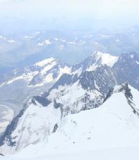
After a couple of hours of driving along the most beautiful road, we climb the spur of the mountain, which offers a postcard view of Elbrus from the north! According to Yura, the road has recently become much better. The mountain looks truly majestic from here: a huge two-headed snow giant dominating everything around! All the key objects of the northern Elbrus are at a glance: the Emmanuel glade, the sources of Dzhily-Su, the "airfield", the Northern Shelter, the Lenz rocks, Kalitsky peak.
Artem, Yura and me against the backdrop of the northern slope of Elbrus
We descend to the ford through Kyzylkol, a tributary of the Malka River. From here to the Dzhyly-su camp is only a few hundred meters. Yura decides to save the car and drops us off in front of the ford. We are not worried - there is still a whole day ahead, and today's program only includes a walk to the mineral springs. We negotiate the time when Yura will return for us after the mountain. This must be done in advance, since there is no mobile communication here anymore, it will appear only on the southern side of the Elbrus saddle or at the very top. (update 9/09/2012 - Megafon installed a tower in the camp at 3800, so now the connection should work in the entire northern Elbrus region!!!)
Yura leaves for home in Kislovodsk, and we, without even crossing the river, decide to have breakfast right by the shepherd's cat. We collect water directly from the river, which flows along a wide valley, where huge herds of sheep and cows graze. A little dumb, but the water was boiled and thank God there were no consequences :)
After breakfast, helping each other, we hardly climb under our 30-kilogram backpacks and make a short half-hour march to the camp. Backpacks, of course, are hellishly heavy - a powerful tent, a bunch of warm clothes, "iron" ... It's good that our entire short path runs along perfectly flat terrain, so, apart from crossing the river on a suspension bridge, there are no difficulties.
In the camp at Emmanuel's glade, life is in full swing - some are arriving, others are leaving, someone is preparing to go upstairs.
The height here is no longer small - 2600 meters, and the oxygen content in the air is already 1/4 lower than at sea level. So don't be in a hurry to climb. Our plan for today is to set up a tent, register with the Ministry of Emergency Situations and take a walk to the springs (active acclimatization is the most effective). The camp of the Ministry of Emergency Situations stands right on the clearing. A pleasant woman writes down the dates of our trip, the names of the participants and the contact phone number for contacting relatives in the log book if the group finishes the route on time. At the end of the trip, so that they don’t look for you, you must definitely call back and report that everything is OK.

After lunch we go for a walk to the springs of Dzhily-Su. The trail starts from the suspension bridge and goes along the right bank of the river, going down two hundred meters below our camp. It’s a little insulting and lazy to throw off the height, but nothing, extra acclimatization will not hurt. On the way we meet dozens of tourists. The people are motley: foreigners, Cossacks with flags, seasoned tourists. What to say about sources? Well, it's cool. Warm mineral water gurgles right from the ground. A bunch of locals (talked with a cool granny) go to these places every year for health. But we're still early! A little disappointed was the Sultan waterfall, located directly above the springs. Some nondescript, muddy water, didn’t even take pictures ... We spent three hours walking from the camp to the springs and back, a good warm-up!
By seven o'clock in the evening we return to the camp, and then the fun! The Cossacks celebrate the anniversary of the first ascent of Elbrus, made by General Emmanuel in 1829 (then they also climbed from the north). They covered the clearing, vodka flows like a river. They meet a Cossack with a huge backpack and a flag. Came down the mountain. One for all?? They pour, drink a lot and noisily, but without debauchery. Fun camp.
 |
 |
Camp at Emmanuel's Glade
It is worth noting several important points regarding the camp. The most important thing to know about Gila-soo's camp is that there is no cell reception here! So, as I said, you need to agree on the return transport in advance and for a certain time! There is, of course, an emergency option - the guides of some travel agencies that work along the route "Elbrus from the North" have satellite phones and, in principle, probably for a small amount of money, you can call from their phone. In a clearing, surrounded by a small fence, is the territory of a small commercial project called "Alpine camp Oslik". There is a real cafe, an outdoor shower and even the Internet. Menu - soup, second course, cola, beer! The truth is not cheap.

Northern slopes of Elbrus from Emmanuel's glade

Starry sky of Elbrus region
Timing of the day:
- 5:30 - departure from Minvod
- 9:30 - 11:45 - breakfast at the river crossing
- 12:30 - camp at Emmanuel's glade
- 16:00 - 19:30 - walk to the springs
Day 2. Rise to "Mushrooms"
The classical program of climbing Elbrus from the north, usually calculated for 9-10 days, suggests that the next day after arriving at the Dzhyly-su camp, you make a radial acclimatization hike to the camp at 3700. Therefore, there is no time for people to relax and as soon as it dawned, the camp buzzed like hive - some in a hurry collect tents, others - have breakfast, the most nimble ones are already going to the acclimatization exit to the northern shelter, at 3700. Climbers (they can be seen right away - tanned, thinner) are waiting for their transport down. We have 12 days to spare and we are not in a hurry!


Morning in the camp at Emmanuel's glade
Instead of a radial acclimatization hike at 3700, our plan is to slowly climb this altitude in two days, making an intermediate overnight stay at an altitude of around 3000 - 3200 meters, following the "rule of 500" (climb no more than 500 meters from overnight to overnight). This rule is quite conditional and "with a good margin", but its observance allows any healthy person to acclimatize reliably and painlessly. If you are at such a height for the first time - I advise you not to neglect it! By the way, the Americans have a stricter rule and call it "1000 feet", that is, only 300 meters.
The morning turned out to be great - warm, quiet, sunny. Therefore, we gathered for a long time and left the camp, perhaps the last, when it was already eleven by the clock :) It is not difficult to find the path to Elbrus, it is the only one here and it is impossible to get lost. Nevertheless, according to a long-standing habit, we still turn on the GPS, fill the drinking bottles with isotonic (glacier melt water is “empty” and flushes salts out of the body), generously smear nose, ears, cheeks, neck with sun cream and begin to gain height! After the first meters, it becomes clear that we flew into a steep flight due to the fact that we refused to take hats (we decided to save weight !!!). The sun is almost overhead and it's beating hard. Walking is not easy! But there is nowhere to go.
 |
 |
The first kilometers of the trail to the northern shelter
Climbing is not easy. Not only do our backpacks weigh under 30 kilos, but also high-altitude climbing boots do not add agility. Still, for such approaches, you need to have sneakers, and because of the relief, we took only sandals as the second pair, in which, with such a backpack, and even on such a terrain (the path in places goes over a cliff, the river roars below, then here and there fresh scree) is not entirely correct. But nothing, the main thing now is not to twitch, get into the rhythm, go calmly, after all, the height is under 3000 meters, it can cover ...
Slowly, but confidently, we gain the first 200-300 meters and go to the iconic place - the "airfield". The unique relief made this area suitable for use as a real military airfield during the Great Patriotic War. The Germans were pretty bossy here in 1942 ...


"Airfield", height 2800
"Airfield" is a scorched plateau under the open sun at an altitude of 2800 meters. I remember another golden rule of tourism: "On the first day of the trip - do not overload!" We find a small shadow near one of the volcanic boulders and arrange a midday siesta - we finish our snack (hematogenous, dried apricots) and drink prepared tea from thermoses in the morning (for the first time we took small personal half-liter thermoses, very handy!). After a snack, we even manage to take a nap for fifteen minutes :). I wake up from the sound of Spanish speech - funny foreigners made a halt right in the middle of the "airfield". Tin! Well, okay, the Spaniards can, they are accustomed to the heat :))
Immediately after the "airfield" the path takes you up steeply. We make another +200 meters and turn off the main path, which continues to climb and goes straight to the northern shelter. We turn left, towards the "mushrooms". The trail first goes through a quiet valley, then winds a little among huge volcanic mounds. I remembered a trip to Kamchatka, deja vu!

I will not say that by this moment the forces were running out, they were still there. But, when, having gained about 500 meters in height from the place of the morning stop, we went to a fabulous clearing with a small clean spring, the decision was made instantly - we will stay here for the night! The required altitude in the region of 3000 meters (in fact 3100) was reached, there was beauty, silence and no one around. Here's an unexpected gift just an hour's walk from the main trail.

Paradise Glade Camp (3100)
The places are fantastic! I didn't even expect it to be so great. It's also amazing how clean it is. There is practically no trash. Following the environmental code, we take out our trash run (garbage bag) - shitting in such places simply does not rise! While I spent the whole evening rushing around our heavenly glade with a camera, Artem in slippers ran to the "Mushrooms" - it turns out they are right above us. Grabbing a tripod, I rushed up the hill in pursuit of the fleeing rays of the setting sun. "Golden Hour" to miss - a sin! I barely managed to capture myself with these gizmos before sunset!

North view

Self-portrait with beloved "Mushroom"

Northern slope of the Eastern peak of Elbrus and the path to the Lenz rocks
 |
 |
In the vicinity of Paradise Meadow
In the evening I was visited by a seditious thought - to change the plan of the campaign. Well, I don’t want to break at 3700 tomorrow morning and leave our wonderful Paradise meadow. I really want to not only climb Elbrus, but also see the nature of the Northern Elbrus region! Therefore, we decide tomorrow to “run away” lightly to the radial to the area of the Kalitsky peak and the Dzhikaugenkez plateau, and at the same time find a mysterious lake that is hiding somewhere in one of the moraine pockets.
Timing of the day:
- 11:00 - Departure from the camp at Emmanuel's glade
- 13:00 - 14:00 lunch break at the "airfield"
- 16:00 - camp at 3100
Day 3. Radial hike to Kalitsky peak and Jikaukengyoz plateau
We went out again late, in the heat ... Well, I want to get enough sleep, after all, it's a vacation! And the terrain still allows you to walk during the day - there are no couloirs and slopes dangerous with rockfalls in the vicinity. Our goal is the Jikaukengez ice fields - it seems to be nearby and almost at our own height, but the first impression is deceptive. For a short section of the traverse, one has to constantly go down and up, crossing small, fifty meters deep, valleys of streams running down the northern slopes of Elbrus. But, again, a positive attitude helps us out - we will get more here, we will better acclimatize! So let's go, sweat, but don't grumble. Fortunately, there are beautiful unreal lunar-Martian landscapes on the sides! It's a pity for those who go on a short, classic route - they don't see even half of all the beauties of these places!

 |
 |


Yaskolka (Cerastium)
The Jikaukengez ice field itself was a little disappointing - stones, gray ice, brown water. But I was pleased with the unreal tiny valley on the way - a clear stream with cool water and unusual flowers. Here, among the black-brown ruins of solidified lava, it looks fantastic and seems like some kind of fairy tale. I remember my other mountain trips and wonder how diverse the mountains are. For example, in Kamchatka, at such a height, winter reigns even in summer, and in the Himalayas - a real pine forest.
We return to camp tired and hungry. Still, the exit dragged on for six hours! Instead of throwing in a backpack a little stuff, a can of saury and a JetBoil burner and having a normal lunch, we took only a snack in the form of a handful of dried apricots and hematogenous. But nothing, but the acclimatization went off with a bang, and we saw very interesting places!
Timing of the day:
- 10:00 - departure from camp 3100
- 13:30 - reached the beginning of the Jikaukengöz ice plateau
- 16:00 - returned to camp 3100
Day 4. Ascent to the Northern Shelter (3700 m)
Once again we leave late. I relaxed a bit, I didn't have any problems with it before. Along the already familiar path we climb past the mushrooms. The trail competently bypasses the spur, on which these amusing rock formations are directly located on the left, so as not to gain sharply uphill. Having gained half of the height set for today, we make a lunch halt with a snack. There is absolutely no water around (muddy water from streams does not look appetizing at all), but you want to drink and you need to! Isotonic goes well, but our half-liter personal thermoses turn out to be very useful, filled with hot sweet tea since the morning.

After a snack, we decide to have a rest. Despite a decent altitude (already 3400), it is very hot. We make, as it turned out to be a very correct decision later - we put one of my two thermal T-shirts under the knife and make two excellent bandanas out of it, almost branded (LowAlpine logos glow on the forehead!) It immediately becomes easier, white color and even an excellent thermal material is excellent reflects the rays of the southern midday sun and at the same time does not cause discomfort from overheating - the fabric is too small and with microscopic holes.

Artem on the rise to the northern shelter
At an altitude of 3500 we again go to the main, thorny path along which the vast majority of climbers climb. Again it becomes noisy and fun, you can watch "colleagues in misfortune." It is interesting to see who, how and especially in what (professional illness) goes, who has acclimatized how. We seem to be in order - the appetite is excellent, the pulse is normal. True, Artyom’s head hurts a little, but this is normal, the body is working! The last three hundred meters to the shelter, the trail takes a steep uphill, climbing a glacial moraine. The trail forks. Since there is nowhere else to go except to the shelter, we decide that both of them go to the same place and decide to go along the right, more gently rising up. Then it turned out that it was better to go on the left, since it goes directly to the tent camp, while ours, the right one, goes a couple of hundred meters to the west, to Oleinikov's huts.

Glacier to the right of the trail
Oh, and we got tired on the last meters of this trail! The path began to divide and merge again, sometimes getting lost among the scree with areas of "live" stones. There was a moment when I even doubted whether we were going right, but suddenly, somewhere above, against the background of the sky, a wooden cross first appeared (or did it seem to me?), And then a felt boot (!) On a stick, which I remember exactly. It turned out that this is a landmark for the same doubters as we are, pointing straight to Oleinikov’s huts :) When we finally got to the top, the whole camp came to look at us, and especially the guide guys working “for Petrovich” (Oleynikov). Apparently, they do not often see such backpacks, because 99% of the people do not make traverses with an overnight stay on the saddle, which means they do not need tents and as many warm clothes as we carry!
Friends, trip technical report(schemes, track and coordinates, prices and budget) can be found on a separate page "Technical report".
I really want to eat and the guys are kindly invited to the dinner table in Oleinikov's main hut. We take out our trendy JetBoil and prepare dinner for ourselves in a couple of minutes - pour Gala-Gal sublimated buckwheat with boiling water and drink a couple of cups of tea. It turns out that one of the guys working as a guide does not eat meat! A lively discussion ensues, full of jokes and jokes. It seems that someone even offered to bet whether the "vegetarian" will last until the end of the season! To which the culprit of the dispute replied that on the mountain he would give odds to any meat-eater :)

Oleinikov's hut at 3700
From Oleinikov's hut to places where you can stand up with your tent for five minutes of shying among huge lava blocks and small puddles of water and snow on the edge of the glacier. I suddenly meet Danya, my old friend. By his tan and lean figure, I immediately recognize a man who has already climbed Elbrus more than a hundred times. I ask where is the best place to stand. He points to a place a couple of hundred meters away from the main tent camp - it is quieter there, more space for the camp and the water is right at hand.
Thanks to Dani's advice, we get up in a really good place. I was surprised that in general there are a lot of free sites in the camp area. We choose the largest and widest with a ready-made windproof stone wall. For the first time in this trip, we set up not only the inner tent, but also the top tent. The weather at these altitudes can change suddenly, and it's best to prepare everything in advance! In the evening we go to visit, to see how the main camp lives where there are tents of commercial groups. Indeed, we are better! It's crowded here, the tents are almost one on one, and it's noisy. I can imagine what it will be like to sleep here when the next climbers start to swarm from one in the morning, preparing for the assault exit, which is usually scheduled for 2 am.


Timing of the day:
- 11:30 - leaving the camp at 3100
- 13:30 - 14:30 - lunch and halt at ~ 3500 m
- 16:30 - climbed to the northern shelter at 3700
Day 5
Usually, the next day after the first overnight stay at the Northern Shelter, climbers make an acclimatization hike to the Lenz rocks up to a height of 4600 (the beginning of the rocks) or 4800 (the middle). This is usually followed by a day of rest, and on the night of the third day - an exit to the summit. But we have our own plan. Spending the night on the Elbrus saddle requires you to have excellent acclimatization, which you cannot get in one walk to the Lenz rocks ... Therefore, our plan is this: to be sure, we make a day of rest at 3700, on the second day we go to the acclimatization exit to the Lenz rocks (at the same time we bring gas, food and parts of things that will be needed only on the top), the third day we still rest, on the fourth day we climb to our throw on the rocks of Lenz, we spend the night there and on the fifth day we go to the saddle of Elbrus. We have enough days, so everything will be OK!!!


Again, we sleep until we stop… But today we can, because we have a day and a day of additional acclimatization. We crawl out of the tent at the beginning of the tenth, when the sun peeking out from behind the moraine warmed the temperature inside the tent to +25 degrees! And this despite the zippers open on both sides on the doors of the tent and open ventilation holes under the dome. That's what the alpine sun and clean mountain air that does not interfere with the sun mean :)

Glacier or meringue cake? :)
At lunchtime, we put aside gas and food for delivery. It turned out to be a three-day supply - a day to go to the saddle, a day to reserve for bad weather on the rocks of Lenz or on the saddle, and a day to descend to Bochki. After lunch, right from our camp, they watched the rescue work. Grandfather, who went to the top yesterday evening, at an altitude of 5000 became ill. The rescue guys had to lower him into the akya (photo). Fortunately, everything ended well. When grandfather was rolled down at 3800, he got up from the akya and, little by little, hobbled to his tent ...
Day 6. Transfer to the Lenz rocks (4800 m) + acclimatization
The camp has its own mode of life. First, those who go to storm the top of Elbrus wake up. Their day is long and hard. It's no joke - to gain two thousand vertical meters, and then also go down back to the camp. Therefore, they go out early, at one or two in the morning, with flashlights. The second echelon of climbers wakes up already at dawn - they have a plan half as long, climb to the Lenz rocks and down. These leave at 7-8 in the morning, this is enough to go down to the camp by four or five.
We all overslept again and left only at nine! But it's good - no one breathes in the back! We walk at our own pace, “we don’t touch anyone” :) Right at the camp, the path goes to the glacier. The first two hundred meters of ascent pass along the flat part of the firn zone. We dress crampons, systems, the rope is not needed yet, we throw it under the backpack valve. We quickly rise to a height of 4000. Four years ago, in Nepal, it was at this altitude that I first encountered symptoms of altitude sickness - I ate almost nothing for dinner, and had to take a headache pill before going to bed.

Pimply ice at 3900
At an altitude of 4000 - 4200 meters, the top passes through a zone of cracks. The cracks are not wide, not wider than a meter. The trail among them is marked with wooden sticks stuck into the snow at a distance of 20 meters. We carefully cross the cracks along the snow bridges. The slope gets steeper, you have to get to work! Yes, and the height makes itself felt. There is a drop in the power of the body due to a decrease in the oxygen content in the air. You have to consciously work on breathing and walking technique. At the guys from Pyatigorsk (firefighters!) who overtook us, I peep an unusual lifting technique - rest on the upper leg, the lower one at this time is free from load, which gives rest to the muscle. I try - interesting, it really seems easier!

Caucasus from a height of 4400 meters
At a lonely stone sticking out of the snow at an altitude of 4400 we untie, there are no cracks above. The place is notable. Climbers gather here in flocks - those going up take a breath, those going down - admire the surrounding panoramas. The views are really impressive! In the southeast, the highest peaks of the Caucasus proudly soar above the clouds - the peaks of Bezengi, a cult area for truly serious mountaineering. It is necessary to go to the shift in the local alpine camp!!

"Party" at the stone not reaching the lower rocks of Lenz
Another 200 meters of "plowing" (inhale-exhale for almost every step) and we finally climb to the Lenz rocks. Directly under the rock there is a small area, more or less protected from the wind, where you can drop your backpacks and take a breath. In principle, if the state of health is not very good or the weather is bad, then this height will be enough for acclimatization. But our goal is different - to explore a place for a future overnight stay on the "middle" rocks of Lenz at an altitude of 4800 and it is desirable to find the same metal kung near the ruins of a military helicopter that fell a few years ago. These two hundred meters of height are already really difficult - the speed drops significantly, each step is given with effort. Thoughts in my head only about one thing: if now, with one 10-kilogram backpack for two, it’s so hard, then how will we go the day after tomorrow with 20-kilogram ones ??

Icefall below the Elbrus saddle
Suddenly, your eyes start to water. My old Cebe glasses are not UV resistant? This is going to be an ambush! I take out a ski mask from the valve of the backpack, maybe it will be better with it? In fact, everything turns out to be simple - sweat mixed with sun cream got into the eyes. Finally 4800. Somewhere here should be the details of the helicopter and the long-awaited kung! We find it without problems. The door is open, no one is inside. The interior is certainly not a five-star hotel - the kung itself is half on its side, the floor is swept up by snow and ice. Of course, you won't be able to sleep well here. Note this place as a last resort.

Kung on the "medium" rocks of Lenz (4820 m)
Photo: (c) Artem Ustyugov
While there is strength and the weather is good, we decide to find a site for setting up a tent. From the windproof walls made of stones, it becomes clear that the people are standing right here. We are afraid that these walls will not save us from severe bad weather. Thirty meters below, we find a couple of places that, in appearance, should be a good shelter from a strong wind blowing, according to experienced ones, from the side of the saddle. We leave here our delivery, which was brought from below - food for three days, ice axes, a spare set of dishes, a second burner and a large cylinder of gas. Of course, it’s an ambush with dishes and a burner, I took this kit in case of contingencies when working with a brand new JetBoil (you never know!), But this American miracle of technology works like a clock, and the spare MSR WindPro, which has served me faithfully for God knows how many years, is stupid carry in a backpack. We mark the place by GPS, now the success of the ascent depends on it in the truest sense of the word!
We take a breath and start descending. Down - not up! Easy going, good mood. We admire the views and cheer those going up. For better acclimatization, we decide not to rush down, but to stay longer at the height. Under the lower rocks of Lenz we settle down for a rest. Good place, sheltered from the wind! A group of tourists going upstairs takes out a puncher from a backpack and attaches a tablet on a rock in memory of their comrades who died in this place ten years ago. Elbrus is deceptive and insidious, we must not forget about it!
Timing of the day:
- 8:00 - departure from camp 3800
- 13:15 - 13:45 - transfer to the middle rocks of Lenz, 4800 m.
- 14:00 - 14:30 - rest on the descent, tea at the lower rocks of Lenz, 4600 m.
- 16:00 - descent to camp 3800
Day 7 - 9. Time off for 3700
The next day after such a load, the planned day of rest, after which - the ascent. But from that day on, things didn't go according to plan. In the evening it began to snow, all night the tent was sausage from gusts of wind, and in the morning winter came. It became clear that if we want to carry out the planned traverse to Terskol, and even make two overnight stays - on the rocks and on the saddle - we will have to wait for the weather ...
The thick book “R. Amundsen. Taken from home” helps out. South Pole" and "R. Piri. North Pole". The most interesting diaries of unique expeditions of the beginning of the last century. We tear the book into two parts and read at the same time, Artem - one part, I - the other.
We listen to Kazak-FM radio (video)

Oleinikov's hut after a night snowfall
 |
 |
Three days of imprisonment in the camp at 3700 is another test. Firstly, every day at this, already quite high altitude, does not add strength. Moreover, from complete inactivity, the body begins to lose shape. In addition, food stocks are rapidly melting away. Well, in itself, doing nothing is already demoralizing!


Bad weather in the mountains, bad weather...
We are discussing the option of abandoning the traverse to the south with an overnight stay on the saddle. Maybe just "run radially to the top like everyone else?" But on reflection, we decide to go to the maximum implementation of the plan. True, for this you will have to take risks and tomorrow go out for an overnight stay on the Lenz rocks in incomprehensible weather.

A group of brave people on the traverse of the ice fields of Elbrus (strong increase!)
The plan is this - we already know the path to the drop on the Lenz rocks - we have our own track in the GPS. So we will get there in any weather. In the event of a serious deterioration in the weather, we can always go down (the camp points and the trail track are written in GPS). Well, if the weather still allows, we will spend the night on the rocks of Lenz and go out the next day to the saddle. And there it will be clear - the weather is OK - it means we will spend the night, the weather is rubbish - we immediately bring down to the south, to Terskol.
Day 10. Breakaway!
In the morning we gather again for a long time ... First we wait until the sun comes out from behind the moraine - we need it to dry the awning of the tent covered with a thin layer of either frost or ice. Then we pack our backpacks so that everything is at hand - both a rope and ice screws in case of setting up a tent in bad weather and cameras that we always want to keep at hand. As a result, we leave only at 11 o'clock! Extremely late. It is already quiet in the camp, almost no one is there, everyone is already on the route.

Having risen to a height of 4000, we notice that recent snowfalls have closed a significant number of cracks! Walking is very uncomfortable. I am glad that we are the last to go and we see traces gaping in blackness on the sides of the path. No way to step there! Rope vnyatyag, we go very carefully.


Crack zone at 4000 - 4200

The cracks have been bridged, the ropes have been removed..
Artem and I at an altitude of 4300. Photo by Alexey Kalita.
Acclimatization did its job, and despite heavy backpacks (23-25 kg each), we climbed to the Lenz rocks in about the same time as four days ago light! I won’t say that it was easy (it was hard), but we climbed! Plan "A" - to spend the night in an iron kung - was covered with a copper basin, it was occupied by the guys from Stavropol, who had risen before us.
We decide to follow plan "B" and put up a tent. Right at the kung I notice a large stone, on the leeward side of which a natural niche has formed. We decide to put up a tent right in it. From the side of the summit, in 15 minutes of work with one shovel in turn (excellent active acclimatization, just like they say in the textbook!) We build a small snow wall to protect against the wind blowing from the top.

Building a windbreak
We get acquainted with our neighbors, guys from Stavropol. It turns out that yesterday they spent the night on the lower rocks of Lenz at 4600 in severe bad weather (thunderstorm, strong wind), and today they made an attempt to climb the Eastern peak of Elbrus. But due to strong wind and fatigue, we did not reach the top of some 50 meters and decided to spend the night here, at 4800, in order to make a second attempt to climb tomorrow.
After the previous overnight stay, they decided that there were no tents, only a kung and began to level the floor in this very kung! As a result, for almost three hours, at the speed of a slow motion movie, they pulled into the kung all the stones that they could find in the vicinity in order to level the floor inside. It's certainly a noble cause (subsequent climbers will probably thank them!), BUT they spent so much effort on it, it's just kapets. As a result, when we set up camp the next morning, they were still sleeping and I'm not sure that they had time to go to the top. And the second night at an altitude above 4800 - well, I don’t know, it hardly added strength to them.
I wonder if they managed to pass their route?
While Artem is busy with cooking, I manage to take some pictures. Around space. We feel like astronauts..


The North Face Mountain 25 tent is good in that you can put up only one inner tent if necessary. We decide to do so. There will be more air in the tent, and most importantly, by morning, the same condensate that added a kilo to the tent yesterday will not freeze on the tent!

In the camp on the "middle" rocks of Lenz
Photo: (c) Artem Ustyugov
At sunset, as often happens, the wind picked up, but the sky is clear, the weather should not deteriorate. We play it safe and pull on a full set of warm clothes - thick fleece pants on the legs, warm thermal underwear, a fleece and even a puff on top, a favorite made in Terskol wool hat on the head, fleece gloves on the hands. After all, this is an overnight stay at the height of the top of Mont Blanc!
Lastly, we throw in a record share of pills. Of course, at such a height you can safely do without them, but our task is different - not just to go to Elbrus from the north, but to personally test the "high-altitude first-aid kit" on our bodies for further trips to even higher mountains, so that there are no longer any surprises with an individual reaction to certain drugs. Glycine to improve cerebral circulation, mezim so that dinner "does not go sideways", sleeping pills donormil, multivitamins and pharyngosept from the throat - a complete combat kit is being used. To all this I add my “know-how” - I put ear plugs in my ears and now the wind tormenting the tent does not interfere with falling asleep :)
Timing of the day:
- 10:15 - leaving the camp at 3800
- 16:00 - camp at 4800
Day 11. Exit to the saddle of Elbrus (5380 m)
We were very lucky with the weather. After the usual post-sunset wind intensification, all was quiet. Slept normally. The morning pulse measurement showed me only 60 beats per minute, Artem's 90. This is within the normal range, which means the body is adapting. We got up not very early, at seven. First of all, we look out into the street - what is the weather like there? The temperature "outside" is only -5, but small cirrus clouds high above us are disturbing. From here to the saddle it seems like a little bit - the climb is only 500 meters. We decide not to change our plans - before lunch we go to the saddle, after that we try to go to the western peak.
Despite the overall good health, a little tormenting and almost do not want to eat. For prevention, I drink a tablet of cerucal, so as not to get sick. But in general, everything is going well, spending the night at 4800 passed without those very unpleasant consequences with digestion, which often accompany climbing.
We have breakfast, pack our things and leave. Ahead is the snow-covered slope of the eastern summit and single footprints up. Someone from another nearby group had already gone out light in the direction of the eastern summit. So we are not going through the virgin lands, but at least along some, but traces. True, they are of little use to me, even Artyom’s traces are not convenient for me and I still have to trace mine ..
Four hundred meters of climb were not easy, but within our power. The main thing is to go at your own pace, it is better to slow down, but stop less often. So the muscles do not cool down and the processes of "pulse" and "breathing" work more smoothly. Exactly at noon, at an altitude of 5200 meters we pass the last rocks of Lenz. Somewhere from here to the right, the path to the saddle should go. It is difficult to find traces brought by the night wind. At a small stone we make a mini halt. On the clock 12:00. We are slightly behind schedule, but it seems to be not critical.

Traverse towards saddle
Suddenly, right during the halt, the wind sharply increases and snow pellets begin to pour. We take out puffs and warm mittens. The weather deteriorates faster, visibility drops to hundreds of meters. We decide to connect with a rope. Not so much because of the cracks (although they say there is one here, though a little lower than the path), but in order not to lose each other in bad weather. From the valve of the backpack to the pocket of the puff I shift the GPS-navigator, apparently, we will look for the saddle already “by instruments”. Here it is, the same Elbus weather, which takes away, with enviable frequency, the lives of climbers who are too superficial about the Mountain and its deceptive good weather.
Due to the headwind and bad weather, the speed drops sharply, the traces disappear in a matter of minutes. We go in the direction of the coveted flag on the navigator screen, trying not to take too much up. Judging by the navigator, we are already at the right height.
Because of the wind, as I noticed a long time ago, a feeling of anxiety and anxiety rolls over. Absolutely white space all around. I want to somehow capture the moment, but what to shoot? No top, no bottom, no mountains, no sky, only a piece of rope leading to a partner!
Meeting with the group in Kislovodsk. Anatoly is an instructor, Vladimir and Dmitry are experienced climbers.
From Kislovodsk on a gazelle to the village of Khurzuk, Karachay-Cherkessia, we drove for 3 hours. We stopped at the Gumbashi pass, had a bite of hychin with ayran, admired the wonderful views and rushed on.
In Khurzuk, having agreed with a local resident for 3000 rubles (then it was about $ 100), we continued on our UAZ. We drove through a pine forest with numerous crossings across the river on bridges made of logs.
Every time they drove up to the river, the driver poured a bucket of water into the radiator to cool the beast-machine. In 2 hours we covered about 20 km and reached the last point of civilization called Jily-su, set up tents near the closed base of the Ministry of Emergency Situations, ate porridge and went to bed.
Day 2:
We woke up, washed ourselves with water from the well, ate muesli, drank tea and went on our way. We walked along the ridge, terribly uncomfortable, because of the slope often one leg is higher than the other. Beauty, wildlife, apart from us, not a soul. We communicate, from conversations I begin to understand where I ended up smile emoticon . Elbrus is not for beginners, Elbrus is from the north, especially. Scary stories about accidents on the mountain turn out to be true. Anatoly does not dramatize, but confirms the authenticity of all the accidents that I heard about. From the very beginning, I decided for myself that the ascent would be without fanaticism. As long as everything is under control. Dmitry and Vladimir share past exploits and worry about whether they will be able to conquer the summit. Will you have enough strength to climb, and what if the weather is bad, because the previous group did not climb because of the weather?.. What if the mountain does not let you in? Looking ahead, I will say that climbers are wildly superstitious. Dima refused to go "for water", it's like being carried away by the river, so we went "on water". And I already considered the ascent accomplished, a lot of impressions from yesterday and I already set my high-altitude record when I ate khychin).
Stop for a modest lunch, Snickers with tea. There is no time for a full meal, and you can’t eat tightly because it will be difficult to move on. Before dark we arrive at the parking lot, Balk-Bashi pass, height 3600, the air is fresh, spring water from the stream.
An enchanting view of the Elbrus glacier, the rumble of broken blocks of ice is periodically heard. We cook porridge with stew, dinner is our main meal. We drink tea, discuss tomorrow's route, prepare mentally for the fact that it will be difficult. We go to sleep.
Day 3:
Difficult section of the route, descent into the valley to the source of the Malka River. Constant ups and downs. Climbing down the scree from the hill the size of a skyscraper was a real adventure. A very steep slope, small and not very stones move in a stream with you. They descended by traverse two by two, parallel to each other, so that the rockfall would not hit the one below. Anatoly and Volodya were the first to go, it looked very beautiful and smooth, approximately like skiing, only instead of skis - boots, instead of snow - stones. Dima and I are sitting and waiting, we have already lost sight of the first bunch. Anatoly shouts that they are already below, it's time to go down. I can’t get up, the slope is so steep that it seems that if you stand up straight, you will immediately roll down, a heavy backpack makes it difficult to catch your balance and straighten up. Sticks, which should help, get in the way due to lack of experience. After several unsuccessful attempts, it turns out to get up and move down, periodically I fall and get up with difficulty. After 2/3 of the descent, I learned to keep my balance, then I glide with pleasure. At the bottom we pour stones from the shoes, go further.
We approached a stormy and wide river, we must cross to the other side. About an hour looking for a convenient place. Balancing and jumping from rock to rock with 20kg on your back is not easy at all. We insure each other and find ourselves on the other side, change shoes and continue on our way. Since the river meandered, we had to repeat this trick several times.
We pass by the teeth of the dragon, it starts to rain with hail, we increase the pace. Wildly thirsty, and I suck on hailstones. The strength is long gone. Anatoly says that they have almost arrived, our camp, "Airfield", is on the hill. Gathering all the willpower into a fist, we climb the plateau, pass another 2 km and we are there.
Day 4:
Today we have to get to the base camp, climb 900m. We leave part of the equipment and food on the way back. Over the past days, I understood the meaning of every gram in the backpack, so I leave everything superfluous. For example, the second thermo-t-shirt and a silicone mug turned out to be superfluous, because you can drink from the cap of a thermos. I propose to take one toothpaste for everyone, and Tolik wonders why we did not do this from the very beginning.
It is very difficult to go, a steep endless climb. The landscape changes every year, so there is no permanent trail, you have to pave the way through trial and error. Several times we stop for 15-20 minutes to take a breath and up again. A group of climbers descends, we say hello, Dima asks: "Where are you from?" - they answer: "From above" smile emoticon.
In the evening we arrive at the base camp. We find only a few tents, there are few climbers, it is already the end of the season and the last shift of the Ministry of Emergency Situations.
When you take off your backpack, a second wind appears, we go to the glacier "on the water".
I wash my face with ice water, a smile appears on my face, my mood is wonderful. It seems that the top is within easy reach, but it only seems...
Day 5:
Acclimatization hike to the Lenz rocks (4700 m), climb 1000 m. Our dress rehearsal before the ascent, the purpose of which is to test the equipment and the reaction of the body to a height that we have never been to.
The fear of any climber is mountain sickness. "Pumpkin" can develop due to oxygen starvation along with aggravating factors such as physical fatigue, cooling, dehydration, severe weather conditions, sudden changes in temperature, etc. "Pumpkin" is a terrible thing, can lead to pulmonary edema and brain. So when symptoms arise, the best medicine is down, down, down again.
In a nearby shelter, I rent boots 2 sizes larger, wildly smelly, I was lucky that I found at least such ones. For the first time in my life I put on crampons, sharp spikes, so as not to slip on the ice. There are many cracks on the glacier that you can fall into, so we go in a bunch. I control every step so as not to catch the cat and step on the rope. Tolik has an ice ax ready, in case someone falls. His task is to quickly "hack" to keep us from sliding down. On the rocks of Lenz we conduct snow and ice classes and return to the camp.
Despite the severe fatigue, the state of health is good, the body perfectly adapts to the altitude and lack of oxygen. We are resting.
Day 6:
We have two days to climb: today and a spare day tomorrow.
If everything goes well, at night we go out to storm the summit.
We eat, rest, gain strength, enjoy the views and walk around the camp. Only in the mountains can you get sunburned and frostbitten at the same time. We sit near the tent, the bright sun burns the face, but the back freezes. In a matter of minutes, we are enveloped in clouds, the weather deteriorates, and it starts to snow. We hide in a tent, play cards, communicate. The probability that today there will be suitable conditions for climbing is very small, but there is hope. Wild cold, zero visibility.
Under such conditions, there is not the slightest desire to attempt an assault, I don’t even want to climb out of the sleeping bag. I decide for myself that if the weather suddenly "improves" and Tolik says "forward", I will stay in the camp and wait for the group to return.
Snow is falling, we dig out the tent one by one so that it is not completely covered with snow, and we do not suffocate.
Day 7-8:
Tonight is the last chance to walk on the top of Elbrus. I do not like the expression "conquer the summit", in the mountains you understand how small and helpless you are. A strong gust of wind can blow you into a crack, and you will not be found for the next hundreds of years, you can stumble and die, you can freeze something or break ...
In the evening, the weather on Elbrus worsens, so the ascent begins at night in order to have time to return safely before the evening. We wake up at about one in the morning, the weather is excellent, the ascent will be. Climb 1900 meters. The Lenz Rocks, where we went for acclimatization, are half the way. But mathematics does not work in the mountains, in terms of time and complexity, the Lenz rocks are only 30% of the ascent. If I knew how difficult it would be to get to the top, I would have stayed in the tent.
We leave at about two in the morning, we go with headlamps. The beauty is incredible, the stars are not only above your head, but also from the side. It seems that you are on the same level with them. The stars are so close you can touch them. We overcome the familiar route to the Lenz rocks, we continue to gain altitude.
We were joined by a large group led by the Ministry of Emergency Situations. Rescuing people is a dangerous and ungrateful business, that's why the Ministry of Emergency Situations prefer to be instructors during working hours. Tolik was appointed trailer, and he ran far ahead, the lifeguard-closing.
On the last section of the climbers, a magical stone awaits, and the magic is that the closer you get to it, the farther it seems. To increase my chances of climbing, I don't look at him. Dima is far behind. I follow Volodya, it's easier psychologically.
On the ascent, when it is already very difficult to go forward, there is a technique of "counting steps". For example, you set a goal of 50 steps, reached the goal, stopped, set the next goal, and so on. Tolik explained in advance that 50 steps is very good, 20 is also very good, and 5 steps is also very good. I decide to take 200 steps to quickly get to the magic stone, from which the top is already close. But this system did not work, the forces ended long ago, the magic stone is infinitely far away.
I go around Volodya, he stood for too long, and my feet are already starting to freeze. Tolik is standing near the magic stone, I go up to him, and he says that this is not the peak yet ... We are waiting for the others and together in about half an hour we climb the eastern peak of Elbrus, height 5621 m.
It is difficult to describe the wonderful views that opened up to us. But there is no time and special desire to admire for a long time. There is a strong wind at the top, it is very cold, I want to be in a warm and safe sleeping bag as soon as possible. We take pictures and start descending. If there was no strength already on the ascent, it is not clear how to descend.
The feeling that if you close your eyes, you will immediately pass out. The weather is deteriorating, strong wind, it is snowing, visibility is poor. The glacier is the most frightening, we are barely dragging our feet, and there you have to be very careful not to fall into a crack. We drink snow with tea, fill a cap of a thermos with snow, pour tea on top, so it turns out more.
Dima is really bad, Tolik gives him vitamins and the last tea, we sort out the contents of his backpack among ourselves, we move on. We safely pass the glacier and about 3 days we are again in a warm tent. The ascent succeeded!