Land on the Volga from source to mouth. Volga river in Russia. Legends and folklore about the Volga River
Instead of a preface
It would be somewhat impolite of me if I began my story before introducing myself. So, my name is Ivan, my full name is Kuzyakin Ivan Glebovich. I live on the banks of the Great Russian river Volga in its very Mouth, in the city of Astrakhan. I am involved in active recreation programs. Moreover, I am the same eccentric who, one warm April evening, had a strange thought in his head. What thought? Yes, really, what's the point? Maybe a few thoughts? Yes, the first thought is that the earliest settlements by Slavic tribes on the territory of Russia, and even the former USSR, were noted on the border of the Novgorod and Tver regions. The settlement of the Slavs to the east took place from there. How? Of course, along the rivers.
The second thought is that every Russian person should want to get in touch with their history, to visit their origins.
The third thought is the largest river in the European part of Russia and, by the way, in Europe in general - the Volga. It originates on the Valdai Upland in the Tver region, is born as a spring from the swamps of the Okovsky forest. The Valdai Upland serves as a hydrographic hub. 4 main rivers originate here: the Volga, the Dnieper, the Western Dvina, the Lovat; forming the water network of Russia and predetermined the history of the entire Russian state. As a resident of the mouth of the Volga, I really want to visit the Source of the Volga. And who knows, maybe the Source of the Volga is also the Source of Russia.
Thought Four. - and if I can swim the entire Volga from the Source to the Mouth. Here is a real chance to get in touch with Russian nature, and with Russian history, and with Russian culture, and with the life of the peoples inhabiting the Volga.
And yet, in the entire history of mankind there is no established fact that someone has passed the entire Volga - from the Source to the Mouth. So how can we, the patriots of our country, allow this to happen.
You understand that such thoughts do not lead to good things. A year and a half of suffering went into building the ship necessary for navigation, scraping together the pennies needed for the delivery of all the equipment to the starting point of the Expedition from various institutions. The big name "Expedition" originally meant a group of specialists (historians, ecologists, archaeologists, religious scholars, tourists) who were supposed to conduct research along the way, each in their own field. But all my applications for financial assistance were showered with continuous refusals. And now, from all my super projects, calculations and estimates, only three people remained - me and two more of the same eccentric who completely shared my aspirations and dreamed of making a pilgrimage to the Source of the Volga, sailing the Volga from the Source and where I could get in a month holidays. Max is my former classmate, we traveled a lot together, got into various extreme situations, now he lives in St. Petersburg, is finishing his postgraduate studies in shipbuilding, and is also studying to be a theologian. In terms of build, he fully lives up to his name: high growth and weight of 90 kg give him weight on our ship. Ruslan Vladimirovich Sinelshchikov (RVS) - our history teacher at the school where we studied, a tourist, leads children's groups himself. Not married, loves to cook, has long dreamed of wandering through the Russian forests. Experienced in whaleboat sailing. The company, as it turned out later, is cheerful, cheerful, erudite. So the trip promised to be interesting.
Tickets were bought, the day of departure came, but there was no money. The question arose: Will there be an Expedition at all? For a couple of hours, the required amount was borrowed. The train, Max and RVS left, and I stayed with the boat in order to arrive on time by truck to the Source of the Volga in the village of Kokovkino, where all three of us were supposed to meet.
And on Sunday, July 6, I am sitting in the cockpit of the "Bull", in the back of our home-made dinghy. We are on our way to an incredible adventure. And our whole enterprise, due to the limit of funds, smacks of a gamble. But there is a bag of dried roach in the boat, so if anything, we can hold out. We left early in the morning. It's getting closer to noon now. The sun is soaring in full, you need to buy sunglasses on the way. We drove with Nikolskoye. Koreans stand and sell melons along the road. The usual steppe landscape is disturbed by fields of watermelons cultivated by them under the film. How easy it is for these people to take root - the Koreans. Our collective farms have all collapsed a long time ago, and they are growing. The hill offers a view of the great Russian river Volga with amazingly beautiful furious banks and islets densely overgrown with forest. And there is still a long, long road ahead.
July 7, Monday
Thesis: Meeting place can not be Changed.
Adventure: We met by chance.
Route: Arrival in the village of Novinka by "Bychok" car. D. New - The source of the Volga.
Description:
Many highly respected readers like to start reading from this point. I consider it necessary to warn them, lest some oversight be committed, which may lead to confusion. The reader's acquaintance with the heroes of this fascinating story takes place precisely in the previous part, called "Instead of a preface."
It was the second day of the journey on the "Bull" from Astrakhan to the Upper Volga lakes in the village of Kokovkino. Slept 1-2 hours. I dozed from time to time. The driver kept his spirits high with sweets, coffee and recent hits. Closer to dinner, he was very tired. After Tver, uninhabited places began. More precisely, not so much uninhabited as abandoned. The Tver region is a land of impenetrable forests and swamps. After Torzhok, the track goes through a pine forest. Rare villages come up around the bend and are transferred to the Middle Ages - a few houses, dilapidated, rickety, a small meadow for grazing cattle, a stream, sometimes - signs of electrification - that's all. You are amazed how people can survive here - no fields, no earnings. Only - mushrooms, hunting, some fish. Apparently, most of the population are pensioners. Young people come across, but most likely they come only for the summer. Poverty and at the same time the significance of all this life for us - Russians. After all, it was here that Russia was born in ancient times, it was here that, thanks to originality and non-intervention, something originally Russian was preserved. You drive by in a car, but you feel - "Here is the Russian spirit, here it smells of Russia!" Often there are warning signs - "Beware, here the animals cross the road." The places are indeed reserved, one breathes easily and joyfully in the heart. The soul is resting. Closer to Ostashkov, the situation changes, and ugly swampy clearings of the forest come across. The sound of sawmills is heard. Later we learn that 16 of them are concentrated here. And this is in the unique Seliger region! Of course, it is more difficult to maintain your well-being away from the center. But it is impossible to solve the problem with such a predatory attitude towards nature. By destroying the forest, we destroy the whole ecosystem. Valuable breeds of birds and animals are disappearing. Territories are being swamped.
Before Ostashkov we came across a cafe. We decided to have a bite to eat, because we had not eaten anything since the morning and our stomachs had been gurgling for a long time. While we were consuming the dishes offered to us with appetite, a downpour began, thunder rumbled, lightning flashed. Even in the morning, the approach of a thunderstorm was noticeable and now it broke out. We sat at the table and discussed our further route. The car road map showed the way to Ostashkov quite accurately. The next step was to find a more detailed index. And we didn't have it. I remembered our destination - Konakovo. No, stop! We drove through Konakovo in the morning. Not Konakovo, but Kokovkino. Yes, we need to go to Kokovkino. It is there that the Volga stream flows into the first of the Upper Volga lakes. Near the cafe there was a kiosk where they sell a tourist map of the area. Having bought it, we decided that our path to Kokovkino lies through the village of Svapusche. The storm intensified. A continuous rain front reduced visibility on the road to a few meters. But there is no time to wait. The driver still needs to return to Moscow today. We reach Svapusche - then there is a dirt road. The driver says that driving on a dirt road in the rain is dangerous - he will not get out alone later. We move forward at our own risk. The road turns out to be quite solid, the rain does not carry it. Even in the cafe, a suspicion arose in me - did I write the correct destination to my friends? Have you confused anything? Kokovkino and Konakovo are too consonant. Konakovo is very far from where we need to meet. I wonder where we'll meet. None of us knows the area. I managed to buy a card. Will they be able to figure it out? The thought comes that the most reasonable place for a meeting is the last stop on the road from Svapuscha to Kokovkino. There is hope that after all we will not lose each other. We're coming to a stop. Max is there. It's a miracle, but it happened. Separately, we covered more than one and a half thousand kilometers and, not knowing the area, not agreeing exactly on the meeting place, we nevertheless met. Hooray! Max hands me a note, which I handed to him just before the departure of their train - the village of Konakovo at the confluence of the Volga into the lake. Tops. There is a double error in the note: firstly, Kokovkino was replaced by Konakovo, and secondly, Kokovkino stands on the lake. Sterzh, not on the lake. Tops. The reason for the errors is clear: the fate of the trip was not decided until the very departure of the train, and where my companions needed to get, I informed at the moment when the train was already moving. This is where the confusion arose. Max and RVS unraveled it at the railway station in Ostashkovo. They had already taken tickets to Konakovo, but they saw a map of the railway lines on the wall and began to doubt. They began to ask the population where the Volga flows into the Upper Volga Reservoir. Found out. We decided to go to Kokovkino - this was the very first adventure of the campaign.
My friends stayed in the village of Novinka. It turns out that the most convenient place for launching the boat is located there, and not in Kokovkino, as I originally assumed. We pass the bridge over the Volga. Everywhere you can see traces of beaver activity. There is no possibility to launch a boat. Let's go further. Surrounded by virgin forest. It is still raining. We drove up to the village of Novinka. Our tent is on the hill. RVS sits in it. We're moving on. We drive up to the lake Sterzh. Max directs the driver to one of the yards. A tall, thin man with a bright, peaceful face comes out of the gate. A smile lights up on his face. Max introduces me to Alexander. Alexander is a local historian, a very sociable person. He offers to leave the boat right in front of his house. We agree. Then together we convince the driver that he had a unique opportunity to visit the Source of the Volga. We're going to RVS. We unload the remaining things from the car. The four of us climb into the cabin and rush along the dirt road to the village of Volgoverkhovye.
It is raining, so we were almost the only visitors at Istok. There are only 3 houses for the entire Volgoverkhovye. The territory has been declared a reserve. Cattle roam the village. We go down to the swamp, not in our understanding. Pure tasty water, painted red-brown with swamp moss. The air vibrates. The state of bliss and happiness is overflowing. Here it is the spring that will collect the moisture of the earth and enliven, water, saturate the vast territory of Russia. The place is sacred. Scientists called it a watershed. And the believers set up a worship cross. Above the spring itself, from which the Volga is born, there has been a chapel since time immemorial. Not only the Volga is born here. Three more rivers originate from the same swamp: the Dnieper, the Western Dvina, and the Lovat. The whole history of the Russian people and the Russian state is connected with them.
Source is a comprehensive concept. This is what it was in the beginning. It is to these places that the most ancient human settlements on the territory of the European part of Russia are attributed, it is here that traces of the earliest colonization of the territory by the Slavs. It is along the rivers that settlement occurs. It is the rivers that give water and feed.
The discussion is interrupted by the horn of a car. We need to get back - it's getting dark. I decide to come back the next day. We're leaving. We part with the driver, we wish each other a happy journey.
We return to the village of Novinka. We go to the local historian's house. Alexander turned out to be a good-natured, sociable person. Everything: speech, manners, gait spoke of his desire, the desire to be a "Russian" person. The surrounding nature, the domestic environment contributed to this. We learned quite a lot from him. But it was time to settle down for the night. Our bivouac was located in front of the village in a rather picturesque place. From here you have a pretty good view of the whole area.
It was raining. Nearby stood an unfinished log house. In the place where he should have a veranda, we arranged a shed, moved the tent and kindled a fire. We told each other how we got there and what happiness that we still managed to get together on the Valdai Hills, to visit the source of the Great Russian Volga River. The expectation of upcoming adventures, the freshness of the surrounding nature excited our hearts, our mood was upbeat despite the rainy weather, fatigue and the desire to sleep.
July 8, Tuesday
Adventure: She still swims.
Route: v. Novinka - Source - v. Novinka - the place where the Volga flows into the lake. rod
Description:
Got up early in the morning. It rained all night, so it was quite damp. Nobody wanted to go with me to the Source. I took the camera and went to the road leading to the Istok. The forest was fragrant after the rain. It came close to the road, but despite the density of trees, mostly pines, and undergrowth (alder), it was quite light. Birds chirped loudly and naturally. The beauty was fabulous. I wanted to breathe it into myself with every cell and become a part of this nature. Walking on the dirt road was easy. It's good that there is no asphalt here. I recall the poems of Ivashchenko: "It's good to be a tall pine and not see the asphalt in the window." Numerous streams flowed along the road. Puddles formed in places. Then the streams flowed into the bed of a small river, which murmured pleasantly and brought its melody into the symphony of the forest. Very soon, these rivers will reach their older sister Volga and fill it with forest aromas, the chirping of birds, the freshness of herbs, the unforgettable beauty of the places through which they flowed. They will give it all to her so that a person living on the banks of the Volga can fill his hand, drink water and feel all the grace of this life-giving nectar of the Russian forest, Russian land to the depths of his soul.
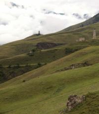
The road ahead is quite long. To Istok - 15 km. There was a feeling of hunger. I didn't find any berries. I collected raspberry leaves along the road and chewed along the way. In front of the village, Voronovo noticed a farmstead - a small farm where, judging by the announcement posted by the road, you can buy dairy products and meat. Went up to the gate. A middle-aged woman walked towards me. I spoke with the owner. They also have an apiary. But since the whole of June was rainy (only 2 sunny days), it was not possible to collect honey. I bought cream and continued on my way. The estate turned out to be the richest in the entire region. Most of the log cabins were very dilapidated, rickety, unsightly. Same fence. It should be added that the plots are very small. Above the village of Voronovo, a stream crossed the road - the future Volga. Here its width is only 2 m. But you already feel that this is not one of those streams that I met along the way. This is already something very significant, majestic. It is very difficult to go along the channel - there is practically no coast. Or densely overgrown forest or swamps. Slightly higher to the left is an ecological trail. I followed her. She must lead me straight to the Source. After 200 m from the road, the trail crossed over to wooden footbridges, very dilapidated, in some places failed. Under the footbridge is a swamp. Gradually I go up. Dense forest and clouds of mosquitoes. But my gaze rests on beautiful white mushrooms. I'm getting the whole package. But they all turned out to be bastards. It turned out later. The forest is amazingly beautiful, mixed - pines, birches. High herbage. I often go off the trail. So you think that a clearing will appear from behind a tree, on which Shishkin's three bears frolic. Sometimes you yourself want to become an artist and transfer to the canvas everything that opens before your eyes and overwhelms your perception. Soon the Spaso-Preobrazhensky Cathedral and the St. Nicholas Church of the Olginsky Women's Monastery opened on the hill. The cathedral is in a state of overhaul. I look at it and there is a great desire to take part in its restoration.
The first one is the men's Volgoverkhovsky Monastery of the Transfiguration of the Savior, founded in 1649 by decree of Tsar Alexei Mikhailovich. It quickly fell into disrepair, and in 1724 the monastery buildings burned down. The monks were assigned to the Nile Hermitage. Only the chapel above the source remained, which was destroyed from time to time, but it was restored. Residents of the village of Volgino Verkhovye, settled in 1740, took care of keeping the Istok itself and the Chapel with it clean. The pilgrimage to the source never stopped. At the end of the XIX century. A new nunnery was built, called Holgina. Abbess Vera became the abbess. The nuns were engaged in housekeeping and construction. They did educational work. The monastery had a library, in 1914 a parochial school was opened. In 1918, the Holguin Monastery was officially abolished. But the monks served in the temple and worked in the Volgoverkhov artel they created until 1924. In 1999, the Olginsky Convent was reopened. Every year at the end of May, a water blessing of the Volga Source is held.
I'm going down to the first bridge across the Volga. Marvelous. About 150 m from the Source, and the river rages like a mountain. Cloudy weather but no rain. Therefore, there are many visitors today. They mostly drive good imported cars. They also take tourists from Seliger bases and sanatoriums. Many of the visitors, having heard about the healing power of water, take baths. Having walked along the ecological path, due to the high grass stand and yesterday's rains, I found myself all wet. But this did not prevent me from taking advantage of the great opportunity to climb into the spring water and feel its coolness and miraculous effects.
The sun peeked out from behind the clouds. It was already high and I realized that it was time to return. Passed through the village of Volgoverkhovye. Great place to spend your life here. But it is located on the territory of the reserve - it is impossible to settle here and the land is not for sale. Only two families, maintaining their former way of life, manage their households and give dynamics to this whole fabulous picture. Went back quickly. I was constantly pursued by gadflies and horseflies, so sometimes I had to go on a run. The camp was already waiting for me.
An important event was planned for this day - the launch of the boat into the water. We spent the first descent in Astrakhan, but complete calm did not allow us to test the running and tacking qualities of our vessel. Moreover, in Astrakhan we swam with Max together, but here we had to cover more than a thousand kilometers together, and even with a load - more than 400 kg in total. Installation load capacity - 260 kg. So it's obviously an overload. RVS decides to sacrifice himself. If the boat does not pull, he is ready to return home - they say, the most important thing has happened - he visited the Source.
The second task of the day is to find the place where the Volga brook flows into the lake. Rod. During the first tests of the boat in Astrakhan, the mast bent, so before entering the water, it was necessary to strengthen it. We decided to insert a wooden rod inside. I managed to find a freshly cut aspen with a straight trunk. They hammered it on a tight one, the mast turned out to be quite strong. In case it breaks, I brought a spare two-piece with me. On the boat, it was adapted to a kind of bowsprit. We carry the boat to the shore. Set up the mast and sails. We sit down, row from the shore. And about a miracle! We are sailing. There is a lack of skill. But gradually we are adapting and we are going quite confidently. We go both sharp and full courses, until we are convinced of the excellent tacking qualities of the vessel and that it is quite possible to walk on it with three of us. The question remains whether the dinghy will also pull the load. But we will solve it tomorrow. And now we are heading to the village of Kokovkino - to the place where the Volga flows into Lake Sterzh. We roam the grass for a long time. We reach the village. We ask - where is the same place? They explain to us that it is overgrown with grass and forest and you cannot take it with your hands. Nevertheless, we pass along the entire coast. Only the approach of a storm front forces us to return. We manage to reach the village of Novinka and bring the boat ashore. Covers the rain. RVS and I are going to the museum of local lore. The museum is located on the first floor of a two-story log house. Various finds from the Upper Volga Reservoir located on the Upper Volga Reservoir are collected and stacked here. villages. You can touch them, turn them in your hands. The exhibits are simply laid out, there is no clear systematization. On the second floor there is a children's camp. This year a group of Moscow guys are resting here. They are led by school teachers.
Remarkable history of the village of Novinka. At the confluence of the Volga in the lake. Sterzh is located Sterzhenskoye settlement - the site of the ancient tribe of the Dyakovo culture. The settlement dates back to the second half of the first millennium BC. and is considered the oldest settlement in this region. The settlement probably served as a transit point on the way from the Volga to Seliger and to the upper reaches of the Western Dvina. There was also a stone Sterzhensky cross, erected by the Novgorod posadnik Ivank Pavlovich in 1133. At the end of the 10th century. the inhabitants of the settlement, apparently, moved to a new place - "Sterzhensky churchyard", where the wooden church of Peter and Paul was located. In 1807, the construction of a stone church began on this site. "Sterzhensky churchyard" grew up in the village of Novinka.
It was already evening when Max and I went for mushrooms. They collected boletus, boletus, porcini mushrooms. I saw them for the first time. But my comrades convinced me that these are quite normal, edible mushrooms. Some of them we did immediately weed out. The selected ones were cleaned and fried. I must admit that I like Astrakhan mushrooms more both in taste and smell. But I tasted the strawberries that grew on our hill with great pleasure. It's raining. We go to sleep. Tomorrow is the first day of our journey.
July 9, Wednesday
Thesis: We are sailing
Adventure: Going under load
Route: v. Novinka - v. Gorodok - v. Vysokoye - v. Runo - 15 km
Description:
Today is the first day in two respects: the first sunny day and the first day of our sailing. Woke up early enough. It's hard to say exactly what time - we don't have a clock or a compass. This is such an amazing coincidence. Max has no watch at all, I lost mine before leaving, RVS - I forgot it at home. It was necessary to navigate in time by the sun. The Valdai Upland is located quite high in latitude and at this time of the year there are white nights. Therefore, it gets dark late, the stars are not visible, it dawns early. Even the time of day is not so easy to determine.
Hercules was cooked for breakfast, because we didn’t have anything else from the products. We practically did not take food with us, because we expected to purchase and replenish them in numerous villages during our Expedition. However, it turned out that there was no shop in the village of Novinka. Firewood dampened during the month of rains. Not so much burning as smoking and drying. While cooking porridge, they ate lard and drank coffee. Original combination. When breakfast was ready, Max's head appeared from the tent.
It rained at night. In the morning, the sky began to slowly clear up. The emerging wind finally dispersed the clouds and, finally, the sun shone in full. After breakfast, preparations began. Things in the pile kept adding and adding. We were more and more horrified, standing up for further prospects for their transportation. We have already developed a discussion about what things it will not be a pity to leave. Determine the essentials. They began to demolish everything to the bathhouse, which was to be launched - it took several walkers. While the RVS and I were packing things, installing all the weapons on the boat, Max dug up worms from Alexander in the yard. We seriously counted on fresh fish. In an incomprehensible way, slowly, all our things were pushed around the boat: food, repair kit, sleeping bags - into the cockpit. Dried vobla - under the stern jar. Backpacks on the bottom. (They interfered with us a lot and we shifted them from place to place until they were crushed under the middle can). While packing things, I noticed four black fluffy animals at the water's edge. In my head flashed - stoats. Grabbed the camera. While I was pulling it out, the animals saw me and rushed in different directions - three back, one forward. I ran after three. They were faster and disappeared into the grass. He returned, put the camera back down and continued laying down. Suddenly I see that the animal that broke away ran right in front of me and went into the nettles. Then, making sure that no one was following him, he appeared again and began to court me from different sides. And then he completely ran up and hid under the boat. He did not pose for me, but I did take a couple of photographs.
Alexander's family and vacationers came to see us off. Everyone was very interested in the shipping qualities of our creation. We said goodbye to the hospitable inhabitants of the village of Novinka, went down to the water and set sail. After making a farewell 360-degree Fordwind turn, we hit the road. The wind was headwind, we were tacking. Moved forward quite confidently. We went to the village of Gorodok. RVS tried to find his belongings, which he forgot on the ride, which dropped them off at Novinka. But unsuccessfully. From the village of Gorodok we went very cheerfully, your pride took. That's what a good boat we built. The mood is wonderful, a feeling of self-satisfaction is bursting inside. Alright let's go! We met a kayak with amateur sails. The clew angle of the staysail was deflected into the wind with the help of an oar. Come closer. We admired this original invention and continued on our way. The wind gradually subsided. Sit on the oars. Rowing in turn. The average speed was higher than on the tack. Although our boat is not rowing, it goes well under oars. Ahead, on a hillock, through the crowns of trees, they made out the dome of the church. We went to her. As we approached, the church completely disappeared from view. We approached the poplar forest. Finding a church was no easy task. Several times they approached the shore and sailed away. Finally found. The church turned out to be a cemetery, heavily destroyed during the Second World War. Later we learned that the ruins belonged to the Church of the Holy Trinity Uvitsa Pogost, built by Toropetsk craftsmen in 1779. Everything was carefully examined, despite the pressure from mosquitoes. We moved on. Shirkov Pogost is ahead. We approach the river Runo. It's evening. The decision is already ripening in us to find a place to spend the night. They chose a magnificent place - a hill covered with herbs. On the shore is a birch. Quiet evening. Water surface. The view is just fabulous. Intoxicating scents of herbs.
As soon as they landed, Max rushed to catch the coveted pike. RVS started preparing dinner: salad and pea porridge. I took up the organization of the bivouac. Max came up only on the third call. The pike did not even look at him, but he still tore off the lure. They drank tea with clover, ate gooseberry broth in sugar syrup. Taking a walk after dinner, I found an interesting stone with a triangular notch on the top of the hill. He suggested the artificial origin of the recess. We examined the stone and recognized its ritual significance for the population that once stood here. In this part of the reservoir there are quite a lot of settlements - ancient human settlements. In general, the names of many villages speak of their ancient origin: Shirkov Pogost, Torg, Settlement, Selishche, Gora, Zalesye, Zabolotye.
By nightfall, the sky darkened. There was a lot of dew. The path for the day was not long, but it was the very first and very informative transition. Therefore, no one suffered from insomnia.
July 10, Thursday
Thesis:"It's hard for a man without women"
Adventure: Three meters from the elements
Route: Runo village - lake. Vselug - about. Zosima and Savvatia - 12 km
Description:
This morning we certainly decided to catch a fish. The RVS woke us up at approximately 6 o'clock. Max, crawling out of the tent, immediately went in search of the already legendary pike. I tried to catch a worm. After making sure that the bream itself does not feel the need for my bait, I started preparing breakfast: buckwheat with yarrow and tea with strawberries and clover. A thick fog was creeping onto the river from the bank, the firewood was damp, but the fire willingly flared up. Breakfast was quickly prepared. Max returned without a catch. We can not find an explanation for such "luck". The entire local population unanimously convinces us that there are a lot of fish and that all of them are IN! The RVS claims that either we do not know how to fish, or there are simply no fish. And, most likely the second. We have a quick breakfast and get ready. We rowed to Shirkovo. It was quite difficult to find a passage between the lakes Sterzh and Vselug. The channel turned out to be narrow and overgrown with chakan. Places probably fish. Max could not miss the opportunity to swing several times with a spinning rod. RVS and I crouched down in fear every time - so Max confidently performed all his juggling movements. But the cheese, as the poet said, is still there and the pike's tooth is numb. Having rounded a wide cape, we go out to the lake. Vselug.
"The length of the route along Lake Sterzh is 15 km. The width of the lake varies from 0.8 km to 1.6 km, the average depth is 5 m, the maximum is 8 m, at the southern end the lake becomes shallower to 2 m. The banks are raised by 2 - 3 m above the floodplain and are folded sands and boulder loams, pebbly, there are large boulders.Lake Vselug is elongated from the northwest to the southeast and south, has a curved shape, convex to the east.Length 16 km, width about 3 km, average depth 10-12 m. The bottom is mostly sandy, in some places rocky - covered with boulders.Narrow at its northern end, the lake widens behind the village of Advoritsa on the western shore and then behind the village of Orlinka on the eastern (right) shore.In its widest point, in the middle of the lake, stands Novosolovets Island" - I read in my notes, but I must stop. An incredible adventure lies ahead of us. Directly in front of the village of Shirokovo, power lines hang low. Let's get close to them. We see that we cannot pass with a 5-meter mast. We begin to quickly row back. We go to the shore and along the very coastal edge we easily overcome the obstacle. The main thing is to notice it in time and not to run into it. In Shirkovo we examine the wooden chopped church of John the Baptist built in 1697. Currently being restored by a labor camp. The temple is simple in architecture, three-tiered quadrangle, but very beautiful. The second church is more modern, red brick with a lot of architectural finesse.
We are trying to find the store and post office indicated on the map. We ask the local people. It turns out that there are two houses in the whole village. There is no shop or post office. But on certain days a mobile shop arrives, then you can overstock. In almost all villages of the Upper Volga Reservoir. a similar situation with stores. Therefore, it is better to have a stock of products. We talked with the owner of one of the houses, by the way - the former post office. The land here is sandy, sandy loam. Little is growing. There are also few meadows. They don't keep cattle. They live mostly on a pension.
We did not wait for the truck shop, although we had all the products already out. We moved on with the oars. Ahead - Malosolovetsky island or the island of Zosima and Savvatia. It is also called God's place. Here once stood a large brick church - a copy of the main cathedral of the Great Solovetsky Monastery. It arose on the site of the sketes of St. Jonah, who was here in seclusion. In 1974 the temple was blown up. Recently, a wooden chopped church was built in its place in the name of the Holy Life-Giving Trinity. I liked her very much. I didn't go inside. A bell has been preserved from the old temple. Bricks are scattered in a radius of 400 meters. We met with the minister of the church. Chatted with him. He arrived recently. Yesterday I caught a lot of large roach from the shore. So the fish are still there. On the island, I picked up a tick somewhere. Sunflower oil managed to quickly bring it out. Leaving the island, we headed to Vseluki. Having moved away from the island less than half a kilometer, we found that a thunderstorm front was rapidly approaching us and that showers were already visible near. We return to the cape of the island. We are covered in rain. The rain quickly turns into a violent thunderstorm. Thunder. A storm is rising. The boat is filled to the sides with water. We drain the water, pull the boat ashore, turn it over. We hide under a canopy of film. The thunderstorm raged for about 3 hours. Then the rain stopped. Birds chirped. And suddenly a new squall with a downpour came up. Before dark, the situation remained virtually unchanged. Then the rain stopped. We managed to build a fire from wet firewood and start drying something. Then it began to rain again and we tried to keep at least some things dry. By evening the storm was gone. Only a strong gale remained. The fire was very weak. He hissed more and exploded from drops of water flowing from firewood. There was so much smoke that we felt suffocated. Dinner was cooked on gas. The food helped keep me warm. There was an idea to take advantage of the strong steady wind and sail further. But the wind blew against us and we decided that the drift would not allow us to move forward significantly. Moreover, the RVS and Max were sure that it was very dangerous to sail in such a wind. The thought of overkill terrified them. I wanted to test the boat and rush on it with good speed. After all, what Russian does not like fast driving! However, we postponed our sailing until tomorrow and went to bed after dinner. Despite the wet sleeping bags, we all slept well.
The island of Zosima and Savvatia actually consists of two islands. They are separated by a ravine, through which a river once flowed. The capes of both islands are very convenient for parking. There are fish and mushrooms right by the shore. The right bank of the island is swampy in places, the left one is high and dry. Mixed forests with a predominance of deciduous species.
July 11, Friday
Thesis: Wires. Tablets. Mushrooms
Adventure: Mast traps.
Route: about. Zosima and Savvatia - the village of Vseluki - the city of Peno - the village of Studenets - 26 km
Description: Got up early. Max got out last. The sky is rather cloudy. RVS suggested to do without breakfast. We did not support. They made a fire, cooked rice porridge with sprats in tomato sauce. It's time to write your own cookbook of original dishes. In fact, everything was very tasty, we ate everything without a trace. Didn't get dry. Gathered and buried. The wind is opposite. Set sails, set tacks. Half an hour later the wind died down, we again switched to the oars. We have already established the order in rowing: RVS-Max-I. RVS rows with average force for quite a long time. Max rows for a short time, somewhat lazily. I row for a short time, but with a large amplitude. We are moving well, but much slower than my expectations. They came to the Universe. The village is of little interest. The only attraction is the Church with the Bell Tower. The dam, which is marked on the map, turns out to be long gone, part of the embankment has been preserved. In front of the embankment, wires weigh low, they bypassed them along the coast. There was no shop here either. Lots of fishermen. They mainly catch perch. After Vseluk we enter Lake Peno. The shores become more picturesque. There are pine forests. There was a headwind. At first they rowed. When they got closer to the town, they spread the sails. Nicely entered Peno.
The highway ran through the town. Pretty busy road. The houses are all wooden, there are more modern styles of buildings. Max with RVS went to the market. Spent 300 rubles. Later, this amount will become a certain standard. Loaded up and sailed. But where to swim is not clear. Where is the exit to the lake? Volgo? Turned to one, the other. Everything is shown in different directions and everything is wrong. We look at the map and confidently move under the bridge. The whole river here is blocked by numerous nets: short - 2-3 m. But there are a lot of them. Youth shines. There are two bridges ahead - road and rail. Most likely you will have to remove the mast. We approach the road bridge. In front of the bridge we see the wires of the power line. Quietly approach them under sail. STOP! BACK! ROW! Directly in front of us, half a meter of wire, which we had not noticed before. We are carried straight to them. We frantically pull the oars. Another moment and fireworks we can not avoid. They hang very low - only 3 m. We row with all our might, drop the sails, go under the shore. We are trying to guide the boat under the wires along the shore, tilting it by the mast - it does not work. We go under the left bank. Can be done. We pass the second line of power lines. I'm going under the bridge. In the central part of the bridge, the metal structures are broken. It seems that the mast will pass there. We row. Above the flagpole to the bridge structures remains 5 cm. Carefully row. STOP! Wires again. Again to the shore. Quietly, quietly we dive. Passed. There are 2 more power lines ahead, but they are already hanging higher and you can see them. There are no warning signs anywhere. This stage can be called - the last hero. This is for those who made it through. Advice for sailing enthusiasts - do not sail near Peno with the mast up.
 Finally we leave for the Volga. The lake is like a pond. Everything is overgrown with grass. Places are probably fish. In any case, networks are everywhere. Further, the surface of the water is somewhat cleared. The water is still red-brown. We see a convenient parking place on the port side. We stop to boil tea. We rush into the forest. We collect mushrooms. We turn to the fishermen for help. Most of them appear to be poisonous. The tea boiled. We drink, take pictures, row further. Soon the sun begins to set. We have quite a lot of wet things. It wouldn't hurt to dry out. We find a beautiful, convenient place for parking on the cape behind the village of Studenets. Charming mixed forest attracts our eyes. We're heading there. There is a tent on the beach. RVS and Max insist on a bivouac here. We get up. Arranging a whole gallery of wet things. The setting sun has time to warm some. A lot of mosquitoes. We dry things on ourselves in front of a fire. Max is still trying to catch the fish but fails. We cook cabbage soup and fry mushrooms. We overeat. Mushrooms are somewhat bitter, but seem to be edible. True, at night after eating them, I had sticky sweat. There were no other signs of poisoning. From mosquitoes we burn pills in the tent.
July 12, Saturday
Thesis: Lokhovsky triangle - an anomaly of time. There, the stupa with Baba Yaga goes, wanders by itself. Taiga forests of Valdai.
Adventure: We are afraid of the elements. Inhabited island. We are being followed by a car. Like butterflies, we fly to a beyshlot, not thinking about anything. With a beyshlot on you.
Route: Gorodishe village - Mal. Lokhovo village - Volga village - Bely Plav island - Selishche - Beishlot - 36 km
Description:
We don't get up early. The weather is cloudy, there is no wind - so you have to go by oars. The prospect is not the most pleasant for my companions. We assigned the main calculation to the sails. The oars were planned to be used only as an auxiliary propulsion device. Today, on the fourth day of sailing, we are forced to admit that sailing on ships of this class requires serious rowing skills from the team. For me personally, the need to use oars to move the boat is a great chance to build muscle and I perceive rowing as a sports workout. I try to row with the greatest amplitude and until fatigue becomes general. However, inexperience affects the uneven stroke. RVS already has the practice of water trips and skill in rowing. Therefore, he turned out to be the most enduring of us, rowing the longest. Max has a physique that can be envied. For a powerful stroke, he does not need to put a lot of effort. But "mother laziness," as he calls her, does not always make it possible to express himself at 100%. The three of us make up a good trio: one rows and creaks with oarlocks. The second steers and gives commands: row, taban, sushi paddles. The third is sleeping and only sniffling is heard. This is how we walk.
For breakfast we cook oatmeal. We drink coffee. We are going slowly. We talk about different topics. The main place in our conversations is occupied by history and cooking. This is all the specifics of the RVS and he enlightens us with pleasure. This usually happens either on the move in the boat, or is used as a bedtime story. It cannot be said that Max and I were always silent. Max is always actively discussing everything. And this sometimes interferes with him when rowing. Scholars arguing on a ship is a common occurrence. I conduct a daily familiarization of the crew with local attractions and read a lecture on this topic. But talk is talk, and it's time to pack up and swim. The first days of the voyage were not exemplary in terms of length. Apparently we need to get on the route earlier and spend more time on the road. I'm going to row. The places around are pretty - mostly pine forests.
We reach the village of Bol. Lokhovo. Sitting there on the shore is one sucker with a fishing rod. We swim up to him and ask - what time is it 9 o'clock or an hour. And he answered us: "Yes, somewhere like that." We thank you and move on as if nothing had happened.
The village of Mal.Lokhovo is a fishing base. Fishing here is possible only by permits. We were very interested in the ferry crossing. The ferry looks like an ordinary chopped raft. It is pulled with special levers in the form of the English letter F. No less interesting are the tall stairways, which rise from the water up to 30 meters along the high bank.
The tourist map shows a small channel from Lake Lokhovo to Lake Volgo2. We have been making our way through it for 1.5 -2 hours and we can’t get through. The actual distance is much greater than on the map. The shores are close to each other. Lots of fishermen. We are also tempted and let the lure follow the boat. RVS makes fun of Max's fishing qualities. He vows not to fish again. We leave for Volgo2. On the starboard side are high picturesque banks. Ahead is the Volga village. There are quite a lot of new houses here - summer residences of Muscovites. The beach is pretty clean. I utter the now catchphrase "I remain." A fair wind appears, which gradually freshens and becomes quite strong. We set the sails like a butterfly and fly. We are finally flying. I experience excitement. There are quite a lot of modernly equipped bases along the banks. The lake is cut by scooters and jet skis. Someone is trying to master windsurfing. The lake is noticeably wider than the previous ones. There is an immediate sense of space. We take out a package with dried roach from under the back can. She doesn't let us get bored. Let's have a little snack. In a couple of hours we reach about. White Plav. We decide to take a breath and boil tea. There are vacationers on the island. Meet an elderly couple. The man turns out to be a teacher at a Moscow university. He has been coming here every summer for 20 years and bringing students with him. I got into various troubles and even once turned over on a boat in a storm. We talk about ourselves, about the expedition. The hospitable islanders are surprised at how we decided to sail so far on a homemade boat without the experience of sailing, and even go in the middle of the lake in such a wind. They treat us to tea. We are warned not to buy milk in the local villages. It's kind of infected.
The island is very beautiful. It is covered with birch. The island stretches across the lake and releases long braids towards its shores so that, as a result of the high water level from the rains, the tops of the trees stick out of the water 150 meters from the coastline. It was quite amusing to sail on a boat between the birches. After the conversation, we had some concerns about the riskiness of further sailing in such a wind. But we are resolute, almost desperate comrades. Moreover, we need to catch up with the schedule. We decide to move on without delay. So, saying goodbye to new friends, we raised the sails and are heading for the village of Selishche. For the sake of safety, we decide to approach the left bank, so that in which case we have a chance to swim out. We carefully consider the procedure for overkill.
The shore of the lake is quite well inhabited, the proximity of the main road is felt. Quite a lot of amateur vacationers. Lots of private areas. They occupy the most picturesque shores. Basically, they are quite well inscribed in the surrounding landscape: the house is made of round timber, very beautifully built, on the facade there is always an open balcony. The houses are low. There are no extra buildings. Very clean and quiet (unlike campsites). The territory is fenced. We admire and come to a common conclusion: "It's good to have a house in the countryside." It is also good because the land has a master. And we must hope that he will not destroy the forest on his territory, will not violate the beauty of the surrounding nature. After all, this is his home now. We liked the recreation center spread out on the shore. Very interesting architecture. We even got closer to view the traditional Chinese tea house.
But here we come to Selishche. Ahead, as it should be, is an automobile bridge and low-lying wires. We have to approach the shore and remove the mast. We pass the bridge, we decide not to put the mast - in front of the beyshlot. Now we row in twos. The mast and boom split the ship into two compartments, it is impossible to sit in the middle of the can. The banks are low and treeless. I don't want to spend the night here. Therefore, despite the fatigue, we row forward to meet the beyshlot. What it is we don't know yet. Therefore, we are wondering how we will pass it: right on the boat or we will still have to carry it around. Of course, it is better to row than to carry the ship on yourself. Moreover, we are not sure if we can carry it far. And we still have things. Beishlot has already shown up. This is a bigger building than we thought. We are afraid of a fast current and circulation. We decide to approach the shore and choose one of the options to overcome the obstacle. We land on a rocky shore. We rise to the dam, we approach the hydraulic structure and gasp. The water drop is about 5-6 meters. Behind the beishlot, the Volga turns into a real mountain river. The water roars, breaking off the dam and rushing down with a noise. The entire surface of the water is foamy - these are streams hitting stones. We realize that our journey will be more interesting, more difficult, more dangerous. We will need coordinated energetic work to cope with the flow and not run into a pitfall, which, judging by the seething water, is quite a lot here. We unload the boat and the three of us carry it without any extra effort. While the guys are carrying things, I install all the rigging, tie the mast and boom longitudinally to the hull, place the load so that it won’t be lost if we roll over. RVS loses its last strength. Rest and food are needed. We arrange a snack. At our disposal are canned food, cookies, tea poured into a thermos, a can of condensed milk and sweets. Without regret we swallow calories, they will be useful to us now. A lot of fishermen gathered in a small gorge. They mainly catch perch, quite small. But apparently for these places it is also a fish. Food restores our strength. It's getting late, so you need to move briskly. We are finishing the final preparations. We jump into the boat at the same time and, caught up by the current, quickly rush down. RVS on the steering wheel, trying to go along the rapids, so there should be fewer stones. We row with all our might to have our own acceleration. The shores are still low, alder, overhanging. The picture is changing rapidly. The shore grows in height, reddish, bare cliffs are already visible ahead. From above the hills are covered with a dense pine forest. The places are fabulously picturesque and unreal. The river cuts a narrow gap through the mountains of Valdai. Bends, stretches, banks falling from a height of 50-70 meters. It is more reminiscent of the taiga rivers of Altai. But the Volga is a flat river. Could we, the inhabitants of the steppes, expect to see such a thing here.
It's getting dark. Ahead the river makes a turn, a very high, picturesque bank. We decide to try to get to him. To do this, you need to accelerate, cross the rapids, turn around in the opposite direction and row ashore. To do this without experience is quite difficult. Someone needs to take command of the parade. This role must be performed by the helmsman. RVS looks out for a convenient shore for landing. I take all the initiative. Everything will be decided in a matter of seconds. If we don’t have time to rake it out, it will demolish it, we will have to wait for a new place convenient for parking. We lay out and, luck accompanies us. It's hard to find a better place to bivouac. There is a real forest all around. Somewhere below, a river roars. And not many mosquitoes. But we find mushrooms. Max tries to lure the fish with worms. But she still turns up her nose. Cooking dinner - cabbage soup from nettles. We eat a lot of sweets. But fatigue makes itself felt. We postpone the walk through the forest until tomorrow.
July 13, Sunday
Thesis: " Church of Peter I"
Route: Bolshoy Volga village - Selizharovo town - Bolshoy Kosha village - Eltsy - 42 km
Description:
We didn't get up early. Cloudy morning. The RVS has already built a fire and is preparing morning coffee. Drinking coffee with sugar in the morning has already become a habit with us, which I never had at home. For breakfast - traditional Hercules. Before breakfast we take a walk in the forest. The forest is amazing. Tall pines. The soft moss lining springs underfoot and irrigates the sneakers with morning moisture. In such dampness, it is simply heavenly conditions for mushrooms. There are not many of them here. Basically - russula. Almost all the land is covered with blueberry bushes. There are no berries yet. The forest is cut with ditches - apparently this is how the forestry fights fires. Quite a lot of trenches from the Second World War remained. There are tall anthills. The walk inspired us to talk. We raise various issues to the surface. After a long debate, we conclude that life is beautiful and we must swim on. The anticipation of sailing is especially pleasant - after the stagnant lakes, now we will go with a fast current twice as fast. I expect to get to Rzhev. Before him, according to my calculations - 70 km.
In the morning gatherings, we established the distribution of responsibilities. I wash the boat, install all the rigging. Max and RVS carry things, I lay them out in the boat. Then we unload ourselves and have a good trip! The nearest point is Selizharovo. We overcome the distance of 15 km in 40 minutes. We meet quite a lot of fishermen along the banks. In Selizharovo itself, there are many women on the shore. Everything is washed, carpets are washed. We ask how much time. They answer us at 12.30 - so they might as well not ask. Throughout our journey, everyone answers us the same thing - 12.30. We moor near the bridge. We go with RVS to grocery stores. The town is small. The grocery market is closed on Sundays. The cloakroom works only on Fridays. The post office also has a day off on Saturday and Sunday. But there is a tourist shop. I would like to draw your attention to the fact that bicycles are very popular in the Tver region. Even grandmothers use this vehicle.
We move on. In the suburb of Selizharovo, we ask a local resident for the name of the church, which can be seen on the high bank. She answers us "How do I know. It seems to be the Church of Peter I." Imagine. After all, you can lay a whole excursion route here. A large number of power lines hang over the river. We pass villages. Further to the very village of Khvorostovo there are completely wild places. Beautiful nature: high banks, pine forests, birch groves, fast flowing rivers, multi-colored lawns that fill the air with intoxicating aromas of herbs, many streams. There are convenient parking lots along the banks. Lots of vacationers. We imperceptibly pass the village of Bol. Cat. Next - the village of Rog. Pella boats are scattered in large numbers along the banks of the villages. Almost all of them with broken cans and fenders. In some areas, the flow of the river slows down. But mostly very fast. We use this as an excuse to cheat - spend time talking and rowing less. But in vain. It always seems to us that Rzhev is already around that turn. Several times we had already decided that we had sailed. And he is not and is not. But we have already passed 40 km from Selizharovo. We look at the map - and before it is another 77 km. It's already around 8 pm. It starts to rain. We decide to stop at the bivouac. We find a suitable place and find ourselves in a fabulously beautiful light pine forest. Throughout our route, amazingly beautiful places. The eye does not get tired of admiring them. You feel how everything inside comes to life and is reborn from the contemplation of the surrounding nature.
July 14, Monday
Thesis: Here's a new twist
Adventure: Overcoming the ferry cable
Route: Bolshoy Kosha village - Eltsy village - Sytkovo village - Gorki village - 45 km
Description:
The day was quite sunny. The current became noticeably weaker, but by the bend of the village of Sytkovo it again returned to its previous speeds, and it was there that we had to experience another adventure. D. Sytkovo was located on a high bank. We really hoped to get milk and cream in the village, exchanging them for dried vobla, of which we still had quite a lot. Another 2-3 km before the village, we spotted a rather high church on a hill. Women were fishing on the shore. We swam up to them, made sure that it was Sytkovo and moored to the sandy shore. RVS volunteered to stay in the boat. We happily climbed ashore and headed up to the village. The village consisted of 5 houses. The inhabitants did not have milk, but they showed us a house in a nearby village, where the hostess kept cows and was engaged in the sale of dairy products. We began to make our way to the church. Close to it came the courtyards of the inhabitants. We had to go through them. In one of the courtyards, right at the entrance to the church, a goby was grazing. He refused to accept us as his own, apparently decided that we were encroaching on his shrine. He issued a war cry, lowered his head and headed towards us. But the rope with which he was tied did not allow him to realize his plans. The church was badly damaged during the war. The brick dome, only a third of which was preserved, miraculously held on. But the icon of St. Nicholas hung over the gates, which is why we decided that the inhabitants of the nearest villages still come here on holidays. Mission accomplished. We went back not along the path, but straight down the hill and were gifted with strawberries. After eating, typing RVS, we went down and set sail. Max and I sat on the oars. RVS taxied and enjoyed red small, but very fragrant berries. RVS headed for the house where we were going to buy milk. Suddenly there are wires right in front of us. Stop! Let's kick back! 2 meter! But no, the current is too strong. It's a rope! Row! Taban! Let's turn! Half a meter! We were turned across the river. This place has a crazy current. We run into the cable with all our might, it caught on the fender. We start to roll over. All at once we grab the cable, lift it and throw it over ourselves. Let's move on. A few seconds of mass coma. Phew! We're lucky. If they had run in with their noses, they would have turned over for sure. We row to the shore. Max managed to find the owner and exchange the fish for milk. They eat it with bliss with RVS. Their strength was restored and we continued on our way.
July 15, Tuesday
Thesis: What a beauty
Adventure: The cap is back
Route: D. Gorki - Rzhev - 45 km
Description:
We spent the night in a rather interesting place. The river had just passed the village of Novoalekseevskoye, turned west, and suddenly a new bend. A river flows into the Volga from the west, and almost in the middle of the Volga - an island with a shallow. And it turned out to be a quiet backwater, practically without a current. The coast is not as high as before, covered with pine forest. Last night we were all very tired, so we were not able to perceive all the charm around us. But this morning we decided not to miss the opportunity and walk through the forest. Narrow paths took me deep into the forest. The trees filled the hill quite densely. At the top we found dugouts. And all the slopes were overgrown with blueberries with a continuous carpet. I even collected it and treated my comrades. By the way, traditional medicine uses blueberries to improve vision.
Nothing extraordinary happened during the day. The most vivid impression was left by the automobile bridge across the Volga in front of Rzhev. The load-bearing metal structures raised it quite high, so we noticed it from afar. The width of the river was about 200 meters. The forest was close to the banks. The bridge looked very contrasting against the backdrop of a fast river and green banks, and it even seemed to me that it harmoniously fit into the landscape. It was the first major bridge on our way, it gave us a wonderful chance to climb up and take a panoramic photograph of the area and the river. We took advantage of this opportunity and at the same time stretched our legs, which were gradually losing their walking skills. (After all, our work is sedentary and any step to the side is regarded as an attempt to escape from the ship or even to overkill). The view from the bridge was charming. Our boat looked like a toy from above and had a rather attractive appearance. We climbed down and started on our way. As soon as we sailed away, a gust of wind came up and Max's cap was in the water. Our speed was much greater than that of a wet cap, the distance between us increased. But Max did not want to lose his cap. We turned around and walked towards her. The attention of my friends was completely absorbed by the waterfowl cap and they even forgot about the need to work with oars and a steering wheel. The cap floated sideways and made a dive, plunging us into a state close to both surprise and disappointment. Max's face expressed despair, but it was quickly replaced by humility. We got back on track. But then suddenly the cap again appeared on the surface of the river about 30 meters from us. The chance was not to be missed. This time we managed to show all our sailor skills, the cap was taken on board. Max was happy. Satisfied, we moved on. Our today's destination is Rzhev. It's still far enough from him. Therefore, it is necessary to maintain a fast pace of rowing. Luckily the current is pretty fast.
Finally, we reach that cherished turn, behind which we guess the city of Rzhev from the high masts of mobile communications and television broadcasting seen in the distance. Rzhev is the first major city on our way. The suburb consists of summer cottages. Such farms differ from villages in density, multiplicity, neatness of houses, and planning of plots. There are many swimmers and fishermen along the shores. It gets dark quickly. Everyone is pretty tired. Looking for a good place to park. Of course, you don't want to spend the night in the city. We are already accustomed to choosing the most beautiful, most fabulous places for a bivouac. Therefore, one of the alternatives was to stop in front of the city. But the suburbs stretched out in a wide strip along the right bank. On the left side there is a high, furious coast; there are no places convenient for parking either. We enter the city. The city is immediately recognizable by the ugly outlines of outlying houses. We pass the road bridge. On the left bank there are recreation centers, a green park. On the map, this place is called "Sosnovy Bor". They landed, but did not dare to get up in the park. On the opposite bank, I refused to get up. It is heavily littered, and the landscapes do not inspire. We paddle further. We pass a ferry crossing in the form of a stretched cable. On the right bank, behind the recreation center, we see an open place on a high bank with pine trees. No one had the strength to keep going. The controversy is getting tough. We're heading for the coast. We unload, prepare coffee, eat condensed milk. There is a third wind. Enough of it exactly enough to lift the boat up the steep path. We did not dare to leave it below. Fifty meters and we fall near the boat. Meanwhile, it is still necessary to put up a tent, cook dinner and glue the oars, which cracked at the place where the oarlocks were attached, which seriously frightened us. It will be very difficult to go along a rather narrow river without oars, and even with a constantly headwind. I glue the oars, my boat. Dinner was wonderful. RVS does not tell us historical bedtime stories, and it is not required.

The first mention of the Volga River dates back to ancient times, when it was called as "Ra". In later times, already in Arabic sources, the river was called Atel (Ethel, Itil), which means “great river” or “river of rivers”.
The current name "Volga" has several versions of its origin. The version about the Baltic roots of the name seems to be the most probable. According to the Latvian valka, which means "overgrown river", the Volga got its name. This is how the river looks in its upper reaches, where the Balts lived in antiquity.


The source of the Volga River is the place where the Volga River begins. Located in the Ostashkovsky district of the Tver region.

Being at the source, you can easily step over from one bank of the great Volga to another.

The largest European river Volga begins at the southwestern outskirts of the village of Volgoverkhovye, at an altitude of 228 meters above sea level.

Above the source of the Volga there is a chapel.

Near the source of the Volga River are the churches of the Olginsky Convent.

Also here is the first bridge. The length of this "crossing" is three meters.

The first major settlement from the source of the Volga is Rzhev. Of the settlements located between it and the beginning of the river, two villages can be noted - Peno and Selizharovo.

Peno is an urban-type settlement (since 1930), the administrative center of the Penovsky district of the Tver region of Russia.

It is located on the Volga River, its tributary the Zhukopa River and Lake Peno.
It arose in 1906 as a station settlement that grew up next to the village of the same name.

During the Great Patriotic War, Nazi troops occupied the village for several months. Partisan detachments operated in the vicinity of the village. On November 23, 1941, in the village, after torture, the Nazis shot one of the organizers of the partisan movement, Komsomol member Liza Chaikina, who in 1942 was posthumously awarded the title of Hero of the Soviet Union.

A stele at the site of her execution.

House-Museum of Lisa Chaikina,

Volga near Selizharovo.

The village of Selizharovo is the administrative center of the Selizharovsky district. It is located on the Volga at the mouth of the Selizharovka and Pesochnya rivers. Here the railroad Likhoslavl - Soblago and the highway Rzhev - Ostashkov intersect.

This settlement originated in ancient times on the trade route from Novgorod to the Caspian Sea. Presumably, it arose at the Selizharov Monastery, built in 1504. At first it was a monastic settlement, and since 1862 the settlement was called Selizharovsky Posad. Trade ships passed through it. The population was engaged in agriculture, cattle breeding, various crafts.

Resurrection Church
On the left side of the Volga, at the end of Tikhomirov Street in the village of Selizharovo, there is a church built in stone in 1763 on the site of two wooden ..

Trinity Selizharovsky Monastery

Church of Peter and Paul
Next Rzhev.

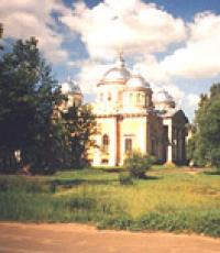
Volga and the Church of the Icon of the Mother of God Okovetskaya in Rzhev

Volga near Rzhev

Rzhev is an old city. For the first time in written sources (Novgorod Charter) it is mentioned from 1019, there is also a later date - 1216.
There is no unequivocal opinion among historians yet. Later it was part of the Toropetsk principality, from 1225 it became the center of the specific Rzhev principality. At the beginning of the XIV century, Rzhev entered the Moscow principality. Later it was included in the Novgorod, and then the Tver province.

Cathedral of the Icon of the Mother of God Okovetskaya

Church of the New Martyrs and Confessors of Russia

Park named after V.V. Gratsinsky

Monument at the grave of V.V. Gratsinsky
27-year-old military commissar V. V. Gratsinsky, commander of a detachment of 1000 bayonets, died in battle with the White Czechs on September 2, 1918, near the village of Morkvashi near Kazan. His body was taken by soldiers to Rzhev, where on September 11, 1918, he was buried with military honors in the Nikolsky Garden (now the Gratsinsky Park).

Monument to Lenin on Sovetskaya Square

Stele "Rzhev - the city of military glory"
In Rzhev, a lot reminds of the war.

Bridge and obelisk in honor of the heroes of the Great Patriotic War

Obelisk to the heroes of WWII

Bas-relief on the pedestal of the obelisk to the heroes of the Great Patriotic War

Alley of Heroes of the Soviet Union - participants of the Rzhev battle
Rzhev was seriously damaged during the Great Patriotic War. In the famous Battle of Rzhev, which lasted from January 1942 to March 1943 and included four offensive operations, the irretrievable losses of the Soviet troops amounted, according to various estimates, to more than 400,000 people.
Memorial complex to fallen soldiers-internationalists and participants in other local conflicts
Despite the fact that there are many different beautiful rivers in Russia, nevertheless, the Volga is the most valuable for it, the population of the country calls it majestic, based on the fact that the Volga is the queen of all Russian rivers. Scientists geologists determine from deposits in the earth's crust that over the immeasurably long history of the Earth, significant areas of the present Volga region have more than once turned into the seabed. One of the seas slowly receded to the south about twenty million years ago, and then the Volga River flowed in its wake. The Volga did not begin in Valdai, but near the Ural Mountains. She, as it were, cut a corner, taking the direction from there to the Zhiguli, and then carried the waters much more east than now. Movements of the earth's crust, the formation of new heights and depressions, sharp fluctuations in the level of the Caspian Sea and other reasons forced the Volga River to change direction.
Origin of the river's name
From the facts of ancient history, it is known that a well-known Greek scientist at that time named Ptolemy in his Geography called the Volga River by the name "Ra". Not looking at the fact that he lived far from the Volga, on the coast of Africa, in the city of Alexandria, but rumors about this great river also reached there. It was in the 2nd century AD. Later, in the Middle Ages, the Volga was known as Itil.
According to one version, the Volga acquired its modern name according to the ancient Mari name of the Volgydo River, or, which in translation meant “bright”. According to another version, the name of the Volga comes from the Finno-Ugric word Volkea, meaning "light" or "white". There is also a version that the name Volga comes from the name Bulga, associated with the Volga Bulgarians living on its banks. But the Bulgarians themselves (the ancestors of modern Tatars) called the reuk "Itil", a word that means "river" (there is, however, another version that the meanings of the hydronyms Volga and Itil then did not coincide with modern ones), it is believed that the origin of the ethnonym "Volga "from the Proto-Slavic word meaning volgly - vologa - moisture, thus the possible meaning of the name of the Volga is like" water "or" moisture ", if you can put it, "big water" is also suitable, due to the huge size of the river. The presence of the rivers Vlga in the Czech Republic and Vilga in Poland speaks for the Slavic version of the origin of the name.

The source of the Volga
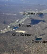
The source of the Volga is the key near the village of Volgoverkhovye in the Tver region. In the upper reaches, within the Valdai Upland, the Volga passes through small lakes - Small and Big Verkhity, then through a system of large lakes known as the Upper Volga lakes: Sterzh, Vselug, Peno and Volgo, united in the Upper Volga reservoir.
Geographic location of the river
The Volga originates on the Valdai Upland (at an altitude of 229 m), flows into the Caspian Sea. The length of the Volga is 3530 kilometers. The mouth lies 28 m below sea level. The total fall is 256 m. The Volga is the world's largest river of internal flow, that is, it does not flow into the oceans. The source of the Volga is the key near the village of Volgoverkhovye in the Tver region. In the upper reaches, within the Valdai Upland, the Volga passes through small lakes - Small and Big Verkhity, then through a system of large lakes known as the Upper Volga lakes: Sterzh, Vselug, Peno and Volgo, united in the so-called Upper Volga reservoir.


The river can be conditionally divided into three main parts, these are:
upper Volga, the largest tributaries of the upper Volga - Selizharovka, Darkness, Tvertsa, Mologa, Sheksna and Unzha. After the passage of the Volga through the system of Upper Volga lakes in 1843, a dam (Upper Volga Beyshlot) was built to regulate the flow of water and maintain navigable depths in low water. Between the cities of Tver and Rybinsk on the Volga, the Ivankovskoye reservoir (the so-called Moscow Sea) with a dam and a hydroelectric power station near the city of Dubna, the Uglich reservoir (hydroelectric power station near Uglich), and the Rybinsk reservoir (hydroelectric power station near Rybinsk) were created. In the region of Rybinsk - Yaroslavl and below Kostroma, the river flows in a narrow valley among high banks, crossing the Uglich-Danilov and Galich-Chukhloma uplands. Further, the Volga flows along the Unzha and Balakhna lowlands. Near Gorodets (above Nizhny Novgorod), the Volga, blocked by the dam of the Gorkovskaya hydroelectric power station, forms the Gorky reservoir.

The middle Volga, in the middle reaches, below the confluence of the Oka, the Volga becomes even more full-flowing. It flows along the northern edge of the Volga Upland. The right bank of the river is high, the left is low. Near Cheboksary, the Cheboksary hydroelectric power station was built, above the dam of which the Cheboksary reservoir is located. The largest tributaries of the Volga in its middle reaches are the Oka, Sura, Vetluga and Sviyaga.


The lower Volga, where in the lower reaches, after the confluence of the Kama, the Volga becomes a mighty river. It flows here along the Volga Upland. Near Tolyatti, above the Samarskaya Luka, which is formed by the Volga, skirting the Zhiguli mountains, the dam of the Zhiguli hydroelectric power station was built; above the dam extends the Kuibyshev reservoir. On the Volga, near the city of Balakovo, the dam of the Saratov hydroelectric power station was erected. The Lower Volga receives relatively small tributaries - Sok, Samara, Big Irgiz, Eruslan. At 21 km above Volgograd, the left branch - Akhtuba (length 537 km) - separates from the Volga, which flows parallel to the main channel. The vast space between the Volga and Akhtuba, crossed by numerous channels and old rivers, is called the Volga-Akhtuba floodplain; the width of floods within this floodplain reached 20-30 km before. On the Volga, between the beginning of the Akhtuba and Volgograd, the Volga hydroelectric power station was built; the Volgograd reservoir extends above the dam.
The Volga delta begins at the point of separation from its channel Akhtuba (near Volgograd) and is one of the largest in Russia. There are up to 500 branches, channels and small rivers in the delta. The main branches are Bakhtemir, Kamyzyak, Staraya Volga, Bolda, Buzan, Akhtuba (of which Bakhtemir is maintained in a navigable state, forming the Volga-Caspian Canal).

Territorial division of the river
Geographically, the Volga basin includes Astrakhan, Volgograd, Saratov, Samara, Ulyanovsk, Nizhny Novgorod, Yaroslavl, Ivanovo, Kostroma, Moscow, Smolensk, Tver, Vladimir, Kaluga, Orel, Ryazan, Vologda, Kirov, Penza, Tambov regions, Perm Territory, Udmurtia, Mari El, Mordovia, Chuvashia, Tatarstan, Bashkortostan, Kalmykia, Komi, Moscow, and some others.
The Volga is connected to the Baltic Sea by the Volga-Baltic waterway, the Vyshnevolotsk and Tikhvin systems; with the White Sea - through the Severodvinsk system and through the White Sea-Baltic Canal; with the Azov and Black Seas - through the Volga-Don Canal.


The main food of the Volga River is melted external waters. Rains, which fall mainly in summer, and groundwater, due to which the river lives in winter, play a lesser role in its nutrition. In accordance with this, in the annual level of the river, there are: high and prolonged spring floods, a fairly stable summer low water and a low winter low water. The duration of the flood is an average of 72 days. The maximum rise in water usually occurs in the first half of May, half a month after the spring ice drift. From the beginning of June to October - November, a summer low water is established. Thus, most of the navigation period, when the Volga River is ice-free (on average 200 days), coincides with the period of low low water levels (2 - 3 m).

History of the Volga River
It is believed that the first mention of the Volga is found in the writings of the ancient Greek historian Herodotus (V century BC). In the story about the campaign of the Persian king Darius against the Scythians, Herodotus reports that Darius, pursuing the Scythians across the Tanais (Don) River, stopped at the Oar River. They try to identify the Oar River with the Volga, although Herodotus also reported that the Oar flows into the Meotida (Sea of Azov). Sometimes they also see the Volga in another river, about which in the 1st century. BC e. said Diodorus Siculus.
At first, the Scythians lived in very small numbers near the Araks River and were despised for their infamy. But even in ancient times, under the control of one warlike and distinguished by strategic abilities of the king, they acquired a country in the mountains to the Caucasus, and in the lowlands along the coast of the Ocean and Meotian Lake - and other areas up to the Tanais River.
In the written ancient Roman sources of the 2nd-4th centuries, the Volga is geographically identified as the river Ra - generous, in the Arabic sources of the 9th century it is called Atelya - the river of rivers, the great river. In the earliest ancient Russian chronicle, The Tale of Bygone Years, it is said: “From that Volokovsky forest, the Volga will flow to the east and flow ... into the Khvalisskoye Sea.” Volokovsky forest - the old name of the Valdai Upland. The Caspian Sea was called Khvalisskiy.
The geographical position of the Volga and its major tributaries determined already by the 8th century its importance as a trade route between East and West. It was along the Volga route that the flow of Arab silver poured into the Scandinavian countries. Fabrics, metals were exported from the Arab Caliphate, slaves, furs, wax, and honey were exported from the Slavic lands. In the 9th-10th centuries, such centers as the Khazar Itil at the mouth, the Bulgar Bulgar on the Middle Volga, the Russian Rostov, Suzdal, and Murom in the Upper Volga region played a significant role in trade. Since the 11th century, trade has been weakening, and in the 13th century, the Mongol-Tatar invasion disrupted economic ties, except for the upper Volga basin, where Novgorod, Tver and the cities of Vladimir-Suzdal Rus played an active role. Since the 15th century, the importance of the trade route has been restored, and the role of such centers as Kazan, Nizhny Novgorod, and Astrakhan has been growing. The conquest of the Kazan and Astrakhan khanates by Ivan the Terrible in the middle of the 16th century led to the unification of the entire Volga river system in the hands of Russia, which contributed to the flourishing of the Volga trade in the 17th century. There are new large cities - Samara, Saratov, Tsaritsyn; Yaroslavl, Kostroma, and Nizhny Novgorod play an important role. Large caravans of ships (up to 500) go along the Volga. In the 18th century, the main trade routes moved to the West, and the economic development of the lower Volga was hampered by sparse settlement and nomad raids. The Volga basin in the 17th-18th centuries was the main area of action for the rebellious peasants and Cossacks during the peasant wars led by S.T. Razin and E.I. Pugachev.

In the 19th century, there was a significant development of the Volga trade route after the connection of the Mariinsky river system of the Volga and Neva basins (1808); a large river fleet appeared (in 1820 - the first steamboat), a huge army of barge haulers (up to 300 thousand people) worked on the Volga. Major shipments of grain, salt, fish, and later oil and cotton are carried out.
The development of the Civil War of 1917-22 in Russia is largely connected with the establishment in 1918 in a number of cities of the Volga region of the power of the Constituent Assembly Committee. The restoration of Bolshevik control over the Volga is considered an important turning point in the Civil War, as control over the Volga provided access to grain resources and Baku oil. An important role in the Civil War was played by the defense of Tsaritsyn, in which I. V. Stalin played an active role, which was the reason for renaming Tsaritsyn to Stalingrad.
During the years of socialist construction, in connection with the industrialization of the whole country, the importance of the Volga route increased. Since the end of the 30s of the XX century, the Volga has also been used as a source of hydropower. During the Great Patriotic War of 1941-45, the largest Battle of Stalingrad took place on the Volga, which preserved the name of the Volga in the history of the Liberated Territory. In the post-war period, the economic role of the Volga increased significantly, especially after the creation of a number of large reservoirs and hydroelectric power stations.

The natural world of the Volga
Large forest areas are located in the basin of the upper Volga, large areas in the Middle and partly in the Lower Volga region are occupied by grain and industrial crops. Developed melon growing and horticulture. There are rich deposits of oil and gas in the Volga-Ural region. Near Solikamsk there are large deposits of potash salts. In the Lower Volga region (Lake Baskunchak, Elton) - table salt.
In terms of fish diversity, the Volga is one of the richest rivers. There are 76 different fish species and 47 subspecies of fish in the Volga river basin. Fish enter the Volga from the Caspian Sea: lamprey, beluga, sturgeon, stellate sturgeon, thorn, whitefish, anadromous Volga or common herring; from semi-anadromous: carp, bream, pike perch, roach, etc. Fish constantly live in the Volga: sterlet, carp, bream, pike perch, ide, pike, burbot, catfish, perch, ruff, asp. Beluga is the most legendary fish of the Caspian basin. Its age reaches 100 years, and its mass is 1.5 tons. At the beginning of the century, beluga whales weighing over a ton lived in the Volga, the weight of caviar in females was up to 15% of the total body weight. Red fish - the glory of the Astrakhan region. Five species of sturgeon live here - Russian sturgeon, stellate sturgeon, beluga, spike and sterlet. The first four species are anadromous, while the sterlet is a freshwater fish. Farms also breed a hybrid of beluga and sterlet - bester. Herring-like fish are represented by the Caspian shad, common sprat and black-backed and Volga herring.
Of the salmon-like fish, the whitefish is found, the only representative of the pike-like fish is the pike. Carp fish of the lower reaches of the Volga include bream, carp, roach, rudd, golden and silver carp, asp, silver bream, gudgeon, grass carp, white and motley silver carp.
Perch fish in the Volga are represented by river perch, ruff, as well as pike perch and bersh. In stagnant shallow freshwater reservoirs of the lower reaches of the Volga, the only representative of the stickleback order, the southern stickleback, is found everywhere.

The influence of the Volga in creativity
In the figurative perception of the essence of the Russian people, the Volga plays an exceptional and central role, it is the root and core of the entire Russian people, a figurative ideal. She is always animated, human qualities are attributed to her, and the ideal Russian person must correspond to the image of this river. In literature and art, the Volga is not found too often, but truly cult works are associated with its image. In the culture of the 19th and early 20th centuries, the most “popular” representatives of culture are associated with the Volga: N.A. Nekrasov, Maxim Gorky, F. I. Chaliapin. Soviet art made full use of the image of the Volga created by the democratic art of pre-revolutionary Russia. The Volga is identified with the Motherland, it is a symbol of freedom, spaciousness, breadth and greatness of the spirit of Soviet people. The film "Volga-Volga" and the song "The Volga Flows" performed by Lyudmila Zykina played a central role in the construction of this image.
Volga Delta
The Volga Delta is the place where the first biosphere reserve in Russia was created in 1919. Five years ago, another federal state nature reserve appeared in the Astrakhan region - Bogdinsko-Baskunchaksky. We understand that nature reserves constantly have many problems, the solution of which cannot be postponed, therefore, financing of their activities is largely the responsibility of the regional budget. Astrakhan residents are proud that Maly Zhemchuzhny Island received the status of a federal natural monument last year. This is one of the most valuable natural reserves of the Northern Caspian. In addition, 800 thousand hectares of the delta have the status of a wetland of international importance. There are four state natural reserves of regional significance in our region.

The Volga Delta is recognized as the most ecologically safe delta in Europe. Our task, despite the fact that the territory for economic use is highly valued here, is to expand the boundaries of nature reserves. Now, for example, the idea of creating so-called biospheric polygons in the region is being worked out. We are among the first in Russia to do this. 300,000 hectares of the Northern Caspian and the Volga delta are to be reserved for them. In these spaces, mostly water, modern methods of economic activity will be tested, which will not damage the unique environment. We are for the openness of environmental information and always promptly respond to any signals about an emergency and problems.


The largest river valley in Europe, the Volga-Akhtuba floodplain and the delta of the Volga River, as well as the desert surrounding them, have always attracted the attention of botanists. The first studies mainly concerned the species composition of the flora. At different times, the region was visited by: P. S. Pallas, K. K. Klaus, E. A. Eversmann, I. K. Pachosky, A. Ya Gordyagin, and many other prominent travelers and botanists. In the late 1920s, more attention began to be paid to floodplain habitats. To one of the first researchers of the vegetation cover of the Lower Volga valley, S. I. Korzhinsky (in 1888), the floristic composition of its meadows and marshes initially seemed rather monotonous, but subsequently these ideas began to change. Mr. Ramensky (in 1931) noted a change in the composition of the herbaceous communities of the Volga-Akhtuba floodplain and delta as one moved downstream the river.
Story
Until the 30s. In the twentieth century, the Volga was practically used only as a transport route and a fishing basin. The main organic shortcomings of the Volga trade route for many centuries were the lack of water connections with the World Ocean and the gradation of the depths. The first shortcoming was once tried to be overcome by the organization of portages. But only very small ships could be dragged across the watersheds. Peter I organized work to connect the Volga with the Don and the Baltic Sea. However, due to the lack of equipment that corresponded to the scale of the work, the efforts expended to connect the Volga with the Don were not crowned with success. The fate of the work on the Upper Volga was different. In 1703, they began and in 1709 completed the construction of the Vyshnevolotsk system. Through the rivers Tvertsa, Tsna, Meta, Volkhov, Lake Ladoga and Niva, goods transported along the Volga got access to the Baltic Sea. The limited capacity of this water system made it necessary to look for other ways of developing water links between the Volga basin and the Baltic.

In 1810, the Mariinsky water system came into operation, connecting the Volga with the Baltic through the rivers Sheksna, Vyterga, Lake Onega, the river. Svir, Lake Ladoga and Neva, and in 1811 - the Tikhvin water system, which did the same through the rivers Mologa, Chagodoma, Syas and the Ladoga Canal.
In 1828, the construction of the Württemberg (North-Dvinsk) system was completed, connecting the Volga basin through the Sheken River, Toporninsky Canal, Siverskoye and Kubenskoye Lakes with the river. Sukhona, Northern Dvina and the White Sea. In the first half of the XIX century. work began to actively develop and to overcome another major drawback of the Volga transport route - the gradation of depths.
Along with shipping, fishing has been of great importance in the Volga basin since ancient times. The Volga has always been abundant in non-water, semi-anadromous and anadromous fish. Sharp fluctuations in catches in the Volga basin were also noted in those times when the impact of human economic activity was practically insignificant. Mills were built on small tributaries of the Volga even in pre-Petrine times. During the time of Peter I, the energy of water began to be used for metallurgical plants created in the Urals.
At the end of the XIX-beginning of the XX century. it became clear that the exceptionally favorable position of the Volga in the very center of the European part of Russia, the richest land, water and mineral resources, the vast fish wealth of the Volga basin, the availability of qualified workers in the industrial regions - Moscow, Ivanovo, Nizhny Novgorod, Ural - cannot be used in fully without developing a proper energy base.
Significance of the Volga River
Nowadays, the river plays a significant role in the Russian economy, since a large number of hydroelectric power stations are located on it, and the river itself is necessary for various maritime transportations, which are now being successfully carried out.
In addition, the Volga is the main artery of the country, supplying it with water resources, it is also worth adding that many reservoirs have been created on the Volga. And for the local residents of the village, which is located near the Volga River, it makes it possible to feel like tourists, swimming along the river, and simply admire the beautiful landscape, once again looking at it.
There is no such density of tourist facilities as in the Bakhchisarai region anywhere in the world! Mountains and the sea, rare landscapes and cave cities, lakes and waterfalls, secrets of nature and mysteries of history. Discoveries and the spirit of adventure... Mountain tourism here is not complicated at all, but any trail pleases with clean springs and lakes.

Adygea, Crimea. Mountains, waterfalls, herbs of alpine meadows, healing mountain air, absolute silence, snowfields in the middle of summer, the murmur of mountain streams and rivers, stunning landscapes, songs around the fires, the spirit of romance and adventure, the wind of freedom are waiting for you! And at the end of the route, the gentle waves of the Black Sea.

The first mention of the Volga River dates back to ancient times, when it was called as "Ra". In later times, already in Arabic sources, the river was called Atel (Ethel, Itil), which means “great river” or “river of rivers”. That is how the Byzantine Theophanes and subsequent chroniclers called her in the annals.
The current name "Volga" has several versions of its origin. The version about the Baltic roots of the name seems to be the most probable. According to the Latvian valka, which means "overgrown river", the Volga got its name. This is how the river looks in its upper reaches, where the Balts lived in antiquity. According to another version, the name of the river comes from the word valkea (Finno-Ugric), which means "white" or from the Old Slavic "volog" (moisture).
Hydrography
Since ancient times, the Volga has not lost its grandeur at all. Today it is the largest river in Russia and ranks 16th in the world among the longest rivers. Before the construction of the cascade of reservoirs, the length of the river was 3690 km, today this figure has decreased to 3530 km. At the same time, navigable navigation is carried out for 3500 km. In navigation, the channel plays an important role. Moscow, which acts as a link between the capital and the great Russian river.
The Volga connects with the following seas:
- with the Azov and Black Seas through the Volga-Don Canal;
- with the Baltic Sea through the Volga-Baltic waterway;
- with the White Sea along the White Sea-Baltic Canal and the Severodvinsk river system.
The waters of the Volga originate in the region of the Valdai Upland - in the spring of the village of Volga-Verkhovye, which is located in the Tver region. The height of the source above sea level is 228 meters. Further, the river carries its waters through all of Central Russia to the Caspian Sea. The height of the fall of the river is small, because. the mouth of the river is only 28 meters below sea level. Thus, throughout its entire length, the river descends 256 meters, and its slope is 0.07%. The average speed of the river flow is relatively low - from 2 to 6 km/h (less than 1 m/s).
The Volga is fed mainly by melt water, which accounts for 60% of the annual runoff. 30% of the runoff comes from groundwater (which supports the river in winter) and only 10% brings rain (mainly in summer). Throughout its length, 200 tributaries flow into the Volga. But already at the latitude of Saratov, the water basin of the river narrows, after which the Volga flows from the city of Kamyshin to the Caspian Sea without support from other tributaries.
From April to June, the Volga is characterized by a high spring flood, which lasts an average of 72 days. The maximum level of water rise in the river is observed in the first half of May, when it spills over the floodplain territory for 10 or more kilometers. And in the lower reaches - in the Volga-Akhtuba floodplain, the width of the flood in places reaches 30 km.
Summer is characterized by a stable low-water period, which lasts from mid-June to early October. Rains in October bring with them an autumn flood, after which a period of low-water winter low water begins, when the Volga is fed only by groundwater.
It should also be noted that after the construction of a whole cascade of reservoirs and regulation of the flow, fluctuations in the water level became much less significant.
The Volga freezes in its upper and middle reaches, usually at the end of November. In the lower reaches, ice rises in early December.
Ice drift on the Volga in the upper reaches, as well as in the section from Astrakhan to Kamyshin, occurs in the first half of April. In the area near Astrakhan, the river usually breaks up in mid-March.
At Astrakhan, the river remains ice-free for almost 260 days a year, while in other sections this time is about 200 days. During the open water period, the river is actively used for ship navigation.
The main part of the river catchment falls on the forest zone, located from the very source to Nizhny Novgorod. The middle part of the river passes through the forest-steppe zone, and the lower part already flows through semi-deserts.

Volga map
Different Volga: Upper, Middle and Lower
According to the classification adopted today, the Volga in its course is divided into three parts:
- The Upper Volga captures the section from the source to the confluence of the Oka (in the city of Nizhny Novgorod);
- The Middle Volga extends from the mouth of the Oka River to the confluence of the Kama;
- The Lower Volga starts from the mouth of the Kama River and reaches the Caspian Sea itself.
As for the Lower Volga, some adjustments should be made. After the construction of the Zhigulevskaya hydroelectric power station just above Samara and the construction of the Kuibyshev reservoir, today's border between the middle and lower sections of the river passes just at the level of the dam.
Upper Volga
In its upper course, the river made its way through the system of the Upper Volga lakes. Between Rybinsk and Tver, 3 reservoirs are of interest to anglers: Rybinskoye (the famous "fish"), Ivankovskoye (the so-called "Moscow Sea") and the Uglich reservoir. Even further downstream, bypassing Yaroslavl and as far as Kostroma, the riverbed passes through a narrow valley with high banks. Then, a little higher than Nizhny Novgorod, there is the dam of the Gorky hydroelectric power station, which forms the Gorky reservoir of the same name. The most significant contribution to the Upper Volga is made by such tributaries as: Unzha, Selizharovka, Mologa and Tvertsa.
Middle Volga
Beyond Nizhny Novgorod, the Middle Volga begins. Here the width of the river increases by more than 2 times - the Volga becomes full-flowing, reaching a width of 600 m to 2+ km. Near the city of Cheboksary, after the construction of the Cheboksary hydroelectric power station of the same name, an extended reservoir was formed. The area of the reservoir is 2190 square km. The largest tributaries of the Middle Volga are the rivers: Oka, Sviyaga, Vetluga and Sura.
Lower Volga
The Lower Volga begins immediately after the confluence of the Kama River. Here the river, indeed, can be called mighty in all respects. The Lower Volga carries its full-flowing streams along the Volga Upland. Near the city of Tolyatti on the Volga, the largest reservoir was built - Kuibyshevskoe, on which in 2011 there was a disaster with the notorious motor ship Bulgaria. The reservoir of the Volga hydroelectric power station named after Lenin is propped up. Even further downstream, near the city of Balakovo, the Saratov hydroelectric power station was built. The tributaries of the Lower Volga are no longer so full of water, these are the rivers: Samara, Eruslan, Sok, Big Irgiz.
Volga-Akhtuba floodplain
Below the city of Volzhsky, a left branch called Akhtuba separates from the great Russian river. After the construction of the Volga hydroelectric power station, the beginning of the Akhtuba was a 6 km canal extending from the root Volga. Today, the length of Akhtuba is 537 km, the river carries its waters to the northeast parallel to the mother channel, then approaching it, then moving away again. Together with the Volga, Akhtuba forms the famous Volga-Akhtuba floodplain - a real fishing eldorado. The floodplain territory is pierced by numerous channels, saturated with flood lakes and unusually rich in all kinds of fish. The width of the Volga-Akhtuba floodplain averages from 10 to 30 km.
Through the territory of the Astrakhan region, the Volga travels 550 km, carrying its waters along the Caspian lowland. At the 3038th kilometer of its journey, the Volga River splits into 3 branches: Bold Curve, City and Trusovsky. And in the section from 3039 to 3053 km, the city of Astrakhan is located along the branches of the City and Trusovsky.
Below Astrakhan, the river makes a turn to the southwest and splits into numerous branches that form a delta.
Volga Delta
The Volga delta first begins to form in a place where one of the branches called Buzan separates from the main channel. This place is located above Astrakhan. In general, the Volga delta has over 510 branches, small channels and eriks. The delta is located on a total area of 19 thousand square kilometers. In width, the distance between the western and eastern branches of the delta reaches 170 km. In the generally accepted classification, the Volga delta consists of three parts: upper, middle and lower. The zones of the upper and middle deltas consist of small islands separated by channels (eriks) 7 to 18 meters wide. The lower part of the Volga delta consists of very branched channel channels, which pass into the so-called. Caspian peals, famous for their lotus fields.
Due to the lowering of the level of the Caspian Sea over the past 130 years, the area of the Volga delta is also growing. During this time, it has increased more than 9 times.
Today, the Volga delta is the largest in Europe, but is famous primarily for its rich fish stocks.
Note that the flora and fauna of the delta is under protection - the Astrakhan Reserve is located here. Therefore, amateur fishing in these places is regulated and not allowed everywhere.

The economic role of the river in the life of the country
Since the 30s of the last century, electricity has been produced on the river with the help of hydroelectric power stations. Since then, 9 hydroelectric power plants with their reservoirs have been built on the Volga. At the moment, the river basin has sheltered approximately 45% of industry and half of all agriculture in Russia. More than 20% of all fish for the food industry of the Russian Federation is caught in the Volga basin.
The logging industry is developed in the Upper Volga basin, and grain crops are grown in the Middle and Lower Volga regions. Horticulture and horticulture are also developed along the middle and lower reaches of the river.
The Volga-Ural region is rich in natural gas and oil deposits. Near the city of Solikamsk there are deposits of potassium salts. The famous lake Baskunchak on the Lower Volga is famous not only for its healing mud, but also for its salt deposits.
Upstream ships carry oil products, coal, gravel materials, cement, metal, salt and food products. Downstream supplies timber, industrial raw materials, lumber and finished products.
Animal world

Tourism and fishing on the Volga
In the mid-90s of the last century, due to the economic decline in the country, water tourism on the Volga lost its popularity. The situation was normalized only at the beginning of this century. But the outdated material and technical base hinders the development of the tourism business. Motor ships that were built back in Soviet times (60-90 years of the last century) still sail along the Volga. There are quite a lot of water tourist routes along the Volga. From Moscow alone, motor ships run on more than 20 different routes.
For ten years now, at the initiative of UNESCO, on May 20, Russia has been celebrating the Day of the Volga, one of the largest rivers on the planet. Its basin occupies a third of the European part of the country, passing through the territories of 15 constituent entities of the Russian Federation.
/ The great river originates from a small underground spring that flows near the village of Volgoverkhovye in the Tver region, then passes through a system of lakes united in the Upper Volga reservoir. The first large settlement on the Volga is the city of Rzhev. It is located only 200 kilometers from its source. Behind it begins the navigable zone of the river.
1 of 23
The great river originates from a small underground spring that flows near the village of Volgoverkhovye in the Tver region, then passes through a system of lakes united in the Upper Volga reservoir. The first large settlement on the Volga is the city of Rzhev. It is located only 200 kilometers from its source. Behind it begins the navigable zone of the river.
/ The next major pier on the Volga is the city of Staritsa, founded in 1297 by Prince Mikhail Yaroslavich of Tver. The main attraction of these places is the Holy Assumption Monastery, founded, according to legend, at the beginning of the 12th century by two monks of the Kiev-Pechersk Lavra.

2 of 23
The next major pier on the Volga is the city of Staritsa, founded in 1297 by Prince Mikhail Yaroslavich of Tver. The main attraction of these places is the Holy Assumption Monastery, founded, according to legend, at the beginning of the 12th century by two monks of the Kiev-Pechersk Lavra.
© Depositphotos / BestPhotoStudioThe former capital of the Tver Principality is the first major city on the Volga. Tver was badly damaged during the German occupation, but still, many buildings of the 17th-19th centuries have been preserved in the city. Do not miss the opportunity to stroll along the embankments of Afanasy Nikitin and Stepan Razin, as well as look at the monument to Mikhail Krug.

3 of 23
The former capital of the Tver Principality is the first major city on the Volga. Tver was badly damaged during the German occupation, but still, many buildings of the 17th-19th centuries have been preserved in the city. Do not miss the opportunity to stroll along the embankments of Afanasy Nikitin and Stepan Razin, as well as look at the monument to Mikhail Krug.
© Depositphotos / OlgaDrozdDownstream of the Volga is the main source of uninterrupted water supply to Moscow - the Ivankovskoye reservoir with a dam and a hydroelectric power station built near the science city of Dubna - Russia's largest center for research in the field of nuclear physics. This city is the only settlement in the Moscow region located on the Volga.

4 out of 23
Downstream of the Volga is the main source of uninterrupted water supply to Moscow - the Ivankovskoye reservoir with a dam and a hydroelectric power station built near the science city of Dubna - Russia's largest center for research in the field of nuclear physics. This city is the only settlement in the Moscow region located on the Volga.
/ The next stop while traveling along the Volga is cozy Kimry, a small town, but with almost five hundred years of history. Back in the time of Peter I, the village located here was the center of the shoe industry of the Russian Empire. Every year the city hosts one of the largest festivals of historical reconstruction "Epic Coast", dedicated to the traditions of the ancient Russian state and the formation of the Volga trade route.

5 out of 23
The next stop while traveling along the Volga is cozy Kimry, a small town, but with almost five hundred years of history. Back in the time of Peter I, the village located here was the center of the shoe industry of the Russian Empire. Every year the city hosts one of the largest festivals of historical reconstruction "Epic Coast", dedicated to the traditions of the ancient Russian state and the formation of the Volga trade route.
/ Even further downstream is the White Town. The first mention of a settlement on this site dates back to 1364. The main attractions of the "town" are the Belgorod Shipyard, where the river fleet is built and repaired, and the stone Church of the Jerusalem Icon of the Mother of God, built in 1825.

6 out of 23
Even further downstream is the White Town. The first mention of a settlement on this site dates back to 1364. The main attractions of the "town" are the Belgorod Shipyard, where the river fleet is built and repaired, and the stone Church of the Jerusalem Icon of the Mother of God, built in 1825.
/ Kalyazin is located on the right bank of the Volga. A significant part of the city, including all its main architectural monuments, was flooded after the commissioning of the Uglich hydroelectric power station. The old Nikolsky Cathedral was also on the way of the new reservoir. They decided to dismantle the temple, and the bell tower was left as a lighthouse. Now it is the main symbol of Kalyazin. In 2016, new bells were installed on it, the ringing of which accompanies every worship service.

7 out of 23
Kalyazin is located on the right bank of the Volga. A significant part of the city, including all its main architectural monuments, was flooded after the commissioning of the Uglich hydroelectric power station. The old Nikolsky Cathedral was also on the way of the new reservoir. They decided to dismantle the temple, and the bell tower was left as a lighthouse. Now it is the main symbol of Kalyazin. In 2016, new bells were installed on it, the ringing of which accompanies every worship service.
© Depositphotos / AfonskayaThe next stop on the journey along the Volga is ancient Uglich, which is part of the "Golden Ring" of Russia. The first mention of the city dates back to 1148. The most famous event in the history of Uglich took place on May 15, 1591, when the eight-year-old son of Ivan the Terrible was killed here. At this place now stands the Church of Demetrius on the Blood. The city has preserved many ancient monasteries, as well as residential buildings of the 18th-19th centuries.

8 out of 23
The next stop on the journey along the Volga is ancient Uglich, which is part of the "Golden Ring" of Russia. The first mention of the city dates back to 1148. The most famous event in the history of Uglich took place on May 15, 1591, when the eight-year-old son of Ivan the Terrible was killed here. At this place now stands the Church of Demetrius on the Blood. The city has preserved many ancient monasteries, as well as residential buildings of the 18th-19th centuries.
/ Myshkin is located on the high bank of the Volga in the area of the Rybinsk reservoir. Several temples, estates and public places of the 19th century have been preserved in the city. Tourists coming to the city, be sure to visit the local folk museums. One of them is dedicated to the main symbol of the city - the mouse, and the other - to the "vodka king" of Imperial Russia, Pyotr Smirnov.

9 out of 23
Myshkin is located on the high bank of the Volga in the area of the Rybinsk reservoir. Several temples, estates and public places of the 19th century have been preserved in the city. Tourists coming to the city, be sure to visit the local folk museums. One of them is dedicated to the main symbol of the city - the mouse, and the other - to the "vodka king" of Imperial Russia, Pyotr Smirnov.
/ Rybinsk is located at the confluence of the three rivers Volga, Sheksna and Cheremukha. In the city you can see the buildings of the late 18th - early 20th century, including two buildings of the grain exchange: before the revolution, Rybinsk was the largest grain trading center in Russia. In 2007, after the restoration, the Transfiguration Cathedral was opened, which was popularly called the "Beauty of the Volga region". In addition, a Stone Age site was found in the historic center of the city.

10 out of 23
Rybinsk is located at the confluence of the three rivers Volga, Sheksna and Cheremukha. In the city you can see the buildings of the late 18th - early 20th century, including two buildings of the grain exchange: before the revolution, Rybinsk was the largest grain trading center in Russia. In 2007, after the restoration, the Transfiguration Cathedral was opened, which was popularly called the "Beauty of the Volga region". In addition, a Stone Age site was found in the historic center of the city.
/ Downstream is one of the oldest Russian cities, Yaroslavl. He is over a thousand years old. Located at the confluence of the Volga and Kotorosl rivers, the historic center of the city is a UNESCO World Heritage Site. More than 140 architectural monuments, which are under state protection, have been preserved here. Yaroslavl claims to be the capital of the "Golden Ring" of Russia.

11 out of 23
Downstream is one of the oldest Russian cities, Yaroslavl. He is over a thousand years old. Located at the confluence of the Volga and Kotorosl rivers, the historic center of the city is a UNESCO World Heritage Site. More than 140 architectural monuments, which are under state protection, have been preserved here. Yaroslavl claims to be the capital of the "Golden Ring" of Russia.
© Depositphotos / KrasnevskyThe next iconic city on the Volga from the Golden Ring list is Kostroma. In the former capital of the county principality, two monuments of pre-Petrine Russia have been preserved: the complexes of the Ipatiev and Epiphany-Anastasia monasteries. There are many buildings of the late 18th-19th centuries in the city center, including shopping malls, a fire tower, the buildings of the Drama Theater and the Assembly of Nobility.

12 out of 23
The next iconic city on the Volga from the Golden Ring list is Kostroma. In the former capital of the county principality, two monuments of pre-Petrine Russia have been preserved: the complexes of the Ipatiev and Epiphany-Anastasia monasteries. There are many buildings of the late 18th-19th centuries in the city center, including shopping malls, a fire tower, the buildings of the Drama Theater and the Assembly of Nobility.
© Depositphotos / yulenochekkThe city-"muse" of many Russian artists Ples is located on the right-bank hills of the Volga. This is one of the main tourist centers of the Ivanovo region. The first pre-Mongolian fortress appeared here in the 12th century. The fortifications were destroyed many times, restored and rebuilt. Scientists managed to recreate the base of one of the towers, and the ancient settlement on Cathedral Hill, where the fortress stood, is now an archeological monument. There are several temples of the late 17th and early 19th centuries in the city.

13 out of 23
The city-"muse" of many Russian artists Ples is located on the right-bank hills of the Volga. This is one of the main tourist centers of the Ivanovo region. The first pre-Mongolian fortress appeared here in the 12th century. The fortifications were destroyed many times, restored and rebuilt. Scientists managed to recreate the base of one of the towers, and the ancient settlement on Cathedral Hill, where the fortress stood, is now an archeological monument. There are several temples of the late 17th and early 19th centuries in the city.
/ Downstream of the Volga is Kineshma - another city on the list of "historical settlements" in Russia. Several ancient temples and noble buildings of the 19th century have been preserved here. Once in the city, be sure to take a walk along Volzhsky Boulevard, look into the local art and history museum, and don't miss the opportunity to look at the largest felt boot in Russia.

14 out of 23
Downstream of the Volga is Kineshma - another city on the list of "historical settlements" in Russia. Several ancient temples and noble buildings of the 19th century have been preserved here. Once in the city, be sure to take a walk along Volzhsky Boulevard, look into the local art and history museum, and don't miss the opportunity to look at the largest felt boot in Russia.
/ In the place where the Volga merges with the Oka, travelers are met by Nizhny Novgorod. The historical center of the capital of the Volga region is, of course, the Nizhny Novgorod Kremlin, and the most interesting tourist streets are Rozhdestvenskaya and Bolshaya Pokrovskaya. In the city you can walk along the longest staircase in Russia - Chkalovskaya. It consists of 560 steps.

15 out of 23
In the place where the Volga merges with the Oka, travelers are met by Nizhny Novgorod. The historical center of the capital of the Volga region is, of course, the Nizhny Novgorod Kremlin, and the most interesting tourist streets are Rozhdestvenskaya and Bolshaya Pokrovskaya. In the city you can walk along the longest staircase in Russia - Chkalovskaya. It consists of 560 steps.
© Depositphotos / alexnikitIn the middle reaches, below the confluence of the Oka, the Volga becomes even more full-flowing. Cheboksary is located here. Many sights of the city are associated with the name of Vasily Chapaev, a native of these places. In addition, more than 80% of all Russian hops grow in Chuvashia, so do not miss the opportunity to visit the beer museum and taste local varieties of foamy drink.

16 out of 23
In the middle reaches, below the confluence of the Oka, the Volga becomes even more full-flowing. Cheboksary is located here. Many sights of the city are associated with the name of Vasily Chapaev, a native of these places. In addition, more than 80% of all Russian hops grow in Chuvashia, so do not miss the opportunity to visit the beer museum and taste local varieties of foamy drink.
© Depositphotos / MaykovNikitaThe largest city on the Volga is Kazan. The capital of Tatarstan is called the "cauldron of peoples". Here Europe meets Asia, and the cultures of representatives of more than 100 nationalities intertwine in an amazing way. The heart of the city - the Kazan Kremlin - is included in the list of UNESCO cultural heritage sites.

17 out of 23
The largest city on the Volga is Kazan. The capital of Tatarstan is called the "cauldron of peoples". Here Europe meets Asia, and the cultures of representatives of more than 100 nationalities intertwine in an amazing way. The heart of the city - the Kazan Kremlin - is included in the list of UNESCO cultural heritage sites.
© Depositphotos / IrinaDanceUlyanovsk is located downstream between the channels of the Volga and the Sviyaga. The first fortress, designed to protect the borders of the Russian kingdom from the raid of nomadic tribes, appeared here as early as 1648. After 330 years, Simbirsk became the center of the province. Unfortunately, there are few old buildings left in the city, and the main sights are associated with the name of the leader of the world proletariat, who was born here.